Inquinamento atmosferico in Queensland: indice di qualità dell'aria in tempo reale e allarme smog.
Previsioni di inquinamento e qualità dell'aria per Queensland. Oggi è martedì 16 giugno 2026. Per Queensland sono stati registrati i seguenti valori di inquinamento atmosferico:- polveri sospese di particolato (PM10) - 16 (Buono)
- polvere di particolato (PM2.5) - 5 (Buono)
- ozono (O3) - -708 (Buono)
- biossido di azoto (NO2) - 7 (Buono)
- biossido di zolfo (SO2) - 0 (Buono)
- monossido di carbonio (CO) - 100 (Buono)

Qual è la qualità dell'aria Queensland oggi? L'aria è inquinata Queensland? C'è smog?
Qual è il livello di PM10 oggi in Queensland? (polveri sospese di particolato (PM10))
L'attuale livello di particolato PM10 in Queensland è:
16 (Buono)
I valori PM10 più alti si verificano in genere nel mese: 38 (novembre 2019).
Il valore più basso dell'inquinamento da particolato PM10 in Queensland è di solito registrato in: marzo (13).
Qual è il livello attuale di PM2.5 in Queensland? (polvere di particolato (PM2.5))
Il livello PM2.5 di oggi è:
5 (Buono)
Per fare un confronto, il livello più alto di PM2,5 in Queensland negli ultimi 7 giorni è stato: 20 (venerdì 27 maggio 2022) e il più basso: 2 (sabato 10 giugno 2023).
Sono stati registrati i valori PM2,5 più alti: 16 (novembre 2019).
Il più basso livello di inquinamento da particolato PM2.5 si verifica nel mese: aprile (3.8).
Come è il livello O3 oggi in Queensland? (ozono (O3))
-708 (Buono)
Quanto è alto il livello di NO2? (biossido di azoto (NO2))
7 (Buono)
Qual è il livello di inquinamento da SO2? (biossido di zolfo (SO2))
0 (Buono)
Quanto è alto il livello di CO? (monossido di carbonio (CO))
100 (Buono)
Dati correnti lunedì 15 aprile 2024, 17:00
PM10 16 (Buono)
PM2,5 5 (Buono)
O3 -708 (Buono)
NO2 7 (Buono)
SO2 0 (Buono)
CO 100 (Buono)
Dati sull'inquinamento atmosferico degli ultimi giorni Queensland
index
2024-04-08
2024-04-09
2024-04-10
2024-04-11
2024-04-12
2024-04-13
2024-04-14
2024-04-15
2024-01-31
2024-02-02
2024-02-03
2024-02-04
2024-02-05
2024-02-06
2024-02-07
2023-06-11
2023-06-10
2023-06-07
2023-06-08
2023-06-06
2023-06-09
2023-06-05
2022-05-27
pm10
11
Good
14
Good
16
Good
17
Good
18
Good
15
Good
15
Good
15
Good
18
Good
17
Good
18
Good
18
Good
22
Moderate
18
Good
32
Moderate
9
Good
6
Good
7
Good
6
Good
6
Good
4
Good
6
Good
27
Moderate
pm25
3
Good
5
Good
4
Good
5
Good
5
Good
5
Good
5
Good
5
Good
6
Good
6
Good
7
Good
8
Good
8
Good
7
Good
7
Good
3
Good
2
Good
2
Good
2
Good
3
Good
2
Good
4
Good
20
Moderate
o3
0
Good
0
Good
0
Good
0
Good
0
Good
0
Good
0
Good
0
Good
0
Good
0
Good
0
Good
0
Good
0
Good
0
Good
0
Good
0
Good
0
Good
0
Good
0
Good
0
Good
0
Good
-227
Good
39
Good
no2
-
Good
-
Good
-
Good
-
Good
-
Good
-
Good
-
Good
-
Good
-
Good
-
Good
-
Good
-
Good
-
Good
-
Good
-
Good
-
Good
-
Good
-
Good
-
Good
-
Good
-
Good
-
Good
20
Good
so2
-
Good
-
Good
-
Good
-
Good
-
Good
-
Good
-
Good
-
Good
-
Good
-
Good
-
Good
-
Good
-
Good
-
Good
-
Good
-
Good
-
Good
-
Good
-
Good
-
Good
-
Good
-
Good
5
Good
co
-
Good
-
Good
-
Good
-
Good
-
Good
-
Good
-
Good
-
Good
-
Good
-
Good
-
Good
-
Good
-
Good
-
Good
-
Good
-
Good
-
Good
-
Good
-
Good
-
Good
-
Good
-
Good
240
Good
data source »
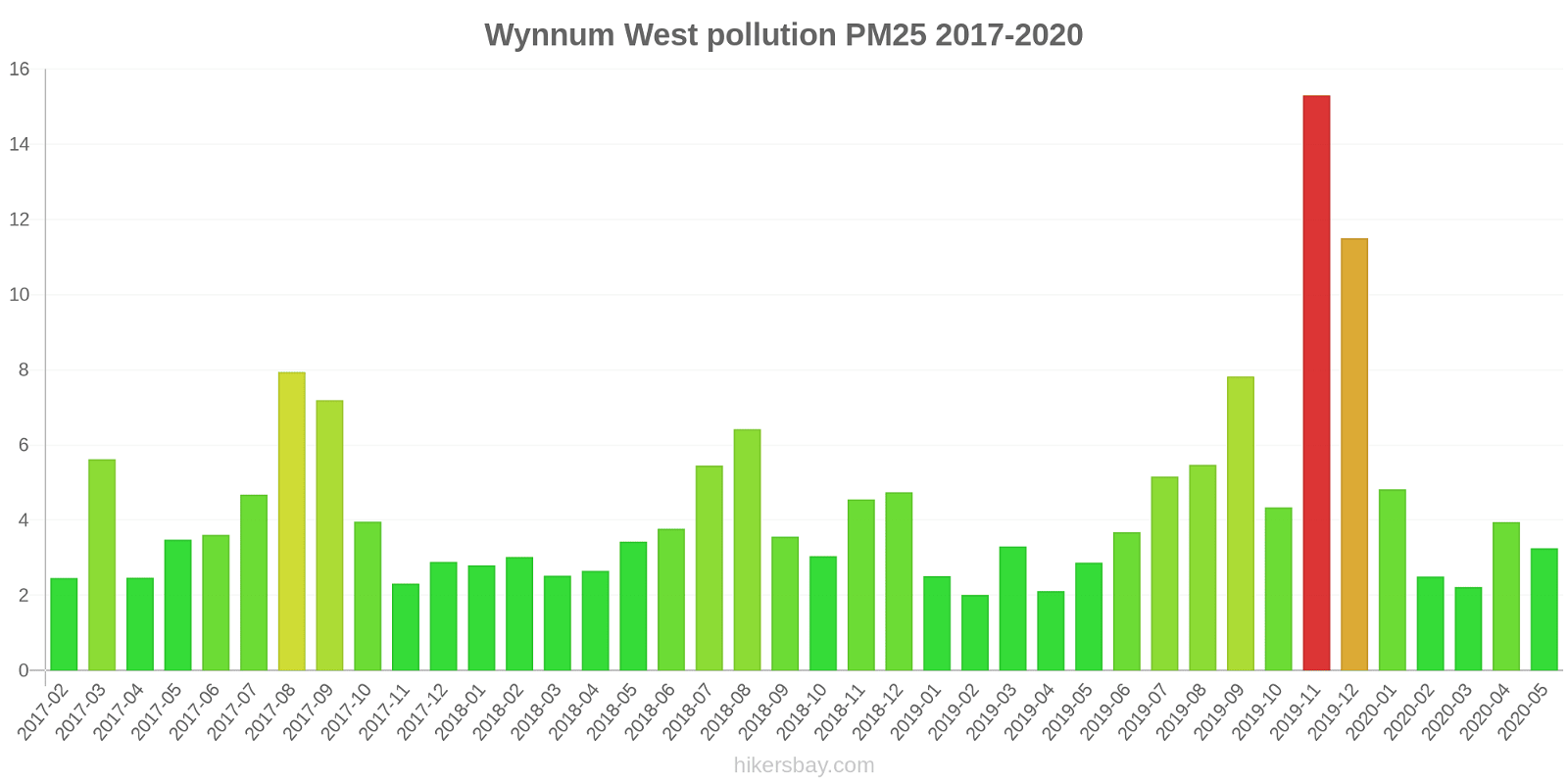
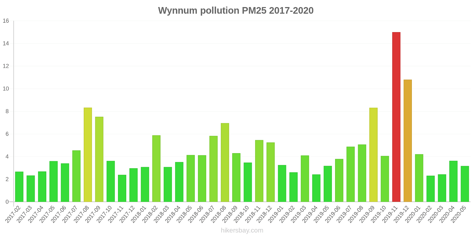
Inquinamento atmosferico in Queensland da febbraio 2017 a maggio 2020

index
2020-05
2020-04
2020-03
2020-02
2020-01
2019-12
2019-11
2019-10
2019-09
2019-08
2019-07
2019-06
2019-05
2019-04
2019-03
2019-02
2019-01
2018-12
2018-11
2018-10
2018-09
2018-08
2018-07
2018-06
2018-05
2018-04
2018-03
2018-02
2018-01
2017-12
2017-11
2017-10
2017-09
2017-08
2017-07
2017-06
2017-05
2017-04
2017-03
2017-02
pm10
16 (Good)
16 (Good)
14 (Good)
15 (Good)
19 (Good)
34 (Moderate)
38 (Moderate)
22 (Moderate)
35 (Moderate)
19 (Good)
16 (Good)
14 (Good)
14 (Good)
14 (Good)
16 (Good)
18 (Good)
18 (Good)
21 (Moderate)
25 (Moderate)
15 (Good)
21 (Moderate)
20 (Moderate)
16 (Good)
15 (Good)
16 (Good)
15 (Good)
15 (Good)
14 (Good)
16 (Good)
14 (Good)
14 (Good)
16 (Good)
25 (Moderate)
22 (Moderate)
14 (Good)
15 (Good)
14 (Good)
15 (Good)
13 (Good)
16 (Good)
pm25
4.6 (Good)
5.1 (Good)
4.1 (Good)
4.7 (Good)
7.1 (Good)
14 (Moderate)
16 (Moderate)
7.3 (Good)
12 (Good)
6.1 (Good)
6 (Good)
5.7 (Good)
4 (Good)
3.8 (Good)
4.7 (Good)
4.5 (Good)
5.2 (Good)
7.5 (Good)
9.8 (Good)
6 (Good)
6.8 (Good)
7.7 (Good)
7.1 (Good)
5.7 (Good)
4.8 (Good)
4.5 (Good)
5 (Good)
4.9 (Good)
5 (Good)
4.8 (Good)
4.6 (Good)
5.5 (Good)
9.4 (Good)
9.1 (Good)
6.2 (Good)
5.4 (Good)
4.6 (Good)
4.2 (Good)
4.3 (Good)
4.9 (Good)
o3:ppm
0.02 (Good)
0.02 (Good)
0.02 (Good)
0.02 (Good)
0.02 (Good)
0.03 (Good)
0.03 (Good)
0.02 (Good)
0.02 (Good)
0.02 (Good)
0.02 (Good)
0.02 (Good)
0.02 (Good)
0.02 (Good)
0.02 (Good)
0.02 (Good)
0.02 (Good)
0.02 (Good)
0.02 (Good)
0.03 (Good)
0.02 (Good)
0.02 (Good)
0.02 (Good)
0.02 (Good)
0.02 (Good)
0.02 (Good)
0.02 (Good)
0.02 (Good)
0.02 (Good)
0.02 (Good)
0.02 (Good)
0.03 (Good)
0.03 (Good)
0.02 (Good)
0.02 (Good)
0.02 (Good)
0.02 (Good)
0.02 (Good)
0.02 (Good)
0.02 (Good)
no2:ppm
- (Good)
- (Good)
- (Good)
- (Good)
- (Good)
- (Good)
- (Good)
- (Good)
- (Good)
- (Good)
- (Good)
- (Good)
0.01 (Good)
0.01 (Good)
0 (Good)
0 (Good)
0 (Good)
0 (Good)
0.01 (Good)
0.01 (Good)
0.01 (Good)
0.01 (Good)
0.01 (Good)
0.01 (Good)
0.01 (Good)
0.01 (Good)
0 (Good)
0 (Good)
0 (Good)
0 (Good)
0 (Good)
0.01 (Good)
0.01 (Good)
0.01 (Good)
0.01 (Good)
0.01 (Good)
0.01 (Good)
0.01 (Good)
0 (Good)
0 (Good)
so2:ppm
- (Good)
- (Good)
- (Good)
- (Good)
- (Good)
- (Good)
- (Good)
- (Good)
- (Good)
- (Good)
- (Good)
- (Good)
0 (Good)
0 (Good)
0 (Good)
0.01 (Good)
0 (Good)
0 (Good)
0.01 (Good)
0 (Good)
0 (Good)
0 (Good)
0 (Good)
0 (Good)
0 (Good)
0 (Good)
0 (Good)
0.04 (Good)
0 (Good)
0 (Good)
0.01 (Good)
0 (Good)
0.01 (Good)
0 (Good)
0.01 (Good)
0 (Good)
0 (Good)
0 (Good)
0 (Good)
0 (Good)
co:ppm
- (Good)
- (Good)
- (Good)
- (Good)
- (Good)
- (Good)
- (Good)
- (Good)
- (Good)
- (Good)
- (Good)
- (Good)
0.29 (Good)
0.15 (Good)
0.2 (Good)
0.25 (Good)
0.15 (Good)
0.26 (Good)
0.14 (Good)
0.23 (Good)
0.25 (Good)
0.35 (Good)
0.31 (Good)
0.26 (Good)
0.28 (Good)
0.32 (Good)
0.31 (Good)
0.3 (Good)
0.23 (Good)
0.3 (Good)
0.29 (Good)
0.3 (Good)
0.43 (Good)
0.78 (Good)
0.39 (Good)
0.13 (Good)
0.2 (Good)
0.28 (Good)
0.34 (Good)
0.35 (Good)
data source »
Qualità della vita in Queensland
Verde e parchi in città
Queensland
71%
Timor Est: 53%
Papua Nuova Guinea: 27%
Nuova Caledonia: 70%
particolato PM2.5
Queensland
6.8 (Good)
Il piacere di trascorrere del tempo in città
Queensland
73%
Timor Est: 44%
Papua Nuova Guinea: 34%
particolato PM10
Queensland
16 (Good)
Inquinamento dell'aria
Queensland
25%
Timor Est: 36%
Papua Nuova Guinea: 63%
Nuova Caledonia: 55%
Smaltimento dei rifiuti
Queensland
65%
Timor Est: 19%
Papua Nuova Guinea: 18%
Nuova Caledonia: 30%
Disponibilità e qualità dell'acqua potabile
Queensland
72%
Timor Est: 38%
Papua Nuova Guinea: 38%
Nuova Caledonia: 75%
Pulizia e ordine
Queensland
64%
Timor Est: 25%
Papua Nuova Guinea: 22%
Nuova Caledonia: 30%
Rumore e inquinamento luminoso
Queensland
36%
Timor Est: 53%
Papua Nuova Guinea: 58%
Nuova Caledonia: 45%
Inquinamento delle acque
Queensland
40%
Timor Est: 64%
Papua Nuova Guinea: 76%
Nuova Caledonia: 55%
Source: Numbeo
Auckland Point
lunedì 15 aprile 2024, 17:00
PM10 21 (Moderata)
polveri sospese di particolato (PM10)
Boat Creek
lunedì 15 aprile 2024, 17:00
PM2,5 5 (Buono)
polvere di particolato (PM2.5)
PM10 18 (Buono)
polveri sospese di particolato (PM10)
Boyne Island
lunedì 15 aprile 2024, 17:00
PM10 14 (Buono)
polveri sospese di particolato (PM10)
PM2,5 5 (Buono)
polvere di particolato (PM2.5)
Clinton
lunedì 15 aprile 2024, 17:00
PM2,5 4.8 (Buono)
polvere di particolato (PM2.5)
PM10 16 (Buono)
polveri sospese di particolato (PM10)
Fisherman's Landing
lunedì 15 aprile 2024, 17:00
PM10 21 (Moderata)
polveri sospese di particolato (PM10)
PM2,5 6.5 (Buono)
polvere di particolato (PM2.5)
Memorial Park
lunedì 15 aprile 2024, 17:00
O3 0.02 (Buono)
ozono (O3)
South Gladstone
lunedì 15 aprile 2024, 17:00
PM10 16 (Buono)
polveri sospese di particolato (PM10)
PM2,5 5.3 (Buono)
polvere di particolato (PM2.5)
Targinie
lunedì 15 aprile 2024, 17:00
PM10 13 (Buono)
polveri sospese di particolato (PM10)
PM2,5 4.6 (Buono)
polvere di particolato (PM2.5)
Blackwater
lunedì 15 aprile 2024, 17:00
PM10 14 (Buono)
polveri sospese di particolato (PM10)
PM2,5 4.2 (Buono)
polvere di particolato (PM2.5)
Emerald
lunedì 15 aprile 2024, 17:00
PM10 15 (Buono)
polveri sospese di particolato (PM10)
PM2,5 4.3 (Buono)
polvere di particolato (PM2.5)
West Mackay
lunedì 15 aprile 2024, 17:00
PM10 15 (Buono)
polveri sospese di particolato (PM10)
PM2,5 5 (Buono)
polvere di particolato (PM2.5)
Brisbane CBD
lunedì 15 aprile 2024, 17:00
PM2,5 5.2 (Buono)
polvere di particolato (PM2.5)
PM10 16 (Buono)
polveri sospese di particolato (PM10)
Cannon Hill
lunedì 15 aprile 2024, 17:00
O3 0 (Buono)
ozono (O3)
PM2,5 5.8 (Buono)
polvere di particolato (PM2.5)
PM10 17 (Buono)
polveri sospese di particolato (PM10)
Deception Bay
lunedì 15 aprile 2024, 17:00
O3 0.01 (Buono)
ozono (O3)
PM10 13 (Buono)
polveri sospese di particolato (PM10)
PM2,5 4.6 (Buono)
polvere di particolato (PM2.5)
Flinders View
lunedì 15 aprile 2024, 17:00
O3 0 (Buono)
ozono (O3)
PM10 15 (Buono)
polveri sospese di particolato (PM10)
PM2,5 5 (Buono)
polvere di particolato (PM2.5)
Lytton
lunedì 15 aprile 2024, 17:00
PM10 20 (Moderata)
polveri sospese di particolato (PM10)
PM2,5 3.9 (Buono)
polvere di particolato (PM2.5)
Mountain Creek
lunedì 15 aprile 2024, 17:00
PM10 12 (Buono)
polveri sospese di particolato (PM10)
PM2,5 4.4 (Buono)
polvere di particolato (PM2.5)
O3 0 (Buono)
ozono (O3)
Mutdapilly
mercoledì 7 febbraio 2024, 06:00
O3 0.02 (Buono)
ozono (O3)
PM10 60 (Non integro per i gruppi sensibili)
polveri sospese di particolato (PM10)
PM2,5 11 (Buono)
polvere di particolato (PM2.5)
North Maclean
lunedì 15 aprile 2024, 17:00
O3 0 (Buono)
ozono (O3)
PM2,5 5.7 (Buono)
polvere di particolato (PM2.5)
PM10 14 (Buono)
polveri sospese di particolato (PM10)
Rocklea
mercoledì 7 febbraio 2024, 06:00
PM2,5 4.9 (Buono)
polvere di particolato (PM2.5)
O3 0.01 (Buono)
ozono (O3)
PM10 13 (Buono)
polveri sospese di particolato (PM10)
South Brisbane
lunedì 15 aprile 2024, 18:00
PM10 17 (Buono)
polveri sospese di particolato (PM10)
PM2,5 5.6 (Buono)
polvere di particolato (PM2.5)
Southport
lunedì 15 aprile 2024, 17:00
PM2,5 4.5 (Buono)
polvere di particolato (PM2.5)
O3 0.01 (Buono)
ozono (O3)
PM10 13 (Buono)
polveri sospese di particolato (PM10)
Springwood
lunedì 15 aprile 2024, 18:00
O3 0.01 (Buono)
ozono (O3)
PM10 14 (Buono)
polveri sospese di particolato (PM10)
PM2,5 5 (Buono)
polvere di particolato (PM2.5)
Woolloongabba
lunedì 15 aprile 2024, 18:00
PM2,5 4.8 (Buono)
polvere di particolato (PM2.5)
PM10 17 (Buono)
polveri sospese di particolato (PM10)
Wynnum West
lunedì 15 aprile 2024, 17:00
PM10 8.9 (Buono)
polveri sospese di particolato (PM10)
PM2,5 2.4 (Buono)
polvere di particolato (PM2.5)
Deception Bay
lunedì 15 aprile 2024, 17:00
PM2,5 2.3 (Buono)
polvere di particolato (PM2.5)
PM10 7.7 (Buono)
polveri sospese di particolato (PM10)
Hopeland
lunedì 5 giugno 2023, 20:00
PM10 6.6 (Buono)
polveri sospese di particolato (PM10)
PM2,5 3.6 (Buono)
polvere di particolato (PM2.5)
O3 0.02 (Buono)
ozono (O3)
Miles Airport
lunedì 5 giugno 2023, 20:00
PM10 7.7 (Buono)
polveri sospese di particolato (PM10)
O3 -9999 (Buono)
ozono (O3)
PM2,5 4.5 (Buono)
polvere di particolato (PM2.5)
Upper Humbug
venerdì 27 maggio 2022, 12:00
NO2 7.3 (Buono)
biossido di azoto (NO2)
PM10 19 (Buono)
polveri sospese di particolato (PM10)
O3 91 (Moderata)
ozono (O3)
PM2,5 10 (Buono)
polvere di particolato (PM2.5)
SO2 0.1 (Buono)
biossido di zolfo (SO2)
CO 100 (Buono)
monossido di carbonio (CO)
Coastguard
lunedì 15 aprile 2024, 17:00
PM10 18 (Buono)
polveri sospese di particolato (PM10)
Environment Park
lunedì 15 aprile 2024, 17:00
PM10 16 (Buono)
polveri sospese di particolato (PM10)
Lennon Drive
lunedì 15 aprile 2024, 17:00
PM10 18 (Buono)
polveri sospese di particolato (PM10)
North Ward
lunedì 15 aprile 2024, 17:00
PM10 18 (Buono)
polveri sospese di particolato (PM10)
PM2,5 5.5 (Buono)
polvere di particolato (PM2.5)
Stuart
lunedì 15 aprile 2024, 17:00
PM2,5 3.6 (Buono)
polvere di particolato (PM2.5)
PM10 11 (Buono)
polveri sospese di particolato (PM10)
O3 0.05 (Buono)
ozono (O3)
The Gap
lunedì 15 aprile 2024, 17:00
PM2,5 4.7 (Buono)
polvere di particolato (PM2.5)
PM10 15 (Buono)
polveri sospese di particolato (PM10)
Auckland Point
index
2024-04-15
2024-04-14
2024-04-13
2024-04-12
2024-04-11
2024-04-10
2024-04-09
2024-04-08
pm10
21
17
21
44
41
14
12
7.4
Boat Creek
index
2024-04-15
2024-04-14
2024-04-13
2024-04-12
2024-04-11
2024-04-10
2024-04-09
2024-04-08
pm25
5
5.2
5.4
5.9
3.2
4.8
5.7
3.7
pm10
16
17
18
19
15
22
19
16
Boyne Island
index
2024-04-15
2024-04-14
2024-04-13
2024-04-12
2024-04-11
2024-04-10
2024-04-09
2024-04-08
pm10
14
15
15
16
11
12
12
9.9
pm25
5.2
5.3
5.1
5.9
3.1
3.8
4.6
2.6
Clinton
index
2024-04-15
2024-04-14
2024-04-13
2024-04-12
2024-04-11
2024-04-10
2024-04-09
2024-04-08
pm25
4.9
4.9
5.2
5.9
3.2
4.3
5
2.5
pm10
16
14
17
19
12
13
13
8.6
Fisherman's Landing
index
2024-04-15
2024-04-14
2024-04-13
2024-04-12
2024-04-11
2024-04-10
2024-04-09
2024-04-08
pm10
23
21
18
20
27
36
25
10
pm25
6.7
6.1
6
7.6
8.4
10
8.9
4.1
Memorial Park
index
2024-04-15
2024-04-14
2024-04-13
2024-04-12
2024-04-11
2024-04-10
2024-04-09
2024-04-08
o3
0.02
0.02
0.02
0.03
0.03
0.03
0.03
0.02
South Gladstone
index
2024-04-15
2024-04-14
2024-04-13
2024-04-12
2024-04-11
2024-04-10
2024-04-09
2024-04-08
pm10
16
17
17
19
12
13
13
9.3
pm25
5.3
5.5
5.5
6.3
3.3
4.2
5
2.7
Targinie
index
2024-04-15
2024-04-14
2024-04-13
2024-04-12
2024-04-11
2024-04-10
2024-04-09
2024-04-08
pm10
13
14
14
15
10
12
13
11
pm25
4.6
4.8
4.8
5.4
2.7
3.8
4.7
2.7
Blackwater
index
2024-04-15
2024-04-14
2024-04-13
2024-04-12
2024-04-11
2024-04-10
2024-04-09
2024-04-08
pm10
14
13
15
17
20
27
21
12
pm25
4.5
4.5
5
4.1
3.9
5.8
5.7
3.4
Emerald
index
2024-04-15
2024-04-14
2024-04-13
2024-04-12
2024-04-11
2024-04-10
2024-04-09
2024-04-08
pm10
15
15
17
16
13
15
14
9.7
pm25
4.4
4.6
5.1
3.8
2.8
4.7
5.5
3.2
West Mackay
index
2024-04-15
2024-04-14
2024-04-13
2024-04-12
2024-04-11
2024-04-10
2024-04-09
2024-04-08
pm10
14
15
17
17
18
20
18
18
pm25
4.8
5
5.8
4.7
4
5.3
4.7
4.5
Brisbane CBD
index
2024-04-15
2024-04-14
2024-04-13
2024-04-12
2024-04-11
2024-04-10
2024-04-09
2024-04-08
pm25
5.3
5.6
5.4
5.5
4.2
3.7
4.8
4
pm10
16
15
15
16
13
12
13
12
Cannon Hill
index
2024-04-15
2024-04-14
2024-04-13
2024-04-12
2024-04-11
2024-04-10
2024-04-09
2024-04-08
pm10
16
14
14
16
21
18
14
13
pm25
5.8
5.8
5.3
5.5
4.8
3.9
4.8
3.9
o3
0.01
0.01
0.01
0.01
0.02
0.02
0.02
0.02
Deception Bay
index
2024-04-15
2024-04-14
2024-04-13
2024-04-12
2024-04-11
2024-04-10
2024-04-09
2024-04-08
pm25
4.8
5.3
5
5.4
4.3
3.5
4.6
3.8
pm10
13
15
14
15
13
12
13
12
o3
0.02
0.02
0.02
0.02
0.02
0.02
0.02
0.03
Flinders View
index
2024-04-15
2024-04-14
2024-04-13
2024-04-12
2024-04-11
2024-04-10
2024-04-09
2024-04-08
pm25
5.2
5.6
5.3
4.9
4
3.6
4.8
3.9
pm10
14
14
14
14
12
12
13
11
o3
0.02
0.02
0.01
0.01
0.01
0.02
0.02
0.02
Lytton
index
2024-04-15
2024-04-14
2024-04-13
2024-04-12
2024-04-11
2024-04-10
2024-04-09
2024-04-08
pm10
20
13
14
23
28
24
18
18
pm25
4
3.4
3.1
4.5
5
3.3
2.7
3.3
Mountain Creek
index
2024-04-15
2024-04-14
2024-04-13
2024-04-12
2024-04-11
2024-04-10
2024-04-09
2024-04-08
o3
0.01
0.01
0.01
0.02
0.02
0.02
0.03
0.02
pm25
4.6
5
5.3
6.2
4.2
3.3
4.4
3.5
pm10
12
12
14
17
13
12
12
12
Mutdapilly
index
2024-02-07
2024-02-06
2024-02-05
2024-02-04
2024-02-03
2024-02-02
2024-01-31
o3
0.01
0.01
0.02
0.02
0.02
0.01
0.01
pm25
9.7
7.5
9.3
7.2
6.9
6
6
pm10
50
22
26
19
23
21
19
North Maclean
index
2024-04-15
2024-04-14
2024-04-13
2024-04-12
2024-04-11
2024-04-10
2024-04-09
2024-04-08
pm10
14
17
15
14
12
12
11
12
pm25
5.8
7.6
6.2
5.5
4.5
3.6
4
4
o3
0.02
0.01
0.01
0.01
0.01
0.01
0.03
0.02
Rocklea
index
2024-02-07
2024-02-06
2024-02-05
2024-02-04
2024-02-03
2024-02-02
2024-01-31
o3
0.01
0.01
0.01
0.01
0.01
0.01
0.01
pm10
13
14
18
17
13
13
17
pm25
5.1
5.8
6.8
8.6
6.4
5.5
6.7
South Brisbane
index
2024-04-15
2024-04-14
2024-04-13
2024-04-12
2024-04-11
2024-04-10
2024-04-09
2024-04-08
pm10
16
15
16
18
15
14
15
13
pm25
5.7
5.9
5.8
6
4.7
4.4
5.7
4.5
Southport
index
2024-04-15
2024-04-14
2024-04-13
2024-04-12
2024-04-11
2024-04-10
2024-04-09
2024-04-08
pm10
13
14
14
16
14
11
15
14
o3
0.02
0.01
0.01
0.01
0.02
0.02
0.02
0.02
pm25
4.7
5.3
5.1
5.6
4.4
3.7
5.2
4.3
Springwood
index
2024-04-15
2024-04-14
2024-04-13
2024-04-12
2024-04-11
2024-04-10
2024-04-09
2024-04-08
pm25
5.2
5.8
5.4
5.8
4.4
3.9
4.9
3.9
o3
0.02
0.01
0.01
0.02
0.02
0.02
0.02
0.02
pm10
14
14
15
18
15
14
14
13
Woolloongabba
index
2024-04-15
2024-04-14
2024-04-13
2024-04-12
2024-04-11
2024-04-10
2024-04-09
2024-04-08
pm25
5.1
5
5.1
5.5
4.7
4
4.8
4
pm10
16
14
16
21
22
21
20
16
Wynnum West
index
2024-04-15
2024-04-14
2024-04-13
2024-04-12
2024-04-11
2024-04-10
2024-04-09
2024-04-08
pm10
9.4
9.7
9.8
13
11
14
14
10
pm25
2.6
2.8
2.4
2.9
2.7
2.1
2.5
2.2
Deception Bay
index
2024-04-15
2024-04-14
2024-04-13
2024-04-12
2024-04-11
2024-04-10
2024-04-09
2024-04-08
pm25
2.5
2.5
2.3
2.9
3
2.4
2.5
2.4
pm10
8.1
8.6
8.8
12
12
17
16
9.1
Hopeland
index
2023-06-05
2023-06-09
2023-06-06
2023-06-08
2023-06-07
2023-06-10
2023-06-11
pm10
5.7
4
5.5
5.5
6.5
5.9
8.5
pm25
3.2
1.7
2.5
2.1
2.4
2.1
3
o3
0.02
0.02
0.02
0.02
0.02
0.01
0.01
Miles Airport
index
2023-06-05
2023-06-09
2023-06-06
2023-06-08
2023-06-07
2023-06-10
2023-06-11
pm10
7.1
4.2
6.9
7.4
7.2
6
8.8
o3
-454.48
0.02
0.01
0.02
0.02
0.02
0.01
pm25
4.2
1.6
3.1
2.3
2.3
1.9
3.2
Upper Humbug
index
2022-05-27
no2
20
pm10
27
o3
39
pm25
20
so2
4.9
co
240
Coastguard
index
2024-04-15
2024-04-14
2024-04-13
2024-04-12
2024-04-11
2024-04-10
2024-04-09
2024-04-08
pm10
18
19
18
17
19
16
9.5
7.1
Environment Park
index
2024-04-15
2024-04-14
2024-04-13
2024-04-12
2024-04-11
2024-04-10
2024-04-09
2024-04-08
pm10
17
17
15
15
18
14
9.6
10
Lennon Drive
index
2024-04-15
2024-04-14
2024-04-13
2024-04-12
2024-04-11
2024-04-10
2024-04-09
2024-04-08
pm10
18
18
19
18
19
16
9.6
7.5
North Ward
index
2024-04-15
2024-04-14
2024-04-13
2024-04-12
2024-04-11
2024-04-10
2024-04-09
2024-04-08
pm10
18
19
18
17
20
18
10
7.5
pm25
5.6
6.3
5.7
5.1
8
6.3
4
2.9
Stuart
index
2024-04-15
2024-04-14
2024-04-13
2024-04-12
2024-04-11
2024-04-10
2024-04-09
2024-04-08
pm10
12
12
17
19
36
18
15
8.8
pm25
4
4.1
5.8
7.3
13
7.5
4.5
3
o3
0.04
0.04
0.05
0.04
0.04
0.05
0.05
0.05
The Gap
index
2024-04-15
2024-04-14
2024-04-13
2024-04-12
2024-04-11
2024-04-10
2024-04-09
2024-04-08
pm25
4.3
4.4
3.9
2.7
2.4
3.1
4.1
4.2
pm10
13
13
13
11
9.9
11
13
10
Auckland Point
index
2020-05
2020-04
2020-03
2020-02
2020-01
2019-12
2019-11
2019-10
2019-09
2019-08
2019-07
2019-06
2019-05
2019-04
2019-03
2019-02
2019-01
2018-12
2018-11
2018-10
2018-09
2018-08
2018-07
2018-06
2018-05
2018-04
2018-03
2018-02
2018-01
2017-12
2017-11
2017-10
2017-09
2017-08
2017-07
2017-06
2017-05
2017-04
2017-03
2017-02
pm10
19
28
23
14
17
31
34
22
31
15
16
14
15
18
13
19
24
25
33
17
23
18
16
16
18
24
12
20
20
16
18
20
23
19
15
16
16
18
16
21
Boat Creek
2017-02 2020-05
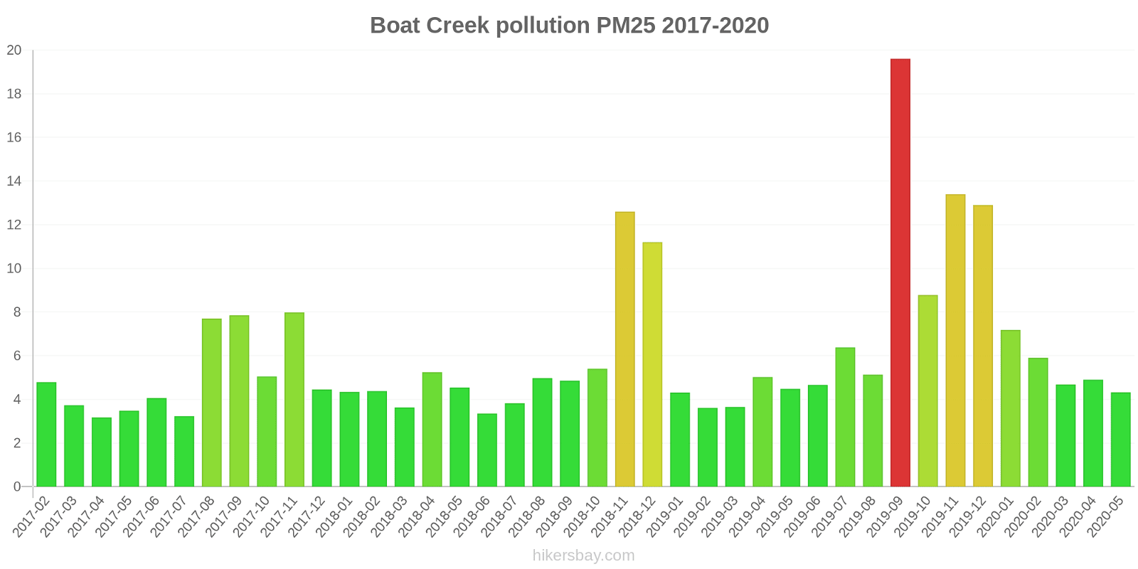
index
2020-05
2020-04
2020-03
2020-02
2020-01
2019-12
2019-11
2019-10
2019-09
2019-08
2019-07
2019-06
2019-05
2019-04
2019-03
2019-02
2019-01
2018-12
2018-11
2018-10
2018-09
2018-08
2018-07
2018-06
2018-05
2018-04
2018-03
2018-02
2018-01
2017-12
2017-11
2017-10
2017-09
2017-08
2017-07
2017-06
2017-05
2017-04
2017-03
2017-02
no2:ppm
-
-
-
-
-
-
-
-
-
-
-
-
0
0
0
0
0
0
0
0
0.01
0.01
0
0
0
0
0
0
0
0
0
0
0.01
0.01
0.01
0.01
0.01
0
0
0
so2:ppm
-
-
-
-
-
-
-
-
-
-
-
-
0
0
0
0
0
0
0
0
0
0
0
0
0
0
0
0
0
0
0
0
0
0
0
0
0
0
0
0
pm10
15
15
15
15
17
33
33
23
39
16
17
14
15
16
11
14
16
24
28
13
17
13
11
11
12
14
13
13
16
13
17
13
19
16
9.5
12
12
13
12
16
pm25
4.3
4.9
4.7
5.9
7.2
13
13
8.8
20
5.1
6.4
4.7
4.5
5
3.6
3.6
4.3
11
13
5.4
4.8
5
3.8
3.4
4.5
5.2
3.6
4.4
4.3
4.5
8
5
7.8
7.7
3.2
4.1
3.5
3.2
3.7
4.8
Boyne Island
2017-02 2020-05

index
2020-05
2020-04
2020-03
2020-02
2020-01
2019-12
2019-11
2019-10
2019-09
2019-08
2019-07
2019-06
2019-05
2019-04
2019-03
2019-02
2019-01
2018-12
2018-11
2018-10
2018-09
2018-08
2018-07
2018-06
2018-05
2018-04
2018-03
2018-02
2018-01
2017-12
2017-11
2017-10
2017-09
2017-08
2017-07
2017-06
2017-05
2017-04
2017-03
2017-02
pm10
13
13
10
12
16
31
31
21
19
5.5
4.5
4.7
7.8
11
8.7
14
18
14
11
9.8
15
15
10
10
11
15
13
12
11
9.9
7.8
8
11
7.7
8.8
8.5
9
12
13
15
pm25
4.1
4.5
3.6
4.6
7
13
14
8.6
8.2
3.5
3.1
1.7
2.1
2.3
2.6
3.6
5.9
3.7
12
5.6
5.7
6.3
5.2
4.1
3.1
4.4
4.5
4.5
3.4
6.6
4.2
4.9
7.7
6.4
2.4
3
2.9
3.4
4
4.8
no2:ppm
-
-
-
-
-
-
-
-
-
-
-
-
-
-
0
0
-
0
0
0
0
0
0
0
0
0
-
0
0
0
0
0
0
0
0
0
0
0
0
-
so2:ppm
-
-
-
-
-
-
-
-
-
-
-
-
0
0
0
0
0
0
0
0
0
0
0
0
0
0
-
0
0
0
-
0
0
-
-
-
0
-
0
-
Clinton
2017-02 2020-05

index
2020-05
2020-04
2020-03
2020-02
2020-01
2019-12
2019-11
2019-10
2019-09
2019-08
2019-07
2019-06
2019-05
2019-04
2019-03
2019-02
2019-01
2018-12
2018-11
2018-10
2018-09
2018-08
2018-07
2018-06
2018-05
2018-04
2018-03
2018-02
2018-01
2017-12
2017-11
2017-10
2017-09
2017-08
2017-07
2017-06
2017-05
2017-04
2017-03
2017-02
no2:ppm
-
-
-
-
-
-
-
-
-
-
-
-
0
0
0
0
0
0
0
0
0.01
0.01
0.01
0.01
0.01
0
0
0
0
0
0
0
0.01
0.01
0.01
0.01
0
0
0
0
pm10
15
15
15
15
18
36
37
25
35
16
16
13
13
15
11
17
20
23
33
13
24
14
14
14
12
14
13
13
14
10
11
9.7
18
14
8
8.8
7.1
11
10
14
pm25
5
5.8
4.9
6
7.8
15
16
10
16
6.3
6.3
5.3
4.4
5.2
5.6
5.5
8.6
11
19
6.8
15
7.5
8.4
7.8
4.5
5.6
4.9
7.3
6
4.5
4.6
3.1
8.3
6.7
2.4
3.2
2
1.8
2.8
4
so2:ppm
-
-
-
-
-
-
-
-
-
-
-
-
-
-
0
-
0
0
0
0
0
0
0
0
0
0
0
0
0
0
0
0
0
0
0.01
0
0
0
0
-
Fisherman's Landing
2017-02 2020-05

index
2020-05
2020-04
2020-03
2020-02
2020-01
2019-12
2019-11
2019-10
2019-09
2019-08
2019-07
2019-06
2019-05
2019-04
2019-03
2019-02
2019-01
2018-12
2018-11
2018-10
2018-09
2018-08
2018-07
2018-06
2018-05
2018-04
2018-03
2018-02
2018-01
2017-12
2017-11
2017-10
2017-09
2017-08
2017-07
2017-06
2017-05
2017-04
2017-03
2017-02
no2:ppm
-
-
-
-
-
-
-
-
-
-
-
-
0
0
0
0
0
0
0
0
0
0
0
0
0
0
0
0
0
0
0
0
0
0
0
0
0
0
0
0
pm10
35
21
22
20
21
44
45
28
83
46
36
27
26
27
16
25
23
22
11
9.6
20
40
22
45
54
-
34
23
32
26
27
27
47
46
19
40
27
37
18
33
pm25
2.8
2.7
3.7
5.7
6.6
13
14
8
27
6.6
6.4
4
2.7
3.6
4.3
6.7
5.9
5.4
9
6.8
8
6.5
4.5
5.7
5.9
-
13
4.9
5.9
5.5
5.3
6.8
11
7.8
3.4
7.9
3.6
5
4
8.6
so2:ppm
-
-
-
-
-
-
-
-
-
-
-
-
-
-
-
-
-
-
-
-
-
-
-
-
-
-
-
-
-
-
-
-
-
-
0
0
0
0
0
-
Memorial Park
index
2020-05
2020-04
2020-03
2020-01
2019-12
2019-11
2019-10
2019-09
2019-04
2019-03
2019-02
2019-01
2018-12
2018-11
2018-10
2018-09
2018-08
2018-07
2018-06
2018-05
2018-04
2018-03
2018-02
2018-01
2017-12
2017-11
2017-10
2017-09
2017-08
2017-07
2017-06
2017-05
2017-04
2017-03
2017-02
no2:ppm
-
-
-
-
-
-
-
-
0.01
0.01
0.01
0.01
0.01
0.01
0.01
0.01
0.01
0.01
0.01
0.01
0.01
0.01
0.01
0.01
0.01
0.01
0.01
0.01
0.01
0.01
0.01
0.01
0
0
0
o3:ppm
0.03
0.03
0.03
0.03
0.03
0.03
0.03
0.03
0.04
0.03
0.04
0.04
0.04
0.04
0.04
0.04
0.04
0.04
0.04
0.04
0.04
0.04
0.03
0.03
0.04
0.04
0.04
0.04
0.04
0.04
0.04
0.03
0.02
0.02
0.02
so2:ppm
-
-
-
-
-
-
-
-
0.01
0.01
0.01
0.01
0.01
0.01
0.01
0.01
0.01
0.01
0.01
0.01
0.01
0.01
0.01
0.01
0.01
0.01
0.01
0.01
0.01
0.01
0
0
0
0
0
South Gladstone
2017-02 2020-05
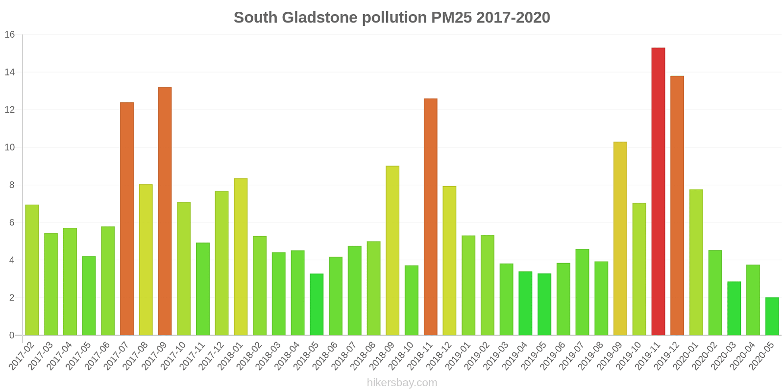
index
2020-05
2020-04
2020-03
2020-02
2020-01
2019-12
2019-11
2019-10
2019-09
2019-08
2019-07
2019-06
2019-05
2019-04
2019-03
2019-02
2019-01
2018-12
2018-11
2018-10
2018-09
2018-08
2018-07
2018-06
2018-05
2018-04
2018-03
2018-02
2018-01
2017-12
2017-11
2017-10
2017-09
2017-08
2017-07
2017-06
2017-05
2017-04
2017-03
2017-02
no2:ppm
-
-
-
-
-
-
-
-
-
-
-
-
0
0
0
0
0.01
0.01
0.01
0.01
0.01
0.01
0.01
0.01
0.01
0
0
0
0
0
0
0
0.01
0.01
0.01
0.01
0.01
0
0
0
so2:ppm
-
-
-
-
-
-
-
-
-
-
-
-
0
0
0
0
0
0
0
0
0
0
0
0
0
0
0
0
0
0
0
0
0
0
0
0
0
0
0
0
pm10
8.9
11
11
12
19
35
36
14
24
12
11
8.4
9.9
12
9.7
17
18
21
27
10
28
11
8.4
7.1
9.2
15
14
14
20
15
14
15
24
16
19
12
9.5
14
13
16
pm25
2
3.8
2.9
4.5
7.8
14
15
7
10
3.9
4.6
3.9
3.3
3.4
3.8
5.3
5.3
7.9
13
3.7
9
5
4.8
4.2
3.3
4.5
4.4
5.3
8.3
7.7
4.9
7.1
13
8
12
5.8
4.2
5.7
5.5
7
Targinie
2017-02 2020-05
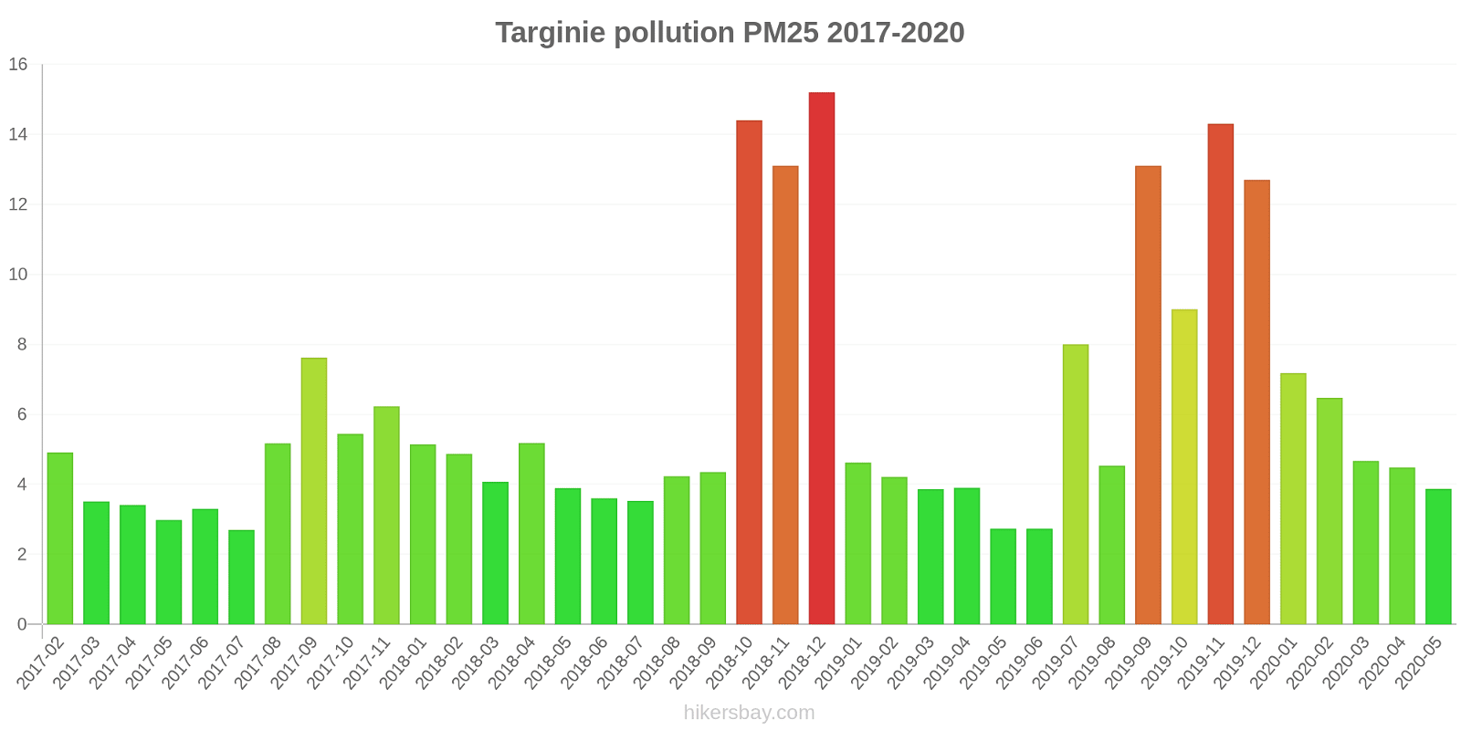
index
2020-05
2020-04
2020-03
2020-02
2020-01
2019-12
2019-11
2019-10
2019-09
2019-08
2019-07
2019-06
2019-05
2019-04
2019-03
2019-02
2019-01
2018-12
2018-11
2018-10
2018-09
2018-08
2018-07
2018-06
2018-05
2018-04
2018-03
2018-02
2018-01
2017-12
2017-11
2017-10
2017-09
2017-08
2017-07
2017-06
2017-05
2017-04
2017-03
2017-02
no2:ppm
-
-
-
-
-
-
-
-
-
-
-
-
0.01
0
0
0
0
0
0
0
0
0
0
0
0
0
0
0.01
0
0
0
0.01
0.01
0
0.01
0.01
0.01
0.01
0
0
so2:ppm
-
-
-
-
-
-
-
-
-
-
-
-
0
0
0
0
0
0
0
0
0
0
0
0
0
0
0
0
0
0
0
-
-
-
0
-
-
0
0
0
pm10
13
13
14
15
19
31
33
22
32
12
13
7.8
7
11
8.5
15
16
27
28
21
14
11
9
10
9.6
9.5
7.8
11
15
-
14
14
19
13
8.7
10
10
13
12
16
pm25
3.9
4.5
4.7
6.5
7.2
13
14
9
13
4.5
8
2.7
2.7
3.9
3.9
4.2
4.6
15
13
14
4.3
4.2
3.5
3.6
3.9
5.2
4.1
4.9
5.1
-
6.2
5.4
7.6
5.2
2.7
3.3
3
3.4
3.5
4.9
Blackwater
2019-04 2020-05
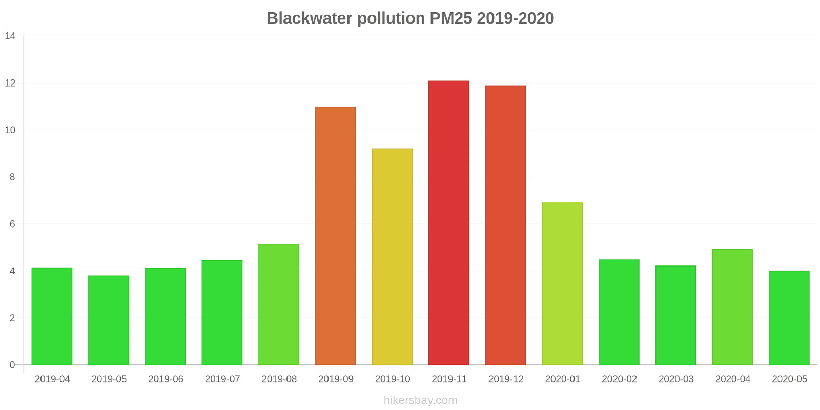
index
2020-05
2020-04
2020-03
2020-02
2020-01
2019-12
2019-11
2019-10
2019-09
2019-08
2019-07
2019-06
2019-05
2019-04
pm10
18
18
13
14
17
35
38
29
42
21
18
18
16
14
pm25
4
4.9
4.2
4.5
6.9
12
12
9.2
11
5.2
4.5
4.1
3.8
4.2
Moranbah
index
2020-05
2020-04
2020-03
2020-02
2020-01
2019-12
2019-11
2019-10
2019-09
2019-08
2019-07
2019-06
2019-05
2019-04
2019-03
2019-02
2019-01
2018-12
2018-11
2018-10
2018-09
2018-08
2018-07
2018-06
2018-05
2018-04
2018-03
2018-02
2018-01
2017-12
2017-11
2017-10
2017-09
2017-08
2017-07
2017-06
2017-05
2017-04
2017-03
2017-02
pm10
23
21
16
16
22
34
44
38
50
34
29
24
26
21
18
29
22
26
36
30
35
40
41
29
28
27
21
22
24
24
24
25
40
37
23
23
18
20
15
22
pm25
5.3
5.5
4.4
4.8
7.7
12
13
7.8
-
-
-
-
-
-
-
-
-
-
-
-
-
-
-
-
-
-
-
-
-
-
-
-
-
-
-
-
-
-
-
-
West Mackay
index
2020-05
2020-04
2020-03
2020-02
2020-01
2019-12
2019-11
2019-10
2019-09
2019-08
2019-07
2019-06
2019-05
2019-04
2019-03
2019-02
2019-01
2018-12
2018-11
2018-10
2018-09
2018-08
2018-07
2018-06
2018-05
2018-04
2018-03
2018-02
2018-01
2017-12
2017-11
2017-10
2017-09
2017-08
2017-07
2017-06
2017-05
2017-04
2017-03
2017-02
pm10
17
17
16
14
17
24
35
22
40
22
18
18
18
19
18
24
23
24
34
18
25
26
21
18
18
20
19
14
17
15
18
20
33
31
21
22
16
18
17
18
pm25
5.1
5.3
5.3
4.9
6.6
8.8
13
7.7
-
-
-
-
-
-
-
-
-
-
-
-
-
-
-
-
-
-
-
-
-
-
-
-
-
-
-
-
-
-
-
-
Brisbane CBD
index
2020-05
2020-04
2020-03
2020-02
2020-01
2019-12
2019-11
2019-10
2019-09
2019-08
2019-07
2019-06
2019-05
2019-04
2019-03
2019-02
2019-01
2018-12
2018-11
2018-10
2018-09
2018-08
2018-07
2018-06
2018-05
2018-04
2018-03
2018-02
2018-01
2017-12
2017-11
2017-10
2017-09
2017-08
2017-07
2017-06
2017-05
2017-04
2017-03
2017-02
pm10
15
16
15
15
16
31
37
17
30
19
14
12
11
11
14
16
15
19
23
13
20
19
14
12
12
12
13
15
14
10
9.7
13
20
20
12
11
12
11
12
13
pm25
5.4
6.1
5.3
5.6
6.5
-
-
-
-
-
-
-
-
-
-
-
-
-
-
-
-
-
-
-
-
-
-
-
-
-
-
-
-
-
-
-
-
-
-
-
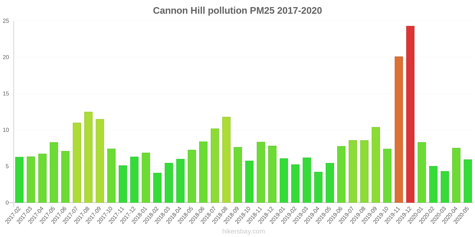
Cannon Hill
2017-02 2020-05
index
2020-05
2020-04
2020-03
2020-02
2020-01
2019-12
2019-11
2019-10
2019-09
2019-08
2019-07
2019-06
2019-05
2019-04
2019-03
2019-02
2019-01
2018-12
2018-11
2018-10
2018-09
2018-08
2018-07
2018-06
2018-05
2018-04
2018-03
2018-02
2018-01
2017-12
2017-11
2017-10
2017-09
2017-08
2017-07
2017-06
2017-05
2017-04
2017-03
2017-02
pm10
14
16
13
13
21
64
54
25
32
20
16
14
11
11
15
16
16
20
27
13
22
22
18
15
16
15
14
8.6
16
13
12
16
24
21
16
13
14
16
13
15
pm25
6
7.5
4.3
5
8.3
24
20
7.4
10
8.6
8.6
7.8
5.5
4.2
6.2
5.3
6.1
7.8
8.4
5.8
7.7
12
10
8.4
7.3
6
5.5
4.1
6.9
6.3
5.1
7.4
12
13
11
7.1
8.3
6.7
6.3
6.3
o3:ppm
0.02
0.02
0.02
0.01
0.02
0.03
0.02
0.02
0.02
0.02
0.01
0.01
0.01
0.01
0.02
0.01
0.01
0.02
0.02
0.02
0.02
0.02
0.02
0.01
0.01
0.01
0.01
0.02
0.01
0.02
0.02
0.02
0.02
0.02
0.01
0.01
0.01
0.02
-
-
Deception Bay
index
2020-05
2020-04
2020-03
2020-02
2020-01
2019-12
2019-11
2019-10
2019-09
2019-08
2019-07
2019-06
2019-05
2019-04
2019-03
2019-02
2019-01
2018-12
2018-11
2018-10
2018-09
2018-08
2018-07
2018-06
2018-05
2018-04
2018-03
2018-02
2018-01
2017-12
2017-11
2017-10
2017-09
2017-08
2017-07
2017-06
2017-05
2017-04
2017-03
2017-02
no2:ppm
-
-
-
-
-
-
-
-
-
-
-
-
0.01
0
0
0
0
0
0
0
0
0.01
0.01
0.01
0.01
0
0
0
0
0
0
0
0
0.01
0.01
0.01
0.01
0
0
0
o3:ppm
0.02
0.02
0.02
0.02
0.02
0.03
0.03
0.02
0.02
0.02
0.02
0.02
0.02
0.02
0.02
0.02
0.01
0.02
0.02
0.03
0.02
0.02
0.02
0.02
0.02
0.02
0.02
0.02
0.02
0.02
0.02
0.03
0.03
0.02
0.02
0.02
0.02
0.02
0.02
0.02
Flinders View
index
2020-05
2020-04
2020-03
2020-02
2020-01
2019-12
2019-11
2019-10
2019-09
2019-08
2019-07
2019-06
2019-05
2019-04
2019-03
2019-02
2019-01
2018-12
2018-11
2018-10
2018-09
2018-08
2018-07
2018-06
2018-05
2018-04
2018-03
2018-02
2018-01
2017-12
2017-11
2017-10
2017-09
2017-08
2017-07
2017-06
2017-05
2017-04
2017-03
2017-02
no2:ppm
-
-
-
-
-
-
-
-
-
-
-
-
0.01
0.01
0.01
0
0
0
0
0
0.01
0.01
0.01
0.01
0.01
0.01
0
0
0
0
0
0
0.01
0.01
0.01
0.01
0.01
0.01
0.01
0.01
o3:ppm
0.02
0.02
0.02
0.02
0.02
0.03
0.03
0.02
0.02
0.02
0.02
0.01
0.01
0.01
0.02
0.02
0.02
0.02
0.02
0.02
0.02
0.02
0.01
0.01
0.01
0.01
0.01
0.02
0.02
0.02
0.02
0.02
0.03
0.02
0.01
0.01
0.01
0.02
0.02
0.02
pm10
18
19
16
15
18
41
50
24
35
22
17
14
14
14
18
21
21
26
30
14
26
23
17
15
16
16
16
17
19
16
15
16
26
22
13
13
14
13
13
16
so2:ppm
-
-
-
-
-
-
-
-
-
-
-
-
-
-
-
-
-
-
-
-
0
0
0
0
0
0
0
-
0
0
0
0
-
-
-
-
0
0
0
-
Lytton
2017-02 2020-05

index
2020-05
2020-04
2020-03
2020-02
2020-01
2019-12
2019-11
2019-10
2019-09
2019-08
2019-07
2019-06
2019-05
2019-04
2019-03
2019-02
2019-01
2018-12
2018-11
2018-10
2018-09
2018-08
2018-07
2018-06
2018-05
2018-04
2018-03
2018-02
2018-01
2017-12
2017-11
2017-10
2017-09
2017-08
2017-07
2017-06
2017-05
2017-04
2017-03
2017-02
pm10
22
16
14
14
15
36
44
18
30
12
9.3
12
15
14
15
17
16
20
29
14
17
13
11
13
19
11
15
12
14
13
12
16
27
31
18
18
17
14
13
14
pm25
8.1
4.3
4
3.4
5.1
11
18
5.8
10
7.8
6.7
5.5
4.4
3.4
4.6
3.6
3.3
5.6
6.7
4.1
5
7.2
6.4
4.8
5.2
4
4.2
3.9
2.8
3.5
3.2
3.9
7.8
10
5.2
5
4.9
3.9
3
2.8
so2:ppm
-
-
-
-
-
-
-
-
-
-
-
-
-
-
0.01
0.01
-
-
-
0
0
0
0
0
0
0
0.01
0.01
0
0
0.01
-
0
0
-
-
-
-
-
-
Mountain Creek
index
2020-05
2020-04
2020-03
2020-02
2020-01
2019-12
2019-11
2019-10
2019-09
2019-08
2019-07
2019-06
2019-05
2019-04
2019-03
2019-02
2019-01
2018-12
2018-11
2018-10
2018-09
2018-08
2018-07
2018-06
2018-05
2018-04
2018-03
2018-02
2018-01
2017-12
2017-11
2017-10
2017-09
2017-08
2017-07
2017-06
2017-05
2017-04
2017-03
2017-02
no2:ppm
-
-
-
-
-
-
-
-
-
-
-
-
0
0
0
0
0
0
0
0
0
0.01
0.01
0.01
0
0
0
0
0
0
0
0
0
0.01
0.01
0.01
0.01
0
0
0
o3:ppm
0.02
0.02
0.02
0.02
0.02
0.02
0.02
0.02
0.03
0.02
0.02
0.02
0.02
0.02
0.02
0.02
0.01
0.02
0.02
0.02
0.02
0.02
0.02
0.02
0.02
0.02
0.02
0.02
0.02
0.02
0.02
0.03
0.03
0.03
0.02
0.02
0.02
0.02
0.02
0.02
pm10
15
16
15
17
19
37
36
21
37
19
16
14
14
18
19
25
21
26
27
17
21
19
16
14
15
19
21
20
21
16
17
20
25
20
11
12
14
15
18
19
Mutdapilly
index
2020-05
2020-04
2020-03
2020-02
2020-01
2019-12
2019-11
2019-10
2019-09
2019-08
2019-07
2019-06
2019-05
2019-04
2019-03
2019-02
2019-01
2018-12
2018-11
2018-10
2018-09
2018-08
2018-07
2018-06
2018-05
2018-04
2018-03
2018-02
2018-01
2017-12
2017-11
2017-10
2017-09
2017-08
2017-07
2017-06
2017-05
2017-04
2017-03
2017-02
no2:ppm
-
-
-
-
-
-
-
-
-
-
-
-
0
0
0
0
0
0
0
0
0
0
0.01
0
0
0
0
0
0
0
0
0
0
0.01
0
0
0
0
0
0
o3:ppm
0.02
0.02
0.02
0.02
0.02
0.03
0.03
0.03
0.03
0.02
0.03
0.02
0.02
0.02
0.02
0.02
0.02
0.02
0.03
0.03
0.03
0.03
0.02
0.02
0.02
0.02
0.02
0.02
0.02
0.02
0.02
0.03
0.03
0.03
0.02
0.02
0.02
0.02
0.02
0.02
North Maclean
index
2020-05
2020-04
2020-03
2020-02
2020-01
2019-12
2019-11
2019-10
2019-09
2019-08
2019-07
2019-06
2019-05
2019-04
2019-03
2019-02
2019-01
2018-12
2018-11
2018-10
2018-09
2018-08
2018-07
2018-06
2018-05
2018-04
2018-03
2018-02
2018-01
2017-12
2017-11
2017-10
2017-09
2017-08
2017-07
2017-06
2017-05
2017-04
2017-03
2017-02
no2:ppm
-
-
-
-
-
-
-
-
-
-
-
-
0
0
0
0
0
0
0
0
0
0.01
0.01
0.01
0
0
0
0
0
0
0
0
0.01
0.01
0
0
0
0
0
0
o3:ppm
0.02
0.02
0.02
0.02
0.02
0.02
0.03
0.02
0.02
0.02
0.01
0.02
0.01
0.02
0.02
0.02
0.01
0.01
0.02
0.02
0.02
0.02
0.02
0.01
0.02
0.01
0.01
0.02
0.02
0.02
0.02
0.02
0.02
0.02
0.01
0.02
0.02
0.02
0.02
0.02
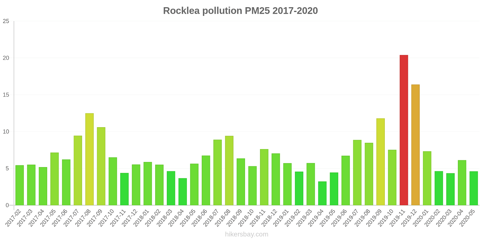
Rocklea
2017-02 2020-05
index
2020-05
2020-04
2020-03
2020-02
2020-01
2019-12
2019-11
2019-10
2019-09
2019-08
2019-07
2019-06
2019-05
2019-04
2019-03
2019-02
2019-01
2018-12
2018-11
2018-10
2018-09
2018-08
2018-07
2018-06
2018-05
2018-04
2018-03
2018-02
2018-01
2017-12
2017-11
2017-10
2017-09
2017-08
2017-07
2017-06
2017-05
2017-04
2017-03
2017-02
no2:ppm
-
-
-
-
-
-
-
-
-
-
-
-
0.01
0.01
0.01
0
0
0
0
0.01
0.01
0.01
0.01
0.01
0.01
0.01
0
0.01
0
0.01
0.01
0.01
0.01
0.01
0.01
0.01
0.01
0.01
0.01
0
o3:ppm
0.02
0.02
0.02
0.02
0.02
0.03
0.03
0.02
0.02
0.02
0.02
0.01
0.01
0.01
0.02
0.02
0.01
0.02
0.02
0.02
0.02
0.02
0.01
0.01
0.01
0.01
0.01
0.02
0.02
0.02
0.02
0.02
0.02
0.02
0.01
0.02
0.01
0.02
0.02
0.02
pm10
11
12
12
13
16
36
44
19
33
19
15
12
10
9.6
13
14
14
18
23
12
19
19
15
12
12
10
12
13
15
13
11
15
23
20
14
11
12
11
12
13
pm25
4.6
6.1
4.4
4.6
7.3
16
20
7.5
12
8.5
8.9
6.7
4.5
3.2
5.7
4.6
5.7
7
7.6
5.3
6.4
9.4
8.9
6.8
5.7
3.7
4.6
5.5
5.9
5.5
4.4
6.5
11
13
9.4
6.2
7.2
5.2
5.5
5.4
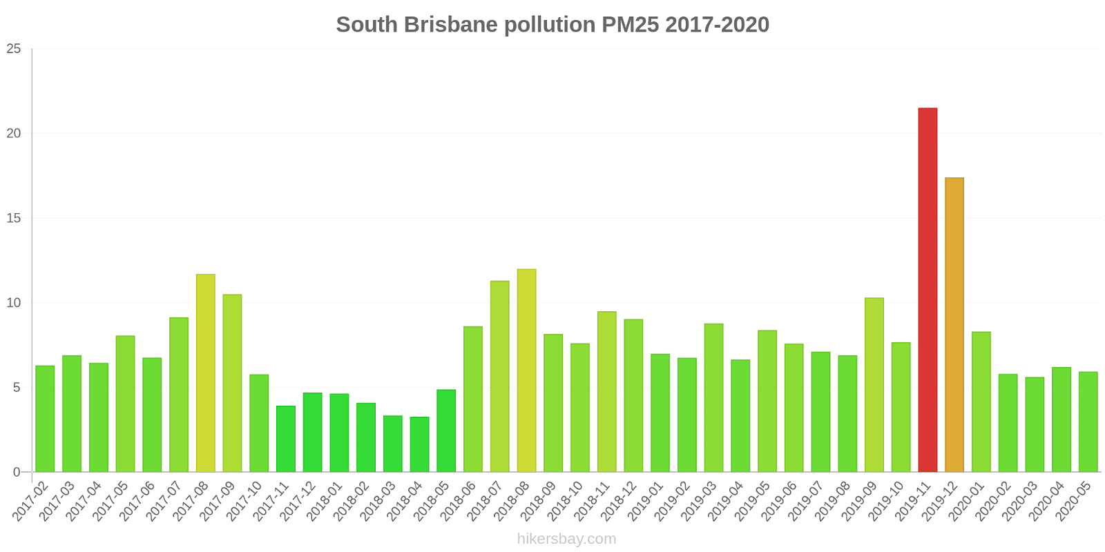
South Brisbane
2017-02 2020-05
index
2020-05
2020-04
2020-03
2020-02
2020-01
2019-12
2019-11
2019-10
2019-09
2019-08
2019-07
2019-06
2019-05
2019-04
2019-03
2019-02
2019-01
2018-12
2018-11
2018-10
2018-09
2018-08
2018-07
2018-06
2018-05
2018-04
2018-03
2018-02
2018-01
2017-12
2017-11
2017-10
2017-09
2017-08
2017-07
2017-06
2017-05
2017-04
2017-03
2017-02
co:ppm
-
-
-
-
-
-
-
-
-
-
-
-
-
0.05
-
-
-
-
0.12
0.19
0.36
0.8
0.74
0.66
0.75
0.63
0.57
0.55
0.49
0.5
0.46
0.47
0.77
1.4
0.6
0.09
0.2
0.28
0.34
0.35
no2:ppm
-
-
-
-
-
-
-
-
-
-
-
-
0.02
0.01
0.01
0.01
0.01
0.01
0.01
0.01
0.02
0.02
0.02
0.02
0.02
0.01
0.01
0.01
0.01
0.01
0.01
0.01
0.02
0.02
0.02
0.02
0.02
0.02
0.01
0.01
pm10
19
19
19
17
19
37
41
20
30
19
16
15
19
17
20
21
18
22
27
15
23
23
19
16
13
12
12
12
13
12
11
14
22
20
15
13
15
13
14
14
pm25
5.9
6.2
5.6
5.8
8.3
17
22
7.7
10
6.9
7.1
7.6
8.4
6.7
8.8
6.8
7
9
9.5
7.6
8.2
12
11
8.6
4.9
3.3
3.3
4.1
4.6
4.7
3.9
5.8
11
12
9.1
6.8
8.1
6.5
6.9
6.3
Southport
2018-03 2020-05

index
2020-05
2020-04
2020-03
2020-02
2020-01
2019-12
2019-11
2019-10
2019-09
2019-08
2019-07
2019-06
2019-05
2019-04
2019-03
2019-02
2019-01
2018-12
2018-11
2018-10
2018-09
2018-08
2018-07
2018-06
2018-05
2018-04
2018-03
no2:ppm
-
-
-
-
-
-
-
-
-
-
-
-
0
0
0
0
0
0
0
0
0
0.01
0.01
0.01
0.01
0
0
o3:ppm
0.02
0.02
0.02
0.02
0.02
0.03
0.03
0.02
0.03
0.02
0.02
0.02
0.02
0.02
0.02
0.02
0.01
0.02
0.02
0.03
0.02
0.02
0.02
0.02
0.02
0.02
0.01
pm10
13
13
13
14
18
40
42
17
26
18
13
9.7
7.1
11
14
16
17
20
22
11
20
24
20
10
11
12
15
pm25
5.8
6.4
4.4
4.9
7.4
18
21
4.8
11
7.4
6.4
5
3.5
3.5
5.1
4.9
5.8
7.5
6.9
3.8
7.2
13
14
5
3.8
3.9
4.5
co:ppm
-
-
-
-
-
-
-
-
-
-
-
-
-
-
-
-
-
-
-
-
0.42
0.43
0.36
0.23
0.11
-
-
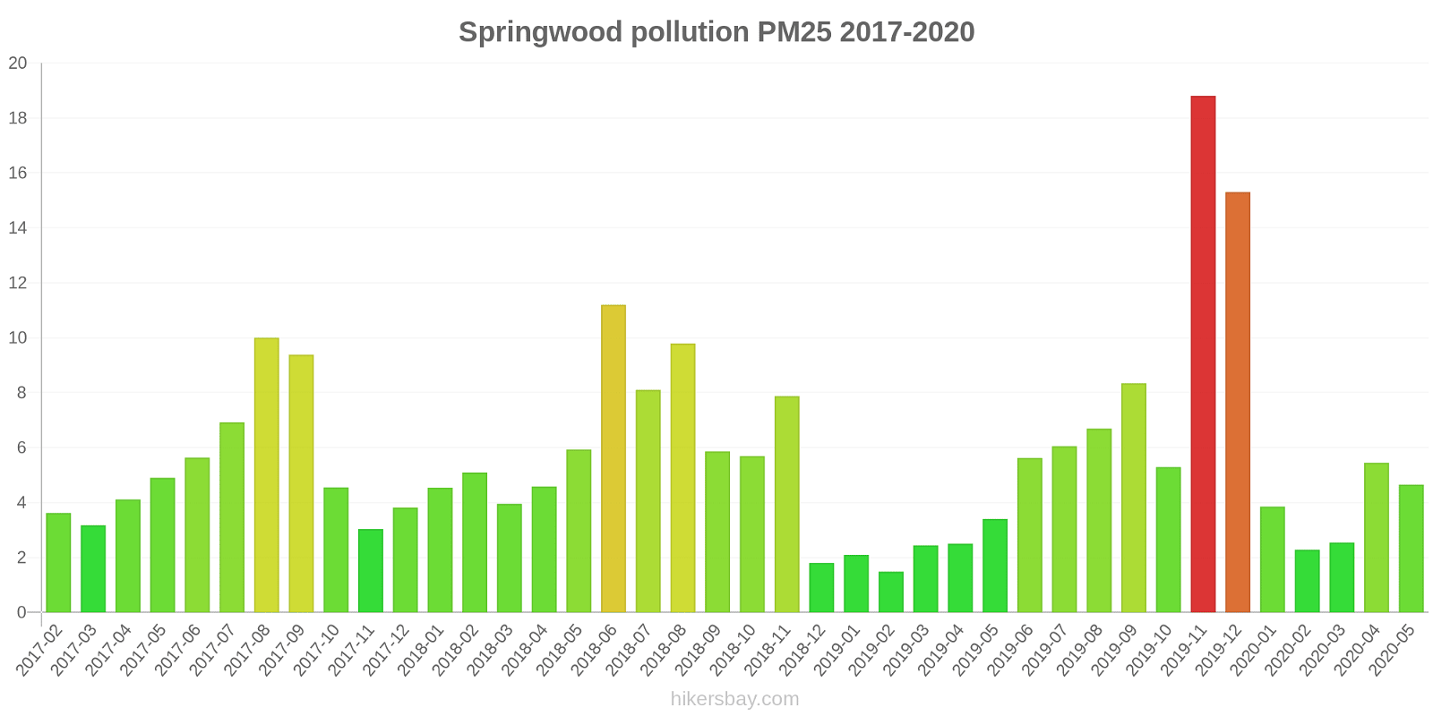
Springwood
2017-02 2020-05
index
2020-05
2020-04
2020-03
2020-02
2020-01
2019-12
2019-11
2019-10
2019-09
2019-08
2019-07
2019-06
2019-05
2019-04
2019-03
2019-02
2019-01
2018-12
2018-11
2018-10
2018-09
2018-08
2018-07
2018-06
2018-05
2018-04
2018-03
2018-02
2018-01
2017-12
2017-11
2017-10
2017-09
2017-08
2017-07
2017-06
2017-05
2017-04
2017-03
2017-02
no2:ppm
-
-
-
-
-
-
-
-
-
-
-
-
0.01
0.01
0
0
0
0.01
0.01
0.01
0.01
0.01
0.01
0.01
0.01
0.01
0
0.01
0
0
0
0
0.01
0.01
0.01
0.01
0.01
0.01
0
0
o3:ppm
0.02
0.02
0.02
0.01
0.01
0.02
0.01
0.01
0.02
0.02
0.01
0.01
0.01
0.01
0.02
0.01
0.01
0.01
0.02
-
-
0.02
0.02
0.02
0.03
0.02
0.01
0.01
0.01
0.01
0.02
0.02
0.02
0.02
0.01
0.01
0.01
0.02
0.02
0.02
so2:ppm
-
-
-
-
-
-
-
-
-
-
-
-
0
0
0
0
0
0
0
-
-
0
0
0
0
0
0
0
0
0
0
0
0
0
0
0
0
0
0
0
pm10
12
13
9.9
10
12
35
38
16
25
17
12
10
8.2
9.2
9.8
10
10
9.6
20
11
16
17
13
15
11
12
12
12
12
9.5
8.8
12
20
17
10
9.8
9.1
9.2
9.5
11
pm25
4.7
5.5
2.5
2.3
3.9
15
19
5.3
8.3
6.7
6
5.6
3.4
2.5
2.4
1.5
2.1
1.8
7.9
5.7
5.9
9.8
8.1
11
5.9
4.6
4
5.1
4.5
3.8
3
4.5
9.4
10
6.9
5.6
4.9
4.1
3.2
3.6
Woolloongabba
2017-06 2020-05

index
2020-05
2020-04
2020-03
2020-02
2020-01
2019-12
2019-11
2019-10
2019-09
2019-08
2019-07
2019-06
2019-05
2019-04
2019-03
2019-02
2019-01
2018-12
2018-11
2018-10
2018-09
2018-08
2018-07
2018-06
2018-05
2018-04
2018-03
2018-02
2018-01
2017-12
2017-11
2017-10
2017-09
2017-08
2017-07
2017-06
no2:ppm
-
-
-
-
-
-
-
-
-
-
-
-
0.02
0.01
0.01
0.01
0.01
0.01
0.01
0.02
0.02
0.02
0.02
0.02
0.02
0.02
0.01
0.01
0.01
0.01
0.02
0.02
0.02
0.02
0.02
0.02
co:ppm
-
-
-
-
-
-
-
-
-
-
-
-
0.29
0.28
0.3
0.42
0.18
0.16
0.09
0.19
0.26
0.26
0.24
0.16
0.23
0.14
0.17
0.18
0.07
0.1
0.13
0.13
0.09
0.18
0.18
0.17
pm10
17
17
14
15
19
41
46
22
32
21
18
28
12
12
15
13
16
21
30
20
25
22
21
15
16
15
16
17
16
14
14
17
24
22
15
20
pm25
6
6.3
5
5.5
8.2
19
24
8.4
11
7.7
8
23
6.5
5.2
7.1
5.6
6.1
8.2
13
12
10
11
15
8.6
7.4
6.8
7.3
8
6.7
6.7
6.6
8.7
12
13
9.5
11
Wynnum West
2017-02 2020-05
index
2020-05
2020-04
2020-03
2020-02
2020-01
2019-12
2019-11
2019-10
2019-09
2019-08
2019-07
2019-06
2019-05
2019-04
2019-03
2019-02
2019-01
2018-12
2018-11
2018-10
2018-09
2018-08
2018-07
2018-06
2018-05
2018-04
2018-03
2018-02
2018-01
2017-12
2017-11
2017-10
2017-09
2017-08
2017-07
2017-06
2017-05
2017-04
2017-03
2017-02
so2:ppm
-
-
-
-
-
-
-
-
-
-
-
-
0
-
-
-
-
0.01
0
0
0.01
0.01
0.01
0.01
0
0
0
0
0
0
0
0
0.01
0.01
0.01
0.01
0.01
0
0
0
pm10
12
12
10
11
13
34
38
17
31
20
15
10
11
9.1
12
12
12
17
23
11
17
18
16
11
13
12
12
11
13
11
9.9
16
24
22
12
11
11
9
9.5
4.9
pm25
3.3
4
2.2
2.5
4.8
12
15
4.3
7.8
5.5
5.2
3.7
2.9
2.1
3.3
2
2.5
4.7
4.5
3
3.6
6.4
5.5
3.8
3.4
2.6
2.5
3
2.8
2.9
2.3
4
7.2
7.9
4.7
3.6
3.5
2.5
5.6
2.5
Wynnum
2017-02 2020-05
index
2020-05
2020-04
2020-03
2020-02
2020-01
2019-12
2019-11
2019-10
2019-09
2019-08
2019-07
2019-06
2019-05
2019-04
2019-03
2019-02
2019-01
2018-12
2018-11
2018-10
2018-09
2018-08
2018-07
2018-06
2018-05
2018-04
2018-03
2018-02
2018-01
2017-12
2017-11
2017-10
2017-09
2017-08
2017-07
2017-06
2017-05
2017-04
2017-03
2017-02
no2:ppm
-
-
-
-
-
-
-
-
-
-
-
-
0
0
0
-
0
0
0
0
0.01
0.01
0.01
-
0.01
0.01
0
0
0
0
0
0
0.01
0.01
0.01
-
0.01
0.01
0
0
so2:ppm
-
-
-
-
-
-
-
-
-
-
-
-
0
0
0
-
0
0
0
0
0
0.01
0.01
-
0
0.01
0
0.43
0
0
0
0
0.01
0.01
0.01
-
0.01
0.01
0.01
0.01
pm25
3.2
3.6
2.4
2.3
4.2
11
15
4.1
8.3
5.1
4.9
3.8
3.2
2.4
4.1
2.6
3.3
5.3
5.5
3.5
4.3
7
5.8
4.1
4.1
3.5
3.1
5.9
3.1
3
2.4
3.6
7.5
8.3
4.5
3.4
3.6
2.7
2.3
2.7
pm10
12
12
11
12
14
33
38
17
34
21
16
11
12
10
13
12
12
19
26
12
20
21
15
12
15
13
13
11
14
11
10
15
26
24
14
11
11
11
11
12
Hopeland
2017-12 2020-05
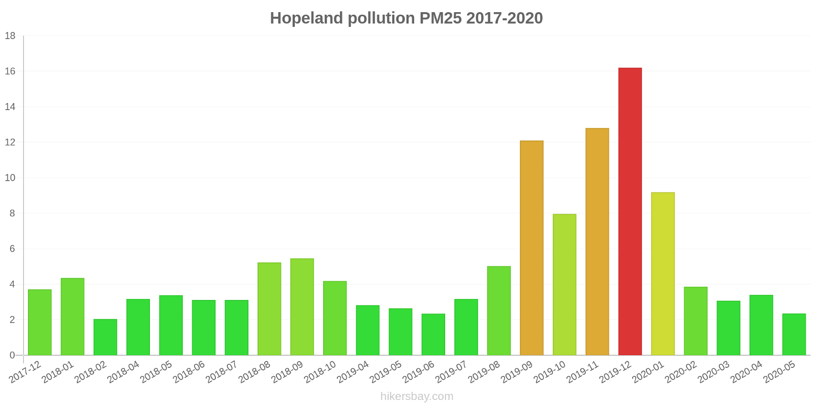
index
2020-05
2020-04
2020-03
2020-02
2020-01
2019-12
2019-11
2019-10
2019-09
2019-08
2019-07
2019-06
2019-05
2019-04
2019-03
2019-02
2019-01
2018-12
2018-11
2018-10
2018-09
2018-08
2018-07
2018-06
2018-05
2018-04
2018-03
2018-02
2018-01
2017-12
pm10
7.5
10
7.8
9.4
24
35
41
24
39
16
9
5.7
8.5
8.8
-
-
-
-
-
6.1
17
17
8.3
9.8
11
8.8
-
5.4
10
6.2
pm25
2.4
3.4
3.1
3.9
9.2
16
13
8
12
5
3.2
2.3
2.6
2.8
-
-
-
-
-
4.2
5.5
5.2
3.1
3.1
3.4
3.2
-
2
4.3
3.7
no2:ppm
-
-
-
-
-
-
-
-
-
-
-
-
-
-
-
-
-
-
-
-
0
0
-
-
0
-
0
0
0
-
o3:ppm
0.02
0.03
-
-
-
-
-
-
-
-
0.03
0.03
-
-
-
-
-
-
-
-
-
-
-
0.02
-
-
0.02
0.03
0.02
-
co:ppm
-
-
-
-
-
-
-
-
-
-
-
-
-
0.1
0.09
0.08
0.12
0.14
0.14
0.19
0.1
0.15
0.09
0.13
0.11
-
-
-
-
-
Miles Airport
2017-12 2020-05

index
2020-05
2020-04
2020-03
2020-02
2020-01
2019-12
2019-11
2019-10
2018-12
2018-11
2018-10
2018-09
2018-08
2018-07
2018-06
2018-05
2018-04
2018-03
2018-02
2018-01
2017-12
pm10
12
19
12
11
33
32
28
17
24
25
8.1
18
20
9.4
14
17
16
14
13
16
6.7
pm25
3.3
4.9
3.8
4.5
11
14
8
5.6
9.1
9.4
5.2
5.8
5.7
4.1
3.9
4.4
5
4.5
5.1
5.2
3.6
co:ppm
-
-
-
-
-
-
-
-
0.49
0.21
0.33
0.11
0.12
0.12
0.1
0.23
0.19
0.19
0.15
0.12
-
no2:ppm
-
-
-
-
-
-
-
-
-
-
-
0
0
-
-
0
-
0
0
0
-
o3:ppm
-
-
-
-
-
-
-
-
-
-
0.03
-
0.02
-
-
0.02
0.02
0.02
0.03
0.03
-
Coastguard
index
2020-05
2020-04
2020-03
2020-02
2020-01
2019-12
2019-11
2019-10
2019-09
2019-08
2019-07
2019-06
2019-05
2019-04
2019-03
2019-02
2019-01
2018-12
2018-11
2018-10
2018-09
2018-08
2018-07
2018-06
2018-05
2018-04
2018-03
2018-02
2018-01
2017-12
2017-11
2017-03
2017-02
pm10
16
15
15
14
16
19
27
21
34
21
17
16
17
16
11
4
20
18
19
11
16
18
17
18
17
17
16
13
17
13
18
11
15
Lennon Drive
index
2020-05
2020-04
2020-03
2020-02
2020-01
2019-12
2019-11
2019-10
2019-09
2019-08
2019-07
2019-06
2019-05
2019-04
2019-03
2019-02
2019-01
2018-12
2018-11
2018-10
2018-09
2018-08
2018-07
2018-06
pm10
18
17
15
13
15
17
22
22
33
21
19
16
17
18
12
23
21
23
20
13
19
18
19
23
North Ward
2018-03 2020-05
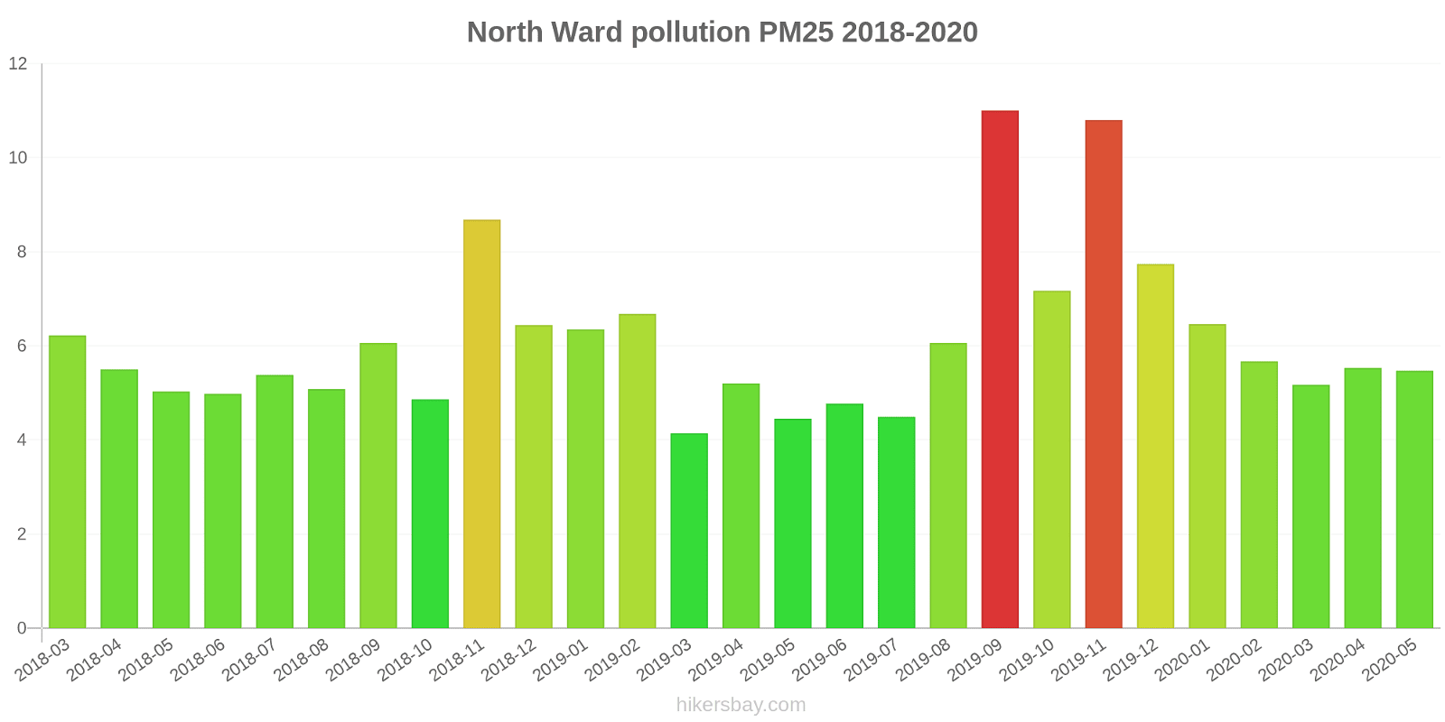
index
2020-05
2020-04
2020-03
2020-02
2020-01
2019-12
2019-11
2019-10
2019-09
2019-08
2019-07
2019-06
2019-05
2019-04
2019-03
2019-02
2019-01
2018-12
2018-11
2018-10
2018-09
2018-08
2018-07
2018-06
2018-05
2018-04
2018-03
no2:ppm
-
-
-
-
-
-
-
-
-
-
-
-
-
0
0
0
0
0
0
0
0
0
0
0
0
0
0
so2:ppm
-
-
-
-
-
-
-
-
-
-
-
-
-
-
-
-
-
-
-
0
0
0
-
0
0
0
0
pm10
16
16
15
16
17
19
29
23
30
18
13
14
14
16
11
23
17
16
19
14
16
15
13
14
14
15
15
pm25
5.5
5.5
5.2
5.7
6.5
7.7
11
7.2
11
6.1
4.5
4.8
4.5
5.2
4.1
6.7
6.3
6.4
8.7
4.9
6.1
5.1
5.4
5
5
5.5
6.2
Stuart
index
2018-11
2018-10
2018-09
2018-08
2018-07
2018-06
2018-05
2018-03
2018-02
2018-01
2017-12
2017-11
2017-10
2017-09
2017-08
2017-07
2017-06
2017-05
2017-04
2017-03
2017-02
so2:ppm
0
0
0
0
0
0
0
0
0
0
0
0
0
0
0
0
0
0
0
0
0
Menzies
index
2019-03
2019-02
2019-01
2018-12
2018-11
2018-10
2018-09
2018-08
2018-07
2018-06
2018-04
2018-03
2018-02
2018-01
2017-12
2017-11
2017-10
2017-09
2017-08
2017-07
2017-06
2017-05
2017-04
2017-03
2017-02
so2:ppm
0.01
0.01
0.01
0.01
0.01
0.01
0.01
0.01
0.01
0
0
0
0.02
0.01
0.01
0.02
0.01
0.02
0.01
0.02
0.01
0.01
0
0.01
0.01
The Gap
index
2020-05
2020-04
2020-03
2020-02
2020-01
2019-12
2019-11
2019-10
2019-09
2019-08
2019-07
2019-06
2019-05
2019-04
2019-03
2019-02
2019-01
2018-12
2018-11
2018-10
2018-09
2018-08
2018-07
2018-06
2018-05
2018-04
2018-03
2018-02
2018-01
2017-12
2017-11
2017-10
2017-09
2017-08
2017-07
2017-06
2017-05
2017-04
2017-03
2017-02
so2:ppm
-
-
-
-
-
-
-
-
-
-
-
-
0.01
0
0
0.01
0.01
0.01
0.02
0.01
0
0.01
0.01
0
-
-
-
0.06
0.02
0.02
0.01
0.01
0.01
0
0.01
-
0.01
-
0.01
0.01
pm10
19
19
14
34
33
36
53
35
48
25
17
14
13
18
64
28
21
28
28
41
33
31
21
18
17
16
9.5
19
16
21
18
18
28
19
15
16
17
16
17
13
* Pollution data source:
https://openaq.org
(Australia - Queensland, AirNow)
The data is licensed under CC-By 4.0
PM10 16 (Buono)
PM2,5 5 (Buono)
O3 -708 (Buono)
NO2 7 (Buono)
SO2 0 (Buono)
CO 100 (Buono)
Dati sull'inquinamento atmosferico degli ultimi giorni Queensland
| index | 2024-04-08 | 2024-04-09 | 2024-04-10 | 2024-04-11 | 2024-04-12 | 2024-04-13 | 2024-04-14 | 2024-04-15 | 2024-01-31 | 2024-02-02 | 2024-02-03 | 2024-02-04 | 2024-02-05 | 2024-02-06 | 2024-02-07 | 2023-06-11 | 2023-06-10 | 2023-06-07 | 2023-06-08 | 2023-06-06 | 2023-06-09 | 2023-06-05 | 2022-05-27 |
|---|---|---|---|---|---|---|---|---|---|---|---|---|---|---|---|---|---|---|---|---|---|---|---|
| pm10 | 11 Good |
14 Good |
16 Good |
17 Good |
18 Good |
15 Good |
15 Good |
15 Good |
18 Good |
17 Good |
18 Good |
18 Good |
22 Moderate |
18 Good |
32 Moderate |
9 Good |
6 Good |
7 Good |
6 Good |
6 Good |
4 Good |
6 Good |
27 Moderate |
| pm25 | 3 Good |
5 Good |
4 Good |
5 Good |
5 Good |
5 Good |
5 Good |
5 Good |
6 Good |
6 Good |
7 Good |
8 Good |
8 Good |
7 Good |
7 Good |
3 Good |
2 Good |
2 Good |
2 Good |
3 Good |
2 Good |
4 Good |
20 Moderate |
| o3 | 0 Good |
0 Good |
0 Good |
0 Good |
0 Good |
0 Good |
0 Good |
0 Good |
0 Good |
0 Good |
0 Good |
0 Good |
0 Good |
0 Good |
0 Good |
0 Good |
0 Good |
0 Good |
0 Good |
0 Good |
0 Good |
-227 Good |
39 Good |
| no2 | - Good |
- Good |
- Good |
- Good |
- Good |
- Good |
- Good |
- Good |
- Good |
- Good |
- Good |
- Good |
- Good |
- Good |
- Good |
- Good |
- Good |
- Good |
- Good |
- Good |
- Good |
- Good |
20 Good |
| so2 | - Good |
- Good |
- Good |
- Good |
- Good |
- Good |
- Good |
- Good |
- Good |
- Good |
- Good |
- Good |
- Good |
- Good |
- Good |
- Good |
- Good |
- Good |
- Good |
- Good |
- Good |
- Good |
5 Good |
| co | - Good |
- Good |
- Good |
- Good |
- Good |
- Good |
- Good |
- Good |
- Good |
- Good |
- Good |
- Good |
- Good |
- Good |
- Good |
- Good |
- Good |
- Good |
- Good |
- Good |
- Good |
- Good |
240 Good |
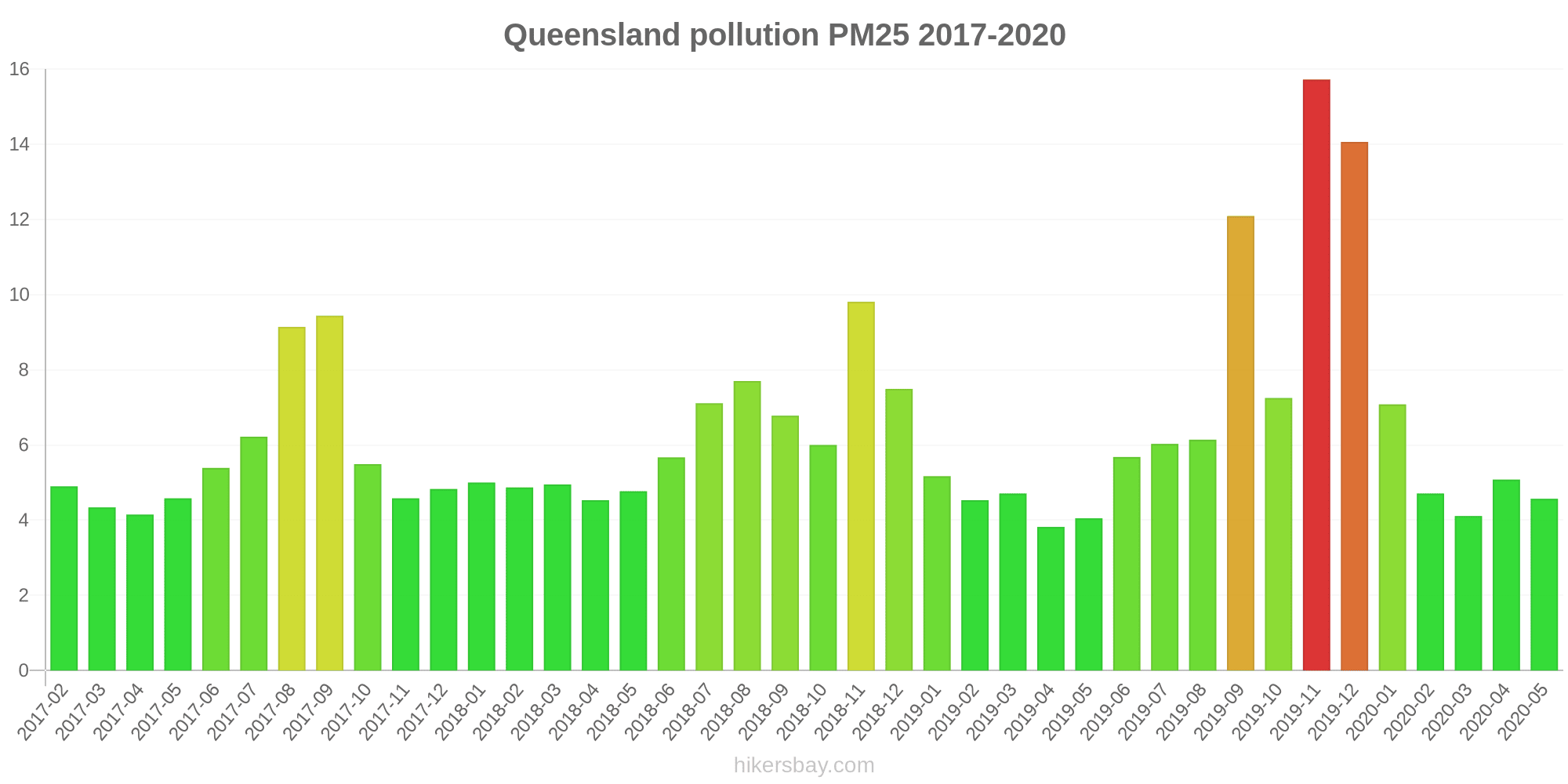
| index | 2020-05 | 2020-04 | 2020-03 | 2020-02 | 2020-01 | 2019-12 | 2019-11 | 2019-10 | 2019-09 | 2019-08 | 2019-07 | 2019-06 | 2019-05 | 2019-04 | 2019-03 | 2019-02 | 2019-01 | 2018-12 | 2018-11 | 2018-10 | 2018-09 | 2018-08 | 2018-07 | 2018-06 | 2018-05 | 2018-04 | 2018-03 | 2018-02 | 2018-01 | 2017-12 | 2017-11 | 2017-10 | 2017-09 | 2017-08 | 2017-07 | 2017-06 | 2017-05 | 2017-04 | 2017-03 | 2017-02 |
|---|---|---|---|---|---|---|---|---|---|---|---|---|---|---|---|---|---|---|---|---|---|---|---|---|---|---|---|---|---|---|---|---|---|---|---|---|---|---|---|---|
| pm10 | 16 (Good) | 16 (Good) | 14 (Good) | 15 (Good) | 19 (Good) | 34 (Moderate) | 38 (Moderate) | 22 (Moderate) | 35 (Moderate) | 19 (Good) | 16 (Good) | 14 (Good) | 14 (Good) | 14 (Good) | 16 (Good) | 18 (Good) | 18 (Good) | 21 (Moderate) | 25 (Moderate) | 15 (Good) | 21 (Moderate) | 20 (Moderate) | 16 (Good) | 15 (Good) | 16 (Good) | 15 (Good) | 15 (Good) | 14 (Good) | 16 (Good) | 14 (Good) | 14 (Good) | 16 (Good) | 25 (Moderate) | 22 (Moderate) | 14 (Good) | 15 (Good) | 14 (Good) | 15 (Good) | 13 (Good) | 16 (Good) |
| pm25 | 4.6 (Good) | 5.1 (Good) | 4.1 (Good) | 4.7 (Good) | 7.1 (Good) | 14 (Moderate) | 16 (Moderate) | 7.3 (Good) | 12 (Good) | 6.1 (Good) | 6 (Good) | 5.7 (Good) | 4 (Good) | 3.8 (Good) | 4.7 (Good) | 4.5 (Good) | 5.2 (Good) | 7.5 (Good) | 9.8 (Good) | 6 (Good) | 6.8 (Good) | 7.7 (Good) | 7.1 (Good) | 5.7 (Good) | 4.8 (Good) | 4.5 (Good) | 5 (Good) | 4.9 (Good) | 5 (Good) | 4.8 (Good) | 4.6 (Good) | 5.5 (Good) | 9.4 (Good) | 9.1 (Good) | 6.2 (Good) | 5.4 (Good) | 4.6 (Good) | 4.2 (Good) | 4.3 (Good) | 4.9 (Good) |
| o3:ppm | 0.02 (Good) | 0.02 (Good) | 0.02 (Good) | 0.02 (Good) | 0.02 (Good) | 0.03 (Good) | 0.03 (Good) | 0.02 (Good) | 0.02 (Good) | 0.02 (Good) | 0.02 (Good) | 0.02 (Good) | 0.02 (Good) | 0.02 (Good) | 0.02 (Good) | 0.02 (Good) | 0.02 (Good) | 0.02 (Good) | 0.02 (Good) | 0.03 (Good) | 0.02 (Good) | 0.02 (Good) | 0.02 (Good) | 0.02 (Good) | 0.02 (Good) | 0.02 (Good) | 0.02 (Good) | 0.02 (Good) | 0.02 (Good) | 0.02 (Good) | 0.02 (Good) | 0.03 (Good) | 0.03 (Good) | 0.02 (Good) | 0.02 (Good) | 0.02 (Good) | 0.02 (Good) | 0.02 (Good) | 0.02 (Good) | 0.02 (Good) |
| no2:ppm | - (Good) | - (Good) | - (Good) | - (Good) | - (Good) | - (Good) | - (Good) | - (Good) | - (Good) | - (Good) | - (Good) | - (Good) | 0.01 (Good) | 0.01 (Good) | 0 (Good) | 0 (Good) | 0 (Good) | 0 (Good) | 0.01 (Good) | 0.01 (Good) | 0.01 (Good) | 0.01 (Good) | 0.01 (Good) | 0.01 (Good) | 0.01 (Good) | 0.01 (Good) | 0 (Good) | 0 (Good) | 0 (Good) | 0 (Good) | 0 (Good) | 0.01 (Good) | 0.01 (Good) | 0.01 (Good) | 0.01 (Good) | 0.01 (Good) | 0.01 (Good) | 0.01 (Good) | 0 (Good) | 0 (Good) |
| so2:ppm | - (Good) | - (Good) | - (Good) | - (Good) | - (Good) | - (Good) | - (Good) | - (Good) | - (Good) | - (Good) | - (Good) | - (Good) | 0 (Good) | 0 (Good) | 0 (Good) | 0.01 (Good) | 0 (Good) | 0 (Good) | 0.01 (Good) | 0 (Good) | 0 (Good) | 0 (Good) | 0 (Good) | 0 (Good) | 0 (Good) | 0 (Good) | 0 (Good) | 0.04 (Good) | 0 (Good) | 0 (Good) | 0.01 (Good) | 0 (Good) | 0.01 (Good) | 0 (Good) | 0.01 (Good) | 0 (Good) | 0 (Good) | 0 (Good) | 0 (Good) | 0 (Good) |
| co:ppm | - (Good) | - (Good) | - (Good) | - (Good) | - (Good) | - (Good) | - (Good) | - (Good) | - (Good) | - (Good) | - (Good) | - (Good) | 0.29 (Good) | 0.15 (Good) | 0.2 (Good) | 0.25 (Good) | 0.15 (Good) | 0.26 (Good) | 0.14 (Good) | 0.23 (Good) | 0.25 (Good) | 0.35 (Good) | 0.31 (Good) | 0.26 (Good) | 0.28 (Good) | 0.32 (Good) | 0.31 (Good) | 0.3 (Good) | 0.23 (Good) | 0.3 (Good) | 0.29 (Good) | 0.3 (Good) | 0.43 (Good) | 0.78 (Good) | 0.39 (Good) | 0.13 (Good) | 0.2 (Good) | 0.28 (Good) | 0.34 (Good) | 0.35 (Good) |
Verde e parchi in città
Queensland 71%
Timor Est: 53% Papua Nuova Guinea: 27% Nuova Caledonia: 70%particolato PM2.5
Queensland 6.8 (Good)
Il piacere di trascorrere del tempo in città
Queensland 73%
Timor Est: 44% Papua Nuova Guinea: 34%particolato PM10
Queensland 16 (Good)
Inquinamento dell'aria
Queensland 25%
Timor Est: 36% Papua Nuova Guinea: 63% Nuova Caledonia: 55%Smaltimento dei rifiuti
Queensland 65%
Timor Est: 19% Papua Nuova Guinea: 18% Nuova Caledonia: 30%Disponibilità e qualità dell'acqua potabile
Queensland 72%
Timor Est: 38% Papua Nuova Guinea: 38% Nuova Caledonia: 75%Pulizia e ordine
Queensland 64%
Timor Est: 25% Papua Nuova Guinea: 22% Nuova Caledonia: 30%Rumore e inquinamento luminoso
Queensland 36%
Timor Est: 53% Papua Nuova Guinea: 58% Nuova Caledonia: 45%Inquinamento delle acque
Queensland 40%
Timor Est: 64% Papua Nuova Guinea: 76% Nuova Caledonia: 55%PM10 21 (Moderata)
polveri sospese di particolato (PM10)PM2,5 5 (Buono)
polvere di particolato (PM2.5)PM10 18 (Buono)
polveri sospese di particolato (PM10)PM10 14 (Buono)
polveri sospese di particolato (PM10)PM2,5 5 (Buono)
polvere di particolato (PM2.5)PM2,5 4.8 (Buono)
polvere di particolato (PM2.5)PM10 16 (Buono)
polveri sospese di particolato (PM10)PM10 21 (Moderata)
polveri sospese di particolato (PM10)PM2,5 6.5 (Buono)
polvere di particolato (PM2.5)O3 0.02 (Buono)
ozono (O3)PM10 16 (Buono)
polveri sospese di particolato (PM10)PM2,5 5.3 (Buono)
polvere di particolato (PM2.5)PM10 13 (Buono)
polveri sospese di particolato (PM10)PM2,5 4.6 (Buono)
polvere di particolato (PM2.5)PM10 14 (Buono)
polveri sospese di particolato (PM10)PM2,5 4.2 (Buono)
polvere di particolato (PM2.5)PM10 15 (Buono)
polveri sospese di particolato (PM10)PM2,5 4.3 (Buono)
polvere di particolato (PM2.5)PM10 15 (Buono)
polveri sospese di particolato (PM10)PM2,5 5 (Buono)
polvere di particolato (PM2.5)PM2,5 5.2 (Buono)
polvere di particolato (PM2.5)PM10 16 (Buono)
polveri sospese di particolato (PM10)O3 0 (Buono)
ozono (O3)PM2,5 5.8 (Buono)
polvere di particolato (PM2.5)PM10 17 (Buono)
polveri sospese di particolato (PM10)O3 0.01 (Buono)
ozono (O3)PM10 13 (Buono)
polveri sospese di particolato (PM10)PM2,5 4.6 (Buono)
polvere di particolato (PM2.5)O3 0 (Buono)
ozono (O3)PM10 15 (Buono)
polveri sospese di particolato (PM10)PM2,5 5 (Buono)
polvere di particolato (PM2.5)PM10 20 (Moderata)
polveri sospese di particolato (PM10)PM2,5 3.9 (Buono)
polvere di particolato (PM2.5)PM10 12 (Buono)
polveri sospese di particolato (PM10)PM2,5 4.4 (Buono)
polvere di particolato (PM2.5)O3 0 (Buono)
ozono (O3)O3 0.02 (Buono)
ozono (O3)PM10 60 (Non integro per i gruppi sensibili)
polveri sospese di particolato (PM10)PM2,5 11 (Buono)
polvere di particolato (PM2.5)O3 0 (Buono)
ozono (O3)PM2,5 5.7 (Buono)
polvere di particolato (PM2.5)PM10 14 (Buono)
polveri sospese di particolato (PM10)PM2,5 4.9 (Buono)
polvere di particolato (PM2.5)O3 0.01 (Buono)
ozono (O3)PM10 13 (Buono)
polveri sospese di particolato (PM10)PM10 17 (Buono)
polveri sospese di particolato (PM10)PM2,5 5.6 (Buono)
polvere di particolato (PM2.5)PM2,5 4.5 (Buono)
polvere di particolato (PM2.5)O3 0.01 (Buono)
ozono (O3)PM10 13 (Buono)
polveri sospese di particolato (PM10)O3 0.01 (Buono)
ozono (O3)PM10 14 (Buono)
polveri sospese di particolato (PM10)PM2,5 5 (Buono)
polvere di particolato (PM2.5)PM2,5 4.8 (Buono)
polvere di particolato (PM2.5)PM10 17 (Buono)
polveri sospese di particolato (PM10)PM10 8.9 (Buono)
polveri sospese di particolato (PM10)PM2,5 2.4 (Buono)
polvere di particolato (PM2.5)PM2,5 2.3 (Buono)
polvere di particolato (PM2.5)PM10 7.7 (Buono)
polveri sospese di particolato (PM10)PM10 6.6 (Buono)
polveri sospese di particolato (PM10)PM2,5 3.6 (Buono)
polvere di particolato (PM2.5)O3 0.02 (Buono)
ozono (O3)PM10 7.7 (Buono)
polveri sospese di particolato (PM10)O3 -9999 (Buono)
ozono (O3)PM2,5 4.5 (Buono)
polvere di particolato (PM2.5)NO2 7.3 (Buono)
biossido di azoto (NO2)PM10 19 (Buono)
polveri sospese di particolato (PM10)O3 91 (Moderata)
ozono (O3)PM2,5 10 (Buono)
polvere di particolato (PM2.5)SO2 0.1 (Buono)
biossido di zolfo (SO2)CO 100 (Buono)
monossido di carbonio (CO)PM10 18 (Buono)
polveri sospese di particolato (PM10)PM10 16 (Buono)
polveri sospese di particolato (PM10)PM10 18 (Buono)
polveri sospese di particolato (PM10)PM10 18 (Buono)
polveri sospese di particolato (PM10)PM2,5 5.5 (Buono)
polvere di particolato (PM2.5)PM2,5 3.6 (Buono)
polvere di particolato (PM2.5)PM10 11 (Buono)
polveri sospese di particolato (PM10)O3 0.05 (Buono)
ozono (O3)PM2,5 4.7 (Buono)
polvere di particolato (PM2.5)PM10 15 (Buono)
polveri sospese di particolato (PM10)Auckland Point
| index | 2024-04-15 | 2024-04-14 | 2024-04-13 | 2024-04-12 | 2024-04-11 | 2024-04-10 | 2024-04-09 | 2024-04-08 |
|---|---|---|---|---|---|---|---|---|
| pm10 | 21 | 17 | 21 | 44 | 41 | 14 | 12 | 7.4 |
Boat Creek
| index | 2024-04-15 | 2024-04-14 | 2024-04-13 | 2024-04-12 | 2024-04-11 | 2024-04-10 | 2024-04-09 | 2024-04-08 |
|---|---|---|---|---|---|---|---|---|
| pm25 | 5 | 5.2 | 5.4 | 5.9 | 3.2 | 4.8 | 5.7 | 3.7 |
| pm10 | 16 | 17 | 18 | 19 | 15 | 22 | 19 | 16 |
Boyne Island
| index | 2024-04-15 | 2024-04-14 | 2024-04-13 | 2024-04-12 | 2024-04-11 | 2024-04-10 | 2024-04-09 | 2024-04-08 |
|---|---|---|---|---|---|---|---|---|
| pm10 | 14 | 15 | 15 | 16 | 11 | 12 | 12 | 9.9 |
| pm25 | 5.2 | 5.3 | 5.1 | 5.9 | 3.1 | 3.8 | 4.6 | 2.6 |
Clinton
| index | 2024-04-15 | 2024-04-14 | 2024-04-13 | 2024-04-12 | 2024-04-11 | 2024-04-10 | 2024-04-09 | 2024-04-08 |
|---|---|---|---|---|---|---|---|---|
| pm25 | 4.9 | 4.9 | 5.2 | 5.9 | 3.2 | 4.3 | 5 | 2.5 |
| pm10 | 16 | 14 | 17 | 19 | 12 | 13 | 13 | 8.6 |
Fisherman's Landing
| index | 2024-04-15 | 2024-04-14 | 2024-04-13 | 2024-04-12 | 2024-04-11 | 2024-04-10 | 2024-04-09 | 2024-04-08 |
|---|---|---|---|---|---|---|---|---|
| pm10 | 23 | 21 | 18 | 20 | 27 | 36 | 25 | 10 |
| pm25 | 6.7 | 6.1 | 6 | 7.6 | 8.4 | 10 | 8.9 | 4.1 |
Memorial Park
| index | 2024-04-15 | 2024-04-14 | 2024-04-13 | 2024-04-12 | 2024-04-11 | 2024-04-10 | 2024-04-09 | 2024-04-08 |
|---|---|---|---|---|---|---|---|---|
| o3 | 0.02 | 0.02 | 0.02 | 0.03 | 0.03 | 0.03 | 0.03 | 0.02 |
South Gladstone
| index | 2024-04-15 | 2024-04-14 | 2024-04-13 | 2024-04-12 | 2024-04-11 | 2024-04-10 | 2024-04-09 | 2024-04-08 |
|---|---|---|---|---|---|---|---|---|
| pm10 | 16 | 17 | 17 | 19 | 12 | 13 | 13 | 9.3 |
| pm25 | 5.3 | 5.5 | 5.5 | 6.3 | 3.3 | 4.2 | 5 | 2.7 |
Targinie
| index | 2024-04-15 | 2024-04-14 | 2024-04-13 | 2024-04-12 | 2024-04-11 | 2024-04-10 | 2024-04-09 | 2024-04-08 |
|---|---|---|---|---|---|---|---|---|
| pm10 | 13 | 14 | 14 | 15 | 10 | 12 | 13 | 11 |
| pm25 | 4.6 | 4.8 | 4.8 | 5.4 | 2.7 | 3.8 | 4.7 | 2.7 |
Blackwater
| index | 2024-04-15 | 2024-04-14 | 2024-04-13 | 2024-04-12 | 2024-04-11 | 2024-04-10 | 2024-04-09 | 2024-04-08 |
|---|---|---|---|---|---|---|---|---|
| pm10 | 14 | 13 | 15 | 17 | 20 | 27 | 21 | 12 |
| pm25 | 4.5 | 4.5 | 5 | 4.1 | 3.9 | 5.8 | 5.7 | 3.4 |
Emerald
| index | 2024-04-15 | 2024-04-14 | 2024-04-13 | 2024-04-12 | 2024-04-11 | 2024-04-10 | 2024-04-09 | 2024-04-08 |
|---|---|---|---|---|---|---|---|---|
| pm10 | 15 | 15 | 17 | 16 | 13 | 15 | 14 | 9.7 |
| pm25 | 4.4 | 4.6 | 5.1 | 3.8 | 2.8 | 4.7 | 5.5 | 3.2 |
West Mackay
| index | 2024-04-15 | 2024-04-14 | 2024-04-13 | 2024-04-12 | 2024-04-11 | 2024-04-10 | 2024-04-09 | 2024-04-08 |
|---|---|---|---|---|---|---|---|---|
| pm10 | 14 | 15 | 17 | 17 | 18 | 20 | 18 | 18 |
| pm25 | 4.8 | 5 | 5.8 | 4.7 | 4 | 5.3 | 4.7 | 4.5 |
Brisbane CBD
| index | 2024-04-15 | 2024-04-14 | 2024-04-13 | 2024-04-12 | 2024-04-11 | 2024-04-10 | 2024-04-09 | 2024-04-08 |
|---|---|---|---|---|---|---|---|---|
| pm25 | 5.3 | 5.6 | 5.4 | 5.5 | 4.2 | 3.7 | 4.8 | 4 |
| pm10 | 16 | 15 | 15 | 16 | 13 | 12 | 13 | 12 |
Cannon Hill
| index | 2024-04-15 | 2024-04-14 | 2024-04-13 | 2024-04-12 | 2024-04-11 | 2024-04-10 | 2024-04-09 | 2024-04-08 |
|---|---|---|---|---|---|---|---|---|
| pm10 | 16 | 14 | 14 | 16 | 21 | 18 | 14 | 13 |
| pm25 | 5.8 | 5.8 | 5.3 | 5.5 | 4.8 | 3.9 | 4.8 | 3.9 |
| o3 | 0.01 | 0.01 | 0.01 | 0.01 | 0.02 | 0.02 | 0.02 | 0.02 |
Deception Bay
| index | 2024-04-15 | 2024-04-14 | 2024-04-13 | 2024-04-12 | 2024-04-11 | 2024-04-10 | 2024-04-09 | 2024-04-08 |
|---|---|---|---|---|---|---|---|---|
| pm25 | 4.8 | 5.3 | 5 | 5.4 | 4.3 | 3.5 | 4.6 | 3.8 |
| pm10 | 13 | 15 | 14 | 15 | 13 | 12 | 13 | 12 |
| o3 | 0.02 | 0.02 | 0.02 | 0.02 | 0.02 | 0.02 | 0.02 | 0.03 |
Flinders View
| index | 2024-04-15 | 2024-04-14 | 2024-04-13 | 2024-04-12 | 2024-04-11 | 2024-04-10 | 2024-04-09 | 2024-04-08 |
|---|---|---|---|---|---|---|---|---|
| pm25 | 5.2 | 5.6 | 5.3 | 4.9 | 4 | 3.6 | 4.8 | 3.9 |
| pm10 | 14 | 14 | 14 | 14 | 12 | 12 | 13 | 11 |
| o3 | 0.02 | 0.02 | 0.01 | 0.01 | 0.01 | 0.02 | 0.02 | 0.02 |
Lytton
| index | 2024-04-15 | 2024-04-14 | 2024-04-13 | 2024-04-12 | 2024-04-11 | 2024-04-10 | 2024-04-09 | 2024-04-08 |
|---|---|---|---|---|---|---|---|---|
| pm10 | 20 | 13 | 14 | 23 | 28 | 24 | 18 | 18 |
| pm25 | 4 | 3.4 | 3.1 | 4.5 | 5 | 3.3 | 2.7 | 3.3 |
Mountain Creek
| index | 2024-04-15 | 2024-04-14 | 2024-04-13 | 2024-04-12 | 2024-04-11 | 2024-04-10 | 2024-04-09 | 2024-04-08 |
|---|---|---|---|---|---|---|---|---|
| o3 | 0.01 | 0.01 | 0.01 | 0.02 | 0.02 | 0.02 | 0.03 | 0.02 |
| pm25 | 4.6 | 5 | 5.3 | 6.2 | 4.2 | 3.3 | 4.4 | 3.5 |
| pm10 | 12 | 12 | 14 | 17 | 13 | 12 | 12 | 12 |
Mutdapilly
| index | 2024-02-07 | 2024-02-06 | 2024-02-05 | 2024-02-04 | 2024-02-03 | 2024-02-02 | 2024-01-31 |
|---|---|---|---|---|---|---|---|
| o3 | 0.01 | 0.01 | 0.02 | 0.02 | 0.02 | 0.01 | 0.01 |
| pm25 | 9.7 | 7.5 | 9.3 | 7.2 | 6.9 | 6 | 6 |
| pm10 | 50 | 22 | 26 | 19 | 23 | 21 | 19 |
North Maclean
| index | 2024-04-15 | 2024-04-14 | 2024-04-13 | 2024-04-12 | 2024-04-11 | 2024-04-10 | 2024-04-09 | 2024-04-08 |
|---|---|---|---|---|---|---|---|---|
| pm10 | 14 | 17 | 15 | 14 | 12 | 12 | 11 | 12 |
| pm25 | 5.8 | 7.6 | 6.2 | 5.5 | 4.5 | 3.6 | 4 | 4 |
| o3 | 0.02 | 0.01 | 0.01 | 0.01 | 0.01 | 0.01 | 0.03 | 0.02 |
Rocklea
| index | 2024-02-07 | 2024-02-06 | 2024-02-05 | 2024-02-04 | 2024-02-03 | 2024-02-02 | 2024-01-31 |
|---|---|---|---|---|---|---|---|
| o3 | 0.01 | 0.01 | 0.01 | 0.01 | 0.01 | 0.01 | 0.01 |
| pm10 | 13 | 14 | 18 | 17 | 13 | 13 | 17 |
| pm25 | 5.1 | 5.8 | 6.8 | 8.6 | 6.4 | 5.5 | 6.7 |
South Brisbane
| index | 2024-04-15 | 2024-04-14 | 2024-04-13 | 2024-04-12 | 2024-04-11 | 2024-04-10 | 2024-04-09 | 2024-04-08 |
|---|---|---|---|---|---|---|---|---|
| pm10 | 16 | 15 | 16 | 18 | 15 | 14 | 15 | 13 |
| pm25 | 5.7 | 5.9 | 5.8 | 6 | 4.7 | 4.4 | 5.7 | 4.5 |
Southport
| index | 2024-04-15 | 2024-04-14 | 2024-04-13 | 2024-04-12 | 2024-04-11 | 2024-04-10 | 2024-04-09 | 2024-04-08 |
|---|---|---|---|---|---|---|---|---|
| pm10 | 13 | 14 | 14 | 16 | 14 | 11 | 15 | 14 |
| o3 | 0.02 | 0.01 | 0.01 | 0.01 | 0.02 | 0.02 | 0.02 | 0.02 |
| pm25 | 4.7 | 5.3 | 5.1 | 5.6 | 4.4 | 3.7 | 5.2 | 4.3 |
Springwood
| index | 2024-04-15 | 2024-04-14 | 2024-04-13 | 2024-04-12 | 2024-04-11 | 2024-04-10 | 2024-04-09 | 2024-04-08 |
|---|---|---|---|---|---|---|---|---|
| pm25 | 5.2 | 5.8 | 5.4 | 5.8 | 4.4 | 3.9 | 4.9 | 3.9 |
| o3 | 0.02 | 0.01 | 0.01 | 0.02 | 0.02 | 0.02 | 0.02 | 0.02 |
| pm10 | 14 | 14 | 15 | 18 | 15 | 14 | 14 | 13 |
Woolloongabba
| index | 2024-04-15 | 2024-04-14 | 2024-04-13 | 2024-04-12 | 2024-04-11 | 2024-04-10 | 2024-04-09 | 2024-04-08 |
|---|---|---|---|---|---|---|---|---|
| pm25 | 5.1 | 5 | 5.1 | 5.5 | 4.7 | 4 | 4.8 | 4 |
| pm10 | 16 | 14 | 16 | 21 | 22 | 21 | 20 | 16 |
Wynnum West
| index | 2024-04-15 | 2024-04-14 | 2024-04-13 | 2024-04-12 | 2024-04-11 | 2024-04-10 | 2024-04-09 | 2024-04-08 |
|---|---|---|---|---|---|---|---|---|
| pm10 | 9.4 | 9.7 | 9.8 | 13 | 11 | 14 | 14 | 10 |
| pm25 | 2.6 | 2.8 | 2.4 | 2.9 | 2.7 | 2.1 | 2.5 | 2.2 |
Deception Bay
| index | 2024-04-15 | 2024-04-14 | 2024-04-13 | 2024-04-12 | 2024-04-11 | 2024-04-10 | 2024-04-09 | 2024-04-08 |
|---|---|---|---|---|---|---|---|---|
| pm25 | 2.5 | 2.5 | 2.3 | 2.9 | 3 | 2.4 | 2.5 | 2.4 |
| pm10 | 8.1 | 8.6 | 8.8 | 12 | 12 | 17 | 16 | 9.1 |
Hopeland
| index | 2023-06-05 | 2023-06-09 | 2023-06-06 | 2023-06-08 | 2023-06-07 | 2023-06-10 | 2023-06-11 |
|---|---|---|---|---|---|---|---|
| pm10 | 5.7 | 4 | 5.5 | 5.5 | 6.5 | 5.9 | 8.5 |
| pm25 | 3.2 | 1.7 | 2.5 | 2.1 | 2.4 | 2.1 | 3 |
| o3 | 0.02 | 0.02 | 0.02 | 0.02 | 0.02 | 0.01 | 0.01 |
Miles Airport
| index | 2023-06-05 | 2023-06-09 | 2023-06-06 | 2023-06-08 | 2023-06-07 | 2023-06-10 | 2023-06-11 |
|---|---|---|---|---|---|---|---|
| pm10 | 7.1 | 4.2 | 6.9 | 7.4 | 7.2 | 6 | 8.8 |
| o3 | -454.48 | 0.02 | 0.01 | 0.02 | 0.02 | 0.02 | 0.01 |
| pm25 | 4.2 | 1.6 | 3.1 | 2.3 | 2.3 | 1.9 | 3.2 |
Upper Humbug
| index | 2022-05-27 |
|---|---|
| no2 | 20 |
| pm10 | 27 |
| o3 | 39 |
| pm25 | 20 |
| so2 | 4.9 |
| co | 240 |
Coastguard
| index | 2024-04-15 | 2024-04-14 | 2024-04-13 | 2024-04-12 | 2024-04-11 | 2024-04-10 | 2024-04-09 | 2024-04-08 |
|---|---|---|---|---|---|---|---|---|
| pm10 | 18 | 19 | 18 | 17 | 19 | 16 | 9.5 | 7.1 |
Environment Park
| index | 2024-04-15 | 2024-04-14 | 2024-04-13 | 2024-04-12 | 2024-04-11 | 2024-04-10 | 2024-04-09 | 2024-04-08 |
|---|---|---|---|---|---|---|---|---|
| pm10 | 17 | 17 | 15 | 15 | 18 | 14 | 9.6 | 10 |
Lennon Drive
| index | 2024-04-15 | 2024-04-14 | 2024-04-13 | 2024-04-12 | 2024-04-11 | 2024-04-10 | 2024-04-09 | 2024-04-08 |
|---|---|---|---|---|---|---|---|---|
| pm10 | 18 | 18 | 19 | 18 | 19 | 16 | 9.6 | 7.5 |
North Ward
| index | 2024-04-15 | 2024-04-14 | 2024-04-13 | 2024-04-12 | 2024-04-11 | 2024-04-10 | 2024-04-09 | 2024-04-08 |
|---|---|---|---|---|---|---|---|---|
| pm10 | 18 | 19 | 18 | 17 | 20 | 18 | 10 | 7.5 |
| pm25 | 5.6 | 6.3 | 5.7 | 5.1 | 8 | 6.3 | 4 | 2.9 |
Stuart
| index | 2024-04-15 | 2024-04-14 | 2024-04-13 | 2024-04-12 | 2024-04-11 | 2024-04-10 | 2024-04-09 | 2024-04-08 |
|---|---|---|---|---|---|---|---|---|
| pm10 | 12 | 12 | 17 | 19 | 36 | 18 | 15 | 8.8 |
| pm25 | 4 | 4.1 | 5.8 | 7.3 | 13 | 7.5 | 4.5 | 3 |
| o3 | 0.04 | 0.04 | 0.05 | 0.04 | 0.04 | 0.05 | 0.05 | 0.05 |
The Gap
| index | 2024-04-15 | 2024-04-14 | 2024-04-13 | 2024-04-12 | 2024-04-11 | 2024-04-10 | 2024-04-09 | 2024-04-08 |
|---|---|---|---|---|---|---|---|---|
| pm25 | 4.3 | 4.4 | 3.9 | 2.7 | 2.4 | 3.1 | 4.1 | 4.2 |
| pm10 | 13 | 13 | 13 | 11 | 9.9 | 11 | 13 | 10 |
Auckland Point
| index | 2020-05 | 2020-04 | 2020-03 | 2020-02 | 2020-01 | 2019-12 | 2019-11 | 2019-10 | 2019-09 | 2019-08 | 2019-07 | 2019-06 | 2019-05 | 2019-04 | 2019-03 | 2019-02 | 2019-01 | 2018-12 | 2018-11 | 2018-10 | 2018-09 | 2018-08 | 2018-07 | 2018-06 | 2018-05 | 2018-04 | 2018-03 | 2018-02 | 2018-01 | 2017-12 | 2017-11 | 2017-10 | 2017-09 | 2017-08 | 2017-07 | 2017-06 | 2017-05 | 2017-04 | 2017-03 | 2017-02 |
|---|---|---|---|---|---|---|---|---|---|---|---|---|---|---|---|---|---|---|---|---|---|---|---|---|---|---|---|---|---|---|---|---|---|---|---|---|---|---|---|---|
| pm10 | 19 | 28 | 23 | 14 | 17 | 31 | 34 | 22 | 31 | 15 | 16 | 14 | 15 | 18 | 13 | 19 | 24 | 25 | 33 | 17 | 23 | 18 | 16 | 16 | 18 | 24 | 12 | 20 | 20 | 16 | 18 | 20 | 23 | 19 | 15 | 16 | 16 | 18 | 16 | 21 |
Boat Creek

| index | 2020-05 | 2020-04 | 2020-03 | 2020-02 | 2020-01 | 2019-12 | 2019-11 | 2019-10 | 2019-09 | 2019-08 | 2019-07 | 2019-06 | 2019-05 | 2019-04 | 2019-03 | 2019-02 | 2019-01 | 2018-12 | 2018-11 | 2018-10 | 2018-09 | 2018-08 | 2018-07 | 2018-06 | 2018-05 | 2018-04 | 2018-03 | 2018-02 | 2018-01 | 2017-12 | 2017-11 | 2017-10 | 2017-09 | 2017-08 | 2017-07 | 2017-06 | 2017-05 | 2017-04 | 2017-03 | 2017-02 |
|---|---|---|---|---|---|---|---|---|---|---|---|---|---|---|---|---|---|---|---|---|---|---|---|---|---|---|---|---|---|---|---|---|---|---|---|---|---|---|---|---|
| no2:ppm | - | - | - | - | - | - | - | - | - | - | - | - | 0 | 0 | 0 | 0 | 0 | 0 | 0 | 0 | 0.01 | 0.01 | 0 | 0 | 0 | 0 | 0 | 0 | 0 | 0 | 0 | 0 | 0.01 | 0.01 | 0.01 | 0.01 | 0.01 | 0 | 0 | 0 |
| so2:ppm | - | - | - | - | - | - | - | - | - | - | - | - | 0 | 0 | 0 | 0 | 0 | 0 | 0 | 0 | 0 | 0 | 0 | 0 | 0 | 0 | 0 | 0 | 0 | 0 | 0 | 0 | 0 | 0 | 0 | 0 | 0 | 0 | 0 | 0 |
| pm10 | 15 | 15 | 15 | 15 | 17 | 33 | 33 | 23 | 39 | 16 | 17 | 14 | 15 | 16 | 11 | 14 | 16 | 24 | 28 | 13 | 17 | 13 | 11 | 11 | 12 | 14 | 13 | 13 | 16 | 13 | 17 | 13 | 19 | 16 | 9.5 | 12 | 12 | 13 | 12 | 16 |
| pm25 | 4.3 | 4.9 | 4.7 | 5.9 | 7.2 | 13 | 13 | 8.8 | 20 | 5.1 | 6.4 | 4.7 | 4.5 | 5 | 3.6 | 3.6 | 4.3 | 11 | 13 | 5.4 | 4.8 | 5 | 3.8 | 3.4 | 4.5 | 5.2 | 3.6 | 4.4 | 4.3 | 4.5 | 8 | 5 | 7.8 | 7.7 | 3.2 | 4.1 | 3.5 | 3.2 | 3.7 | 4.8 |
Boyne Island
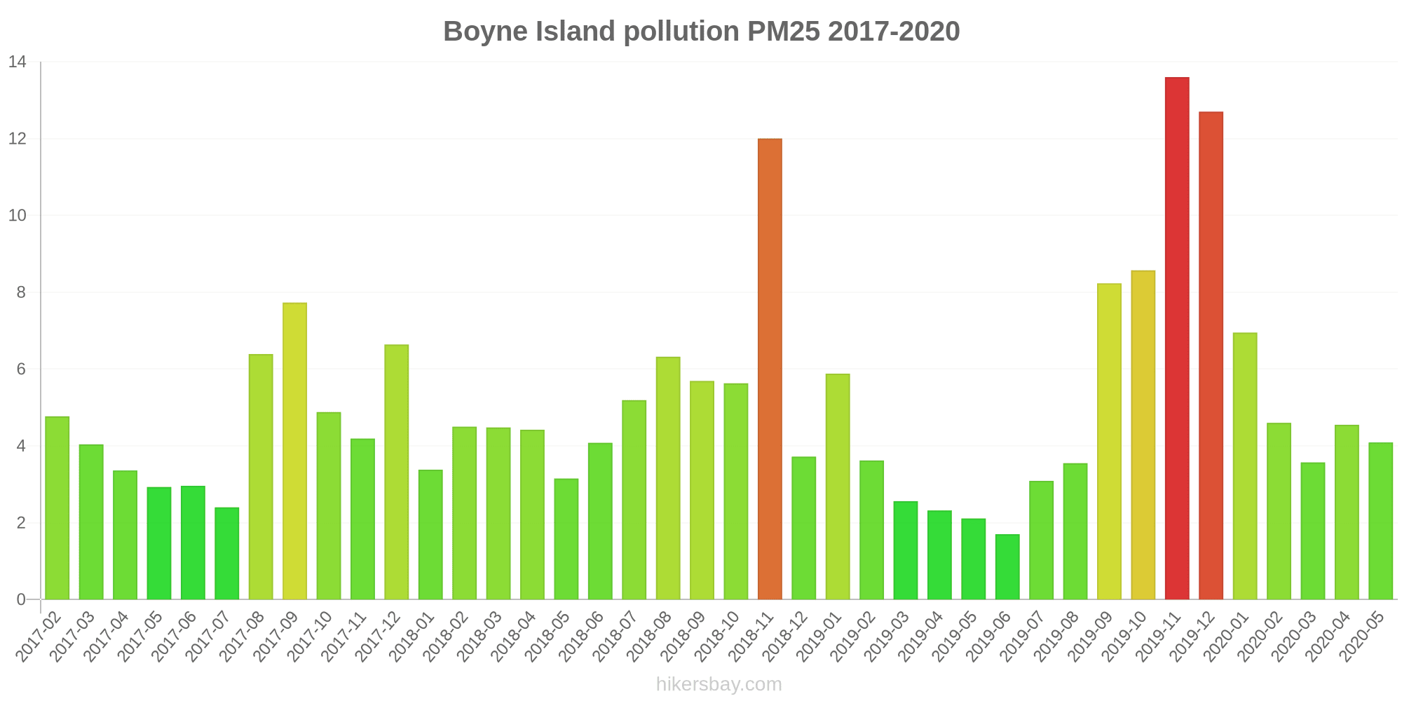
| index | 2020-05 | 2020-04 | 2020-03 | 2020-02 | 2020-01 | 2019-12 | 2019-11 | 2019-10 | 2019-09 | 2019-08 | 2019-07 | 2019-06 | 2019-05 | 2019-04 | 2019-03 | 2019-02 | 2019-01 | 2018-12 | 2018-11 | 2018-10 | 2018-09 | 2018-08 | 2018-07 | 2018-06 | 2018-05 | 2018-04 | 2018-03 | 2018-02 | 2018-01 | 2017-12 | 2017-11 | 2017-10 | 2017-09 | 2017-08 | 2017-07 | 2017-06 | 2017-05 | 2017-04 | 2017-03 | 2017-02 |
|---|---|---|---|---|---|---|---|---|---|---|---|---|---|---|---|---|---|---|---|---|---|---|---|---|---|---|---|---|---|---|---|---|---|---|---|---|---|---|---|---|
| pm10 | 13 | 13 | 10 | 12 | 16 | 31 | 31 | 21 | 19 | 5.5 | 4.5 | 4.7 | 7.8 | 11 | 8.7 | 14 | 18 | 14 | 11 | 9.8 | 15 | 15 | 10 | 10 | 11 | 15 | 13 | 12 | 11 | 9.9 | 7.8 | 8 | 11 | 7.7 | 8.8 | 8.5 | 9 | 12 | 13 | 15 |
| pm25 | 4.1 | 4.5 | 3.6 | 4.6 | 7 | 13 | 14 | 8.6 | 8.2 | 3.5 | 3.1 | 1.7 | 2.1 | 2.3 | 2.6 | 3.6 | 5.9 | 3.7 | 12 | 5.6 | 5.7 | 6.3 | 5.2 | 4.1 | 3.1 | 4.4 | 4.5 | 4.5 | 3.4 | 6.6 | 4.2 | 4.9 | 7.7 | 6.4 | 2.4 | 3 | 2.9 | 3.4 | 4 | 4.8 |
| no2:ppm | - | - | - | - | - | - | - | - | - | - | - | - | - | - | 0 | 0 | - | 0 | 0 | 0 | 0 | 0 | 0 | 0 | 0 | 0 | - | 0 | 0 | 0 | 0 | 0 | 0 | 0 | 0 | 0 | 0 | 0 | 0 | - |
| so2:ppm | - | - | - | - | - | - | - | - | - | - | - | - | 0 | 0 | 0 | 0 | 0 | 0 | 0 | 0 | 0 | 0 | 0 | 0 | 0 | 0 | - | 0 | 0 | 0 | - | 0 | 0 | - | - | - | 0 | - | 0 | - |
Clinton
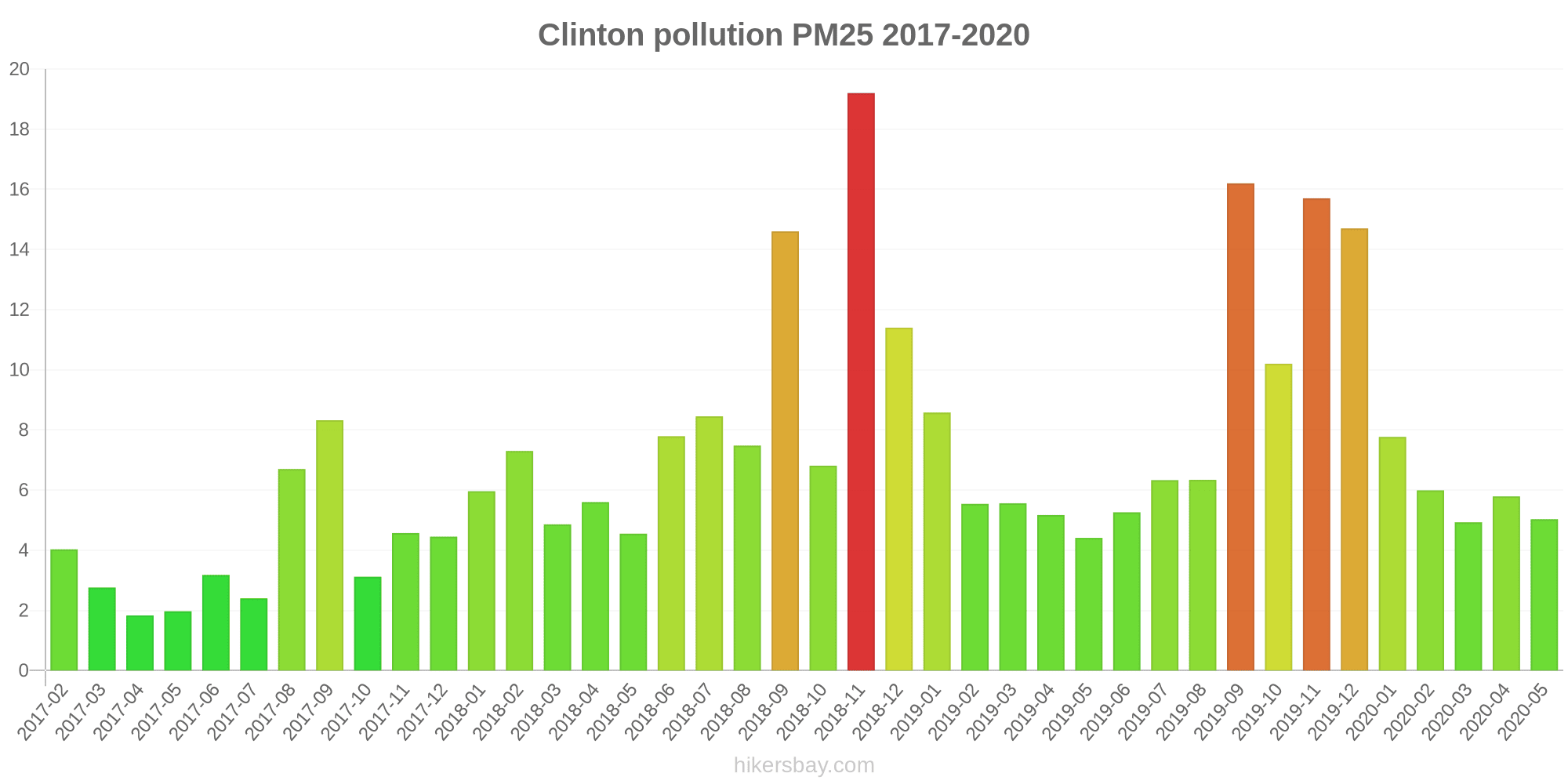
| index | 2020-05 | 2020-04 | 2020-03 | 2020-02 | 2020-01 | 2019-12 | 2019-11 | 2019-10 | 2019-09 | 2019-08 | 2019-07 | 2019-06 | 2019-05 | 2019-04 | 2019-03 | 2019-02 | 2019-01 | 2018-12 | 2018-11 | 2018-10 | 2018-09 | 2018-08 | 2018-07 | 2018-06 | 2018-05 | 2018-04 | 2018-03 | 2018-02 | 2018-01 | 2017-12 | 2017-11 | 2017-10 | 2017-09 | 2017-08 | 2017-07 | 2017-06 | 2017-05 | 2017-04 | 2017-03 | 2017-02 |
|---|---|---|---|---|---|---|---|---|---|---|---|---|---|---|---|---|---|---|---|---|---|---|---|---|---|---|---|---|---|---|---|---|---|---|---|---|---|---|---|---|
| no2:ppm | - | - | - | - | - | - | - | - | - | - | - | - | 0 | 0 | 0 | 0 | 0 | 0 | 0 | 0 | 0.01 | 0.01 | 0.01 | 0.01 | 0.01 | 0 | 0 | 0 | 0 | 0 | 0 | 0 | 0.01 | 0.01 | 0.01 | 0.01 | 0 | 0 | 0 | 0 |
| pm10 | 15 | 15 | 15 | 15 | 18 | 36 | 37 | 25 | 35 | 16 | 16 | 13 | 13 | 15 | 11 | 17 | 20 | 23 | 33 | 13 | 24 | 14 | 14 | 14 | 12 | 14 | 13 | 13 | 14 | 10 | 11 | 9.7 | 18 | 14 | 8 | 8.8 | 7.1 | 11 | 10 | 14 |
| pm25 | 5 | 5.8 | 4.9 | 6 | 7.8 | 15 | 16 | 10 | 16 | 6.3 | 6.3 | 5.3 | 4.4 | 5.2 | 5.6 | 5.5 | 8.6 | 11 | 19 | 6.8 | 15 | 7.5 | 8.4 | 7.8 | 4.5 | 5.6 | 4.9 | 7.3 | 6 | 4.5 | 4.6 | 3.1 | 8.3 | 6.7 | 2.4 | 3.2 | 2 | 1.8 | 2.8 | 4 |
| so2:ppm | - | - | - | - | - | - | - | - | - | - | - | - | - | - | 0 | - | 0 | 0 | 0 | 0 | 0 | 0 | 0 | 0 | 0 | 0 | 0 | 0 | 0 | 0 | 0 | 0 | 0 | 0 | 0.01 | 0 | 0 | 0 | 0 | - |
Fisherman's Landing
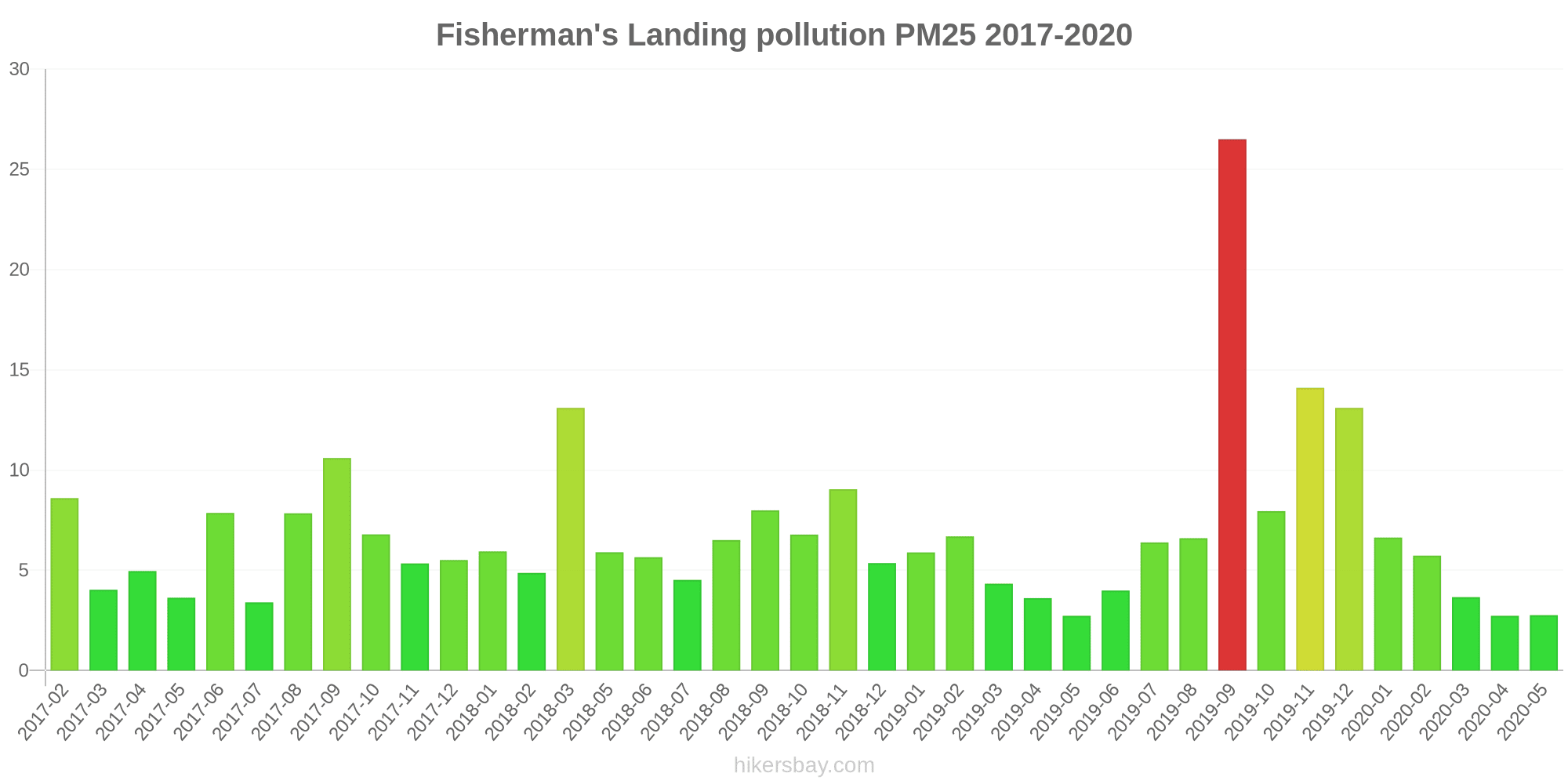
| index | 2020-05 | 2020-04 | 2020-03 | 2020-02 | 2020-01 | 2019-12 | 2019-11 | 2019-10 | 2019-09 | 2019-08 | 2019-07 | 2019-06 | 2019-05 | 2019-04 | 2019-03 | 2019-02 | 2019-01 | 2018-12 | 2018-11 | 2018-10 | 2018-09 | 2018-08 | 2018-07 | 2018-06 | 2018-05 | 2018-04 | 2018-03 | 2018-02 | 2018-01 | 2017-12 | 2017-11 | 2017-10 | 2017-09 | 2017-08 | 2017-07 | 2017-06 | 2017-05 | 2017-04 | 2017-03 | 2017-02 |
|---|---|---|---|---|---|---|---|---|---|---|---|---|---|---|---|---|---|---|---|---|---|---|---|---|---|---|---|---|---|---|---|---|---|---|---|---|---|---|---|---|
| no2:ppm | - | - | - | - | - | - | - | - | - | - | - | - | 0 | 0 | 0 | 0 | 0 | 0 | 0 | 0 | 0 | 0 | 0 | 0 | 0 | 0 | 0 | 0 | 0 | 0 | 0 | 0 | 0 | 0 | 0 | 0 | 0 | 0 | 0 | 0 |
| pm10 | 35 | 21 | 22 | 20 | 21 | 44 | 45 | 28 | 83 | 46 | 36 | 27 | 26 | 27 | 16 | 25 | 23 | 22 | 11 | 9.6 | 20 | 40 | 22 | 45 | 54 | - | 34 | 23 | 32 | 26 | 27 | 27 | 47 | 46 | 19 | 40 | 27 | 37 | 18 | 33 |
| pm25 | 2.8 | 2.7 | 3.7 | 5.7 | 6.6 | 13 | 14 | 8 | 27 | 6.6 | 6.4 | 4 | 2.7 | 3.6 | 4.3 | 6.7 | 5.9 | 5.4 | 9 | 6.8 | 8 | 6.5 | 4.5 | 5.7 | 5.9 | - | 13 | 4.9 | 5.9 | 5.5 | 5.3 | 6.8 | 11 | 7.8 | 3.4 | 7.9 | 3.6 | 5 | 4 | 8.6 |
| so2:ppm | - | - | - | - | - | - | - | - | - | - | - | - | - | - | - | - | - | - | - | - | - | - | - | - | - | - | - | - | - | - | - | - | - | - | 0 | 0 | 0 | 0 | 0 | - |
Memorial Park
| index | 2020-05 | 2020-04 | 2020-03 | 2020-01 | 2019-12 | 2019-11 | 2019-10 | 2019-09 | 2019-04 | 2019-03 | 2019-02 | 2019-01 | 2018-12 | 2018-11 | 2018-10 | 2018-09 | 2018-08 | 2018-07 | 2018-06 | 2018-05 | 2018-04 | 2018-03 | 2018-02 | 2018-01 | 2017-12 | 2017-11 | 2017-10 | 2017-09 | 2017-08 | 2017-07 | 2017-06 | 2017-05 | 2017-04 | 2017-03 | 2017-02 |
|---|---|---|---|---|---|---|---|---|---|---|---|---|---|---|---|---|---|---|---|---|---|---|---|---|---|---|---|---|---|---|---|---|---|---|---|
| no2:ppm | - | - | - | - | - | - | - | - | 0.01 | 0.01 | 0.01 | 0.01 | 0.01 | 0.01 | 0.01 | 0.01 | 0.01 | 0.01 | 0.01 | 0.01 | 0.01 | 0.01 | 0.01 | 0.01 | 0.01 | 0.01 | 0.01 | 0.01 | 0.01 | 0.01 | 0.01 | 0.01 | 0 | 0 | 0 |
| o3:ppm | 0.03 | 0.03 | 0.03 | 0.03 | 0.03 | 0.03 | 0.03 | 0.03 | 0.04 | 0.03 | 0.04 | 0.04 | 0.04 | 0.04 | 0.04 | 0.04 | 0.04 | 0.04 | 0.04 | 0.04 | 0.04 | 0.04 | 0.03 | 0.03 | 0.04 | 0.04 | 0.04 | 0.04 | 0.04 | 0.04 | 0.04 | 0.03 | 0.02 | 0.02 | 0.02 |
| so2:ppm | - | - | - | - | - | - | - | - | 0.01 | 0.01 | 0.01 | 0.01 | 0.01 | 0.01 | 0.01 | 0.01 | 0.01 | 0.01 | 0.01 | 0.01 | 0.01 | 0.01 | 0.01 | 0.01 | 0.01 | 0.01 | 0.01 | 0.01 | 0.01 | 0.01 | 0 | 0 | 0 | 0 | 0 |
South Gladstone

| index | 2020-05 | 2020-04 | 2020-03 | 2020-02 | 2020-01 | 2019-12 | 2019-11 | 2019-10 | 2019-09 | 2019-08 | 2019-07 | 2019-06 | 2019-05 | 2019-04 | 2019-03 | 2019-02 | 2019-01 | 2018-12 | 2018-11 | 2018-10 | 2018-09 | 2018-08 | 2018-07 | 2018-06 | 2018-05 | 2018-04 | 2018-03 | 2018-02 | 2018-01 | 2017-12 | 2017-11 | 2017-10 | 2017-09 | 2017-08 | 2017-07 | 2017-06 | 2017-05 | 2017-04 | 2017-03 | 2017-02 |
|---|---|---|---|---|---|---|---|---|---|---|---|---|---|---|---|---|---|---|---|---|---|---|---|---|---|---|---|---|---|---|---|---|---|---|---|---|---|---|---|---|
| no2:ppm | - | - | - | - | - | - | - | - | - | - | - | - | 0 | 0 | 0 | 0 | 0.01 | 0.01 | 0.01 | 0.01 | 0.01 | 0.01 | 0.01 | 0.01 | 0.01 | 0 | 0 | 0 | 0 | 0 | 0 | 0 | 0.01 | 0.01 | 0.01 | 0.01 | 0.01 | 0 | 0 | 0 |
| so2:ppm | - | - | - | - | - | - | - | - | - | - | - | - | 0 | 0 | 0 | 0 | 0 | 0 | 0 | 0 | 0 | 0 | 0 | 0 | 0 | 0 | 0 | 0 | 0 | 0 | 0 | 0 | 0 | 0 | 0 | 0 | 0 | 0 | 0 | 0 |
| pm10 | 8.9 | 11 | 11 | 12 | 19 | 35 | 36 | 14 | 24 | 12 | 11 | 8.4 | 9.9 | 12 | 9.7 | 17 | 18 | 21 | 27 | 10 | 28 | 11 | 8.4 | 7.1 | 9.2 | 15 | 14 | 14 | 20 | 15 | 14 | 15 | 24 | 16 | 19 | 12 | 9.5 | 14 | 13 | 16 |
| pm25 | 2 | 3.8 | 2.9 | 4.5 | 7.8 | 14 | 15 | 7 | 10 | 3.9 | 4.6 | 3.9 | 3.3 | 3.4 | 3.8 | 5.3 | 5.3 | 7.9 | 13 | 3.7 | 9 | 5 | 4.8 | 4.2 | 3.3 | 4.5 | 4.4 | 5.3 | 8.3 | 7.7 | 4.9 | 7.1 | 13 | 8 | 12 | 5.8 | 4.2 | 5.7 | 5.5 | 7 |
Targinie

| index | 2020-05 | 2020-04 | 2020-03 | 2020-02 | 2020-01 | 2019-12 | 2019-11 | 2019-10 | 2019-09 | 2019-08 | 2019-07 | 2019-06 | 2019-05 | 2019-04 | 2019-03 | 2019-02 | 2019-01 | 2018-12 | 2018-11 | 2018-10 | 2018-09 | 2018-08 | 2018-07 | 2018-06 | 2018-05 | 2018-04 | 2018-03 | 2018-02 | 2018-01 | 2017-12 | 2017-11 | 2017-10 | 2017-09 | 2017-08 | 2017-07 | 2017-06 | 2017-05 | 2017-04 | 2017-03 | 2017-02 |
|---|---|---|---|---|---|---|---|---|---|---|---|---|---|---|---|---|---|---|---|---|---|---|---|---|---|---|---|---|---|---|---|---|---|---|---|---|---|---|---|---|
| no2:ppm | - | - | - | - | - | - | - | - | - | - | - | - | 0.01 | 0 | 0 | 0 | 0 | 0 | 0 | 0 | 0 | 0 | 0 | 0 | 0 | 0 | 0 | 0.01 | 0 | 0 | 0 | 0.01 | 0.01 | 0 | 0.01 | 0.01 | 0.01 | 0.01 | 0 | 0 |
| so2:ppm | - | - | - | - | - | - | - | - | - | - | - | - | 0 | 0 | 0 | 0 | 0 | 0 | 0 | 0 | 0 | 0 | 0 | 0 | 0 | 0 | 0 | 0 | 0 | 0 | 0 | - | - | - | 0 | - | - | 0 | 0 | 0 |
| pm10 | 13 | 13 | 14 | 15 | 19 | 31 | 33 | 22 | 32 | 12 | 13 | 7.8 | 7 | 11 | 8.5 | 15 | 16 | 27 | 28 | 21 | 14 | 11 | 9 | 10 | 9.6 | 9.5 | 7.8 | 11 | 15 | - | 14 | 14 | 19 | 13 | 8.7 | 10 | 10 | 13 | 12 | 16 |
| pm25 | 3.9 | 4.5 | 4.7 | 6.5 | 7.2 | 13 | 14 | 9 | 13 | 4.5 | 8 | 2.7 | 2.7 | 3.9 | 3.9 | 4.2 | 4.6 | 15 | 13 | 14 | 4.3 | 4.2 | 3.5 | 3.6 | 3.9 | 5.2 | 4.1 | 4.9 | 5.1 | - | 6.2 | 5.4 | 7.6 | 5.2 | 2.7 | 3.3 | 3 | 3.4 | 3.5 | 4.9 |
Blackwater

| index | 2020-05 | 2020-04 | 2020-03 | 2020-02 | 2020-01 | 2019-12 | 2019-11 | 2019-10 | 2019-09 | 2019-08 | 2019-07 | 2019-06 | 2019-05 | 2019-04 |
|---|---|---|---|---|---|---|---|---|---|---|---|---|---|---|
| pm10 | 18 | 18 | 13 | 14 | 17 | 35 | 38 | 29 | 42 | 21 | 18 | 18 | 16 | 14 |
| pm25 | 4 | 4.9 | 4.2 | 4.5 | 6.9 | 12 | 12 | 9.2 | 11 | 5.2 | 4.5 | 4.1 | 3.8 | 4.2 |
Moranbah
| index | 2020-05 | 2020-04 | 2020-03 | 2020-02 | 2020-01 | 2019-12 | 2019-11 | 2019-10 | 2019-09 | 2019-08 | 2019-07 | 2019-06 | 2019-05 | 2019-04 | 2019-03 | 2019-02 | 2019-01 | 2018-12 | 2018-11 | 2018-10 | 2018-09 | 2018-08 | 2018-07 | 2018-06 | 2018-05 | 2018-04 | 2018-03 | 2018-02 | 2018-01 | 2017-12 | 2017-11 | 2017-10 | 2017-09 | 2017-08 | 2017-07 | 2017-06 | 2017-05 | 2017-04 | 2017-03 | 2017-02 |
|---|---|---|---|---|---|---|---|---|---|---|---|---|---|---|---|---|---|---|---|---|---|---|---|---|---|---|---|---|---|---|---|---|---|---|---|---|---|---|---|---|
| pm10 | 23 | 21 | 16 | 16 | 22 | 34 | 44 | 38 | 50 | 34 | 29 | 24 | 26 | 21 | 18 | 29 | 22 | 26 | 36 | 30 | 35 | 40 | 41 | 29 | 28 | 27 | 21 | 22 | 24 | 24 | 24 | 25 | 40 | 37 | 23 | 23 | 18 | 20 | 15 | 22 |
| pm25 | 5.3 | 5.5 | 4.4 | 4.8 | 7.7 | 12 | 13 | 7.8 | - | - | - | - | - | - | - | - | - | - | - | - | - | - | - | - | - | - | - | - | - | - | - | - | - | - | - | - | - | - | - | - |
West Mackay
| index | 2020-05 | 2020-04 | 2020-03 | 2020-02 | 2020-01 | 2019-12 | 2019-11 | 2019-10 | 2019-09 | 2019-08 | 2019-07 | 2019-06 | 2019-05 | 2019-04 | 2019-03 | 2019-02 | 2019-01 | 2018-12 | 2018-11 | 2018-10 | 2018-09 | 2018-08 | 2018-07 | 2018-06 | 2018-05 | 2018-04 | 2018-03 | 2018-02 | 2018-01 | 2017-12 | 2017-11 | 2017-10 | 2017-09 | 2017-08 | 2017-07 | 2017-06 | 2017-05 | 2017-04 | 2017-03 | 2017-02 |
|---|---|---|---|---|---|---|---|---|---|---|---|---|---|---|---|---|---|---|---|---|---|---|---|---|---|---|---|---|---|---|---|---|---|---|---|---|---|---|---|---|
| pm10 | 17 | 17 | 16 | 14 | 17 | 24 | 35 | 22 | 40 | 22 | 18 | 18 | 18 | 19 | 18 | 24 | 23 | 24 | 34 | 18 | 25 | 26 | 21 | 18 | 18 | 20 | 19 | 14 | 17 | 15 | 18 | 20 | 33 | 31 | 21 | 22 | 16 | 18 | 17 | 18 |
| pm25 | 5.1 | 5.3 | 5.3 | 4.9 | 6.6 | 8.8 | 13 | 7.7 | - | - | - | - | - | - | - | - | - | - | - | - | - | - | - | - | - | - | - | - | - | - | - | - | - | - | - | - | - | - | - | - |
Brisbane CBD
| index | 2020-05 | 2020-04 | 2020-03 | 2020-02 | 2020-01 | 2019-12 | 2019-11 | 2019-10 | 2019-09 | 2019-08 | 2019-07 | 2019-06 | 2019-05 | 2019-04 | 2019-03 | 2019-02 | 2019-01 | 2018-12 | 2018-11 | 2018-10 | 2018-09 | 2018-08 | 2018-07 | 2018-06 | 2018-05 | 2018-04 | 2018-03 | 2018-02 | 2018-01 | 2017-12 | 2017-11 | 2017-10 | 2017-09 | 2017-08 | 2017-07 | 2017-06 | 2017-05 | 2017-04 | 2017-03 | 2017-02 |
|---|---|---|---|---|---|---|---|---|---|---|---|---|---|---|---|---|---|---|---|---|---|---|---|---|---|---|---|---|---|---|---|---|---|---|---|---|---|---|---|---|
| pm10 | 15 | 16 | 15 | 15 | 16 | 31 | 37 | 17 | 30 | 19 | 14 | 12 | 11 | 11 | 14 | 16 | 15 | 19 | 23 | 13 | 20 | 19 | 14 | 12 | 12 | 12 | 13 | 15 | 14 | 10 | 9.7 | 13 | 20 | 20 | 12 | 11 | 12 | 11 | 12 | 13 |
| pm25 | 5.4 | 6.1 | 5.3 | 5.6 | 6.5 | - | - | - | - | - | - | - | - | - | - | - | - | - | - | - | - | - | - | - | - | - | - | - | - | - | - | - | - | - | - | - | - | - | - | - |
Cannon Hill

| index | 2020-05 | 2020-04 | 2020-03 | 2020-02 | 2020-01 | 2019-12 | 2019-11 | 2019-10 | 2019-09 | 2019-08 | 2019-07 | 2019-06 | 2019-05 | 2019-04 | 2019-03 | 2019-02 | 2019-01 | 2018-12 | 2018-11 | 2018-10 | 2018-09 | 2018-08 | 2018-07 | 2018-06 | 2018-05 | 2018-04 | 2018-03 | 2018-02 | 2018-01 | 2017-12 | 2017-11 | 2017-10 | 2017-09 | 2017-08 | 2017-07 | 2017-06 | 2017-05 | 2017-04 | 2017-03 | 2017-02 |
|---|---|---|---|---|---|---|---|---|---|---|---|---|---|---|---|---|---|---|---|---|---|---|---|---|---|---|---|---|---|---|---|---|---|---|---|---|---|---|---|---|
| pm10 | 14 | 16 | 13 | 13 | 21 | 64 | 54 | 25 | 32 | 20 | 16 | 14 | 11 | 11 | 15 | 16 | 16 | 20 | 27 | 13 | 22 | 22 | 18 | 15 | 16 | 15 | 14 | 8.6 | 16 | 13 | 12 | 16 | 24 | 21 | 16 | 13 | 14 | 16 | 13 | 15 |
| pm25 | 6 | 7.5 | 4.3 | 5 | 8.3 | 24 | 20 | 7.4 | 10 | 8.6 | 8.6 | 7.8 | 5.5 | 4.2 | 6.2 | 5.3 | 6.1 | 7.8 | 8.4 | 5.8 | 7.7 | 12 | 10 | 8.4 | 7.3 | 6 | 5.5 | 4.1 | 6.9 | 6.3 | 5.1 | 7.4 | 12 | 13 | 11 | 7.1 | 8.3 | 6.7 | 6.3 | 6.3 |
| o3:ppm | 0.02 | 0.02 | 0.02 | 0.01 | 0.02 | 0.03 | 0.02 | 0.02 | 0.02 | 0.02 | 0.01 | 0.01 | 0.01 | 0.01 | 0.02 | 0.01 | 0.01 | 0.02 | 0.02 | 0.02 | 0.02 | 0.02 | 0.02 | 0.01 | 0.01 | 0.01 | 0.01 | 0.02 | 0.01 | 0.02 | 0.02 | 0.02 | 0.02 | 0.02 | 0.01 | 0.01 | 0.01 | 0.02 | - | - |
Deception Bay
| index | 2020-05 | 2020-04 | 2020-03 | 2020-02 | 2020-01 | 2019-12 | 2019-11 | 2019-10 | 2019-09 | 2019-08 | 2019-07 | 2019-06 | 2019-05 | 2019-04 | 2019-03 | 2019-02 | 2019-01 | 2018-12 | 2018-11 | 2018-10 | 2018-09 | 2018-08 | 2018-07 | 2018-06 | 2018-05 | 2018-04 | 2018-03 | 2018-02 | 2018-01 | 2017-12 | 2017-11 | 2017-10 | 2017-09 | 2017-08 | 2017-07 | 2017-06 | 2017-05 | 2017-04 | 2017-03 | 2017-02 |
|---|---|---|---|---|---|---|---|---|---|---|---|---|---|---|---|---|---|---|---|---|---|---|---|---|---|---|---|---|---|---|---|---|---|---|---|---|---|---|---|---|
| no2:ppm | - | - | - | - | - | - | - | - | - | - | - | - | 0.01 | 0 | 0 | 0 | 0 | 0 | 0 | 0 | 0 | 0.01 | 0.01 | 0.01 | 0.01 | 0 | 0 | 0 | 0 | 0 | 0 | 0 | 0 | 0.01 | 0.01 | 0.01 | 0.01 | 0 | 0 | 0 |
| o3:ppm | 0.02 | 0.02 | 0.02 | 0.02 | 0.02 | 0.03 | 0.03 | 0.02 | 0.02 | 0.02 | 0.02 | 0.02 | 0.02 | 0.02 | 0.02 | 0.02 | 0.01 | 0.02 | 0.02 | 0.03 | 0.02 | 0.02 | 0.02 | 0.02 | 0.02 | 0.02 | 0.02 | 0.02 | 0.02 | 0.02 | 0.02 | 0.03 | 0.03 | 0.02 | 0.02 | 0.02 | 0.02 | 0.02 | 0.02 | 0.02 |
Flinders View
| index | 2020-05 | 2020-04 | 2020-03 | 2020-02 | 2020-01 | 2019-12 | 2019-11 | 2019-10 | 2019-09 | 2019-08 | 2019-07 | 2019-06 | 2019-05 | 2019-04 | 2019-03 | 2019-02 | 2019-01 | 2018-12 | 2018-11 | 2018-10 | 2018-09 | 2018-08 | 2018-07 | 2018-06 | 2018-05 | 2018-04 | 2018-03 | 2018-02 | 2018-01 | 2017-12 | 2017-11 | 2017-10 | 2017-09 | 2017-08 | 2017-07 | 2017-06 | 2017-05 | 2017-04 | 2017-03 | 2017-02 |
|---|---|---|---|---|---|---|---|---|---|---|---|---|---|---|---|---|---|---|---|---|---|---|---|---|---|---|---|---|---|---|---|---|---|---|---|---|---|---|---|---|
| no2:ppm | - | - | - | - | - | - | - | - | - | - | - | - | 0.01 | 0.01 | 0.01 | 0 | 0 | 0 | 0 | 0 | 0.01 | 0.01 | 0.01 | 0.01 | 0.01 | 0.01 | 0 | 0 | 0 | 0 | 0 | 0 | 0.01 | 0.01 | 0.01 | 0.01 | 0.01 | 0.01 | 0.01 | 0.01 |
| o3:ppm | 0.02 | 0.02 | 0.02 | 0.02 | 0.02 | 0.03 | 0.03 | 0.02 | 0.02 | 0.02 | 0.02 | 0.01 | 0.01 | 0.01 | 0.02 | 0.02 | 0.02 | 0.02 | 0.02 | 0.02 | 0.02 | 0.02 | 0.01 | 0.01 | 0.01 | 0.01 | 0.01 | 0.02 | 0.02 | 0.02 | 0.02 | 0.02 | 0.03 | 0.02 | 0.01 | 0.01 | 0.01 | 0.02 | 0.02 | 0.02 |
| pm10 | 18 | 19 | 16 | 15 | 18 | 41 | 50 | 24 | 35 | 22 | 17 | 14 | 14 | 14 | 18 | 21 | 21 | 26 | 30 | 14 | 26 | 23 | 17 | 15 | 16 | 16 | 16 | 17 | 19 | 16 | 15 | 16 | 26 | 22 | 13 | 13 | 14 | 13 | 13 | 16 |
| so2:ppm | - | - | - | - | - | - | - | - | - | - | - | - | - | - | - | - | - | - | - | - | 0 | 0 | 0 | 0 | 0 | 0 | 0 | - | 0 | 0 | 0 | 0 | - | - | - | - | 0 | 0 | 0 | - |
Lytton
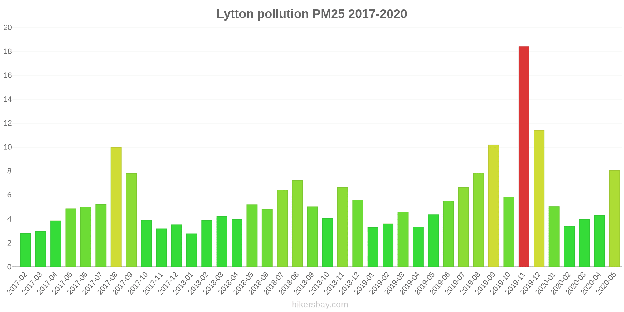
| index | 2020-05 | 2020-04 | 2020-03 | 2020-02 | 2020-01 | 2019-12 | 2019-11 | 2019-10 | 2019-09 | 2019-08 | 2019-07 | 2019-06 | 2019-05 | 2019-04 | 2019-03 | 2019-02 | 2019-01 | 2018-12 | 2018-11 | 2018-10 | 2018-09 | 2018-08 | 2018-07 | 2018-06 | 2018-05 | 2018-04 | 2018-03 | 2018-02 | 2018-01 | 2017-12 | 2017-11 | 2017-10 | 2017-09 | 2017-08 | 2017-07 | 2017-06 | 2017-05 | 2017-04 | 2017-03 | 2017-02 |
|---|---|---|---|---|---|---|---|---|---|---|---|---|---|---|---|---|---|---|---|---|---|---|---|---|---|---|---|---|---|---|---|---|---|---|---|---|---|---|---|---|
| pm10 | 22 | 16 | 14 | 14 | 15 | 36 | 44 | 18 | 30 | 12 | 9.3 | 12 | 15 | 14 | 15 | 17 | 16 | 20 | 29 | 14 | 17 | 13 | 11 | 13 | 19 | 11 | 15 | 12 | 14 | 13 | 12 | 16 | 27 | 31 | 18 | 18 | 17 | 14 | 13 | 14 |
| pm25 | 8.1 | 4.3 | 4 | 3.4 | 5.1 | 11 | 18 | 5.8 | 10 | 7.8 | 6.7 | 5.5 | 4.4 | 3.4 | 4.6 | 3.6 | 3.3 | 5.6 | 6.7 | 4.1 | 5 | 7.2 | 6.4 | 4.8 | 5.2 | 4 | 4.2 | 3.9 | 2.8 | 3.5 | 3.2 | 3.9 | 7.8 | 10 | 5.2 | 5 | 4.9 | 3.9 | 3 | 2.8 |
| so2:ppm | - | - | - | - | - | - | - | - | - | - | - | - | - | - | 0.01 | 0.01 | - | - | - | 0 | 0 | 0 | 0 | 0 | 0 | 0 | 0.01 | 0.01 | 0 | 0 | 0.01 | - | 0 | 0 | - | - | - | - | - | - |
Mountain Creek
| index | 2020-05 | 2020-04 | 2020-03 | 2020-02 | 2020-01 | 2019-12 | 2019-11 | 2019-10 | 2019-09 | 2019-08 | 2019-07 | 2019-06 | 2019-05 | 2019-04 | 2019-03 | 2019-02 | 2019-01 | 2018-12 | 2018-11 | 2018-10 | 2018-09 | 2018-08 | 2018-07 | 2018-06 | 2018-05 | 2018-04 | 2018-03 | 2018-02 | 2018-01 | 2017-12 | 2017-11 | 2017-10 | 2017-09 | 2017-08 | 2017-07 | 2017-06 | 2017-05 | 2017-04 | 2017-03 | 2017-02 |
|---|---|---|---|---|---|---|---|---|---|---|---|---|---|---|---|---|---|---|---|---|---|---|---|---|---|---|---|---|---|---|---|---|---|---|---|---|---|---|---|---|
| no2:ppm | - | - | - | - | - | - | - | - | - | - | - | - | 0 | 0 | 0 | 0 | 0 | 0 | 0 | 0 | 0 | 0.01 | 0.01 | 0.01 | 0 | 0 | 0 | 0 | 0 | 0 | 0 | 0 | 0 | 0.01 | 0.01 | 0.01 | 0.01 | 0 | 0 | 0 |
| o3:ppm | 0.02 | 0.02 | 0.02 | 0.02 | 0.02 | 0.02 | 0.02 | 0.02 | 0.03 | 0.02 | 0.02 | 0.02 | 0.02 | 0.02 | 0.02 | 0.02 | 0.01 | 0.02 | 0.02 | 0.02 | 0.02 | 0.02 | 0.02 | 0.02 | 0.02 | 0.02 | 0.02 | 0.02 | 0.02 | 0.02 | 0.02 | 0.03 | 0.03 | 0.03 | 0.02 | 0.02 | 0.02 | 0.02 | 0.02 | 0.02 |
| pm10 | 15 | 16 | 15 | 17 | 19 | 37 | 36 | 21 | 37 | 19 | 16 | 14 | 14 | 18 | 19 | 25 | 21 | 26 | 27 | 17 | 21 | 19 | 16 | 14 | 15 | 19 | 21 | 20 | 21 | 16 | 17 | 20 | 25 | 20 | 11 | 12 | 14 | 15 | 18 | 19 |
Mutdapilly
| index | 2020-05 | 2020-04 | 2020-03 | 2020-02 | 2020-01 | 2019-12 | 2019-11 | 2019-10 | 2019-09 | 2019-08 | 2019-07 | 2019-06 | 2019-05 | 2019-04 | 2019-03 | 2019-02 | 2019-01 | 2018-12 | 2018-11 | 2018-10 | 2018-09 | 2018-08 | 2018-07 | 2018-06 | 2018-05 | 2018-04 | 2018-03 | 2018-02 | 2018-01 | 2017-12 | 2017-11 | 2017-10 | 2017-09 | 2017-08 | 2017-07 | 2017-06 | 2017-05 | 2017-04 | 2017-03 | 2017-02 |
|---|---|---|---|---|---|---|---|---|---|---|---|---|---|---|---|---|---|---|---|---|---|---|---|---|---|---|---|---|---|---|---|---|---|---|---|---|---|---|---|---|
| no2:ppm | - | - | - | - | - | - | - | - | - | - | - | - | 0 | 0 | 0 | 0 | 0 | 0 | 0 | 0 | 0 | 0 | 0.01 | 0 | 0 | 0 | 0 | 0 | 0 | 0 | 0 | 0 | 0 | 0.01 | 0 | 0 | 0 | 0 | 0 | 0 |
| o3:ppm | 0.02 | 0.02 | 0.02 | 0.02 | 0.02 | 0.03 | 0.03 | 0.03 | 0.03 | 0.02 | 0.03 | 0.02 | 0.02 | 0.02 | 0.02 | 0.02 | 0.02 | 0.02 | 0.03 | 0.03 | 0.03 | 0.03 | 0.02 | 0.02 | 0.02 | 0.02 | 0.02 | 0.02 | 0.02 | 0.02 | 0.02 | 0.03 | 0.03 | 0.03 | 0.02 | 0.02 | 0.02 | 0.02 | 0.02 | 0.02 |
North Maclean
| index | 2020-05 | 2020-04 | 2020-03 | 2020-02 | 2020-01 | 2019-12 | 2019-11 | 2019-10 | 2019-09 | 2019-08 | 2019-07 | 2019-06 | 2019-05 | 2019-04 | 2019-03 | 2019-02 | 2019-01 | 2018-12 | 2018-11 | 2018-10 | 2018-09 | 2018-08 | 2018-07 | 2018-06 | 2018-05 | 2018-04 | 2018-03 | 2018-02 | 2018-01 | 2017-12 | 2017-11 | 2017-10 | 2017-09 | 2017-08 | 2017-07 | 2017-06 | 2017-05 | 2017-04 | 2017-03 | 2017-02 |
|---|---|---|---|---|---|---|---|---|---|---|---|---|---|---|---|---|---|---|---|---|---|---|---|---|---|---|---|---|---|---|---|---|---|---|---|---|---|---|---|---|
| no2:ppm | - | - | - | - | - | - | - | - | - | - | - | - | 0 | 0 | 0 | 0 | 0 | 0 | 0 | 0 | 0 | 0.01 | 0.01 | 0.01 | 0 | 0 | 0 | 0 | 0 | 0 | 0 | 0 | 0.01 | 0.01 | 0 | 0 | 0 | 0 | 0 | 0 |
| o3:ppm | 0.02 | 0.02 | 0.02 | 0.02 | 0.02 | 0.02 | 0.03 | 0.02 | 0.02 | 0.02 | 0.01 | 0.02 | 0.01 | 0.02 | 0.02 | 0.02 | 0.01 | 0.01 | 0.02 | 0.02 | 0.02 | 0.02 | 0.02 | 0.01 | 0.02 | 0.01 | 0.01 | 0.02 | 0.02 | 0.02 | 0.02 | 0.02 | 0.02 | 0.02 | 0.01 | 0.02 | 0.02 | 0.02 | 0.02 | 0.02 |
Rocklea

| index | 2020-05 | 2020-04 | 2020-03 | 2020-02 | 2020-01 | 2019-12 | 2019-11 | 2019-10 | 2019-09 | 2019-08 | 2019-07 | 2019-06 | 2019-05 | 2019-04 | 2019-03 | 2019-02 | 2019-01 | 2018-12 | 2018-11 | 2018-10 | 2018-09 | 2018-08 | 2018-07 | 2018-06 | 2018-05 | 2018-04 | 2018-03 | 2018-02 | 2018-01 | 2017-12 | 2017-11 | 2017-10 | 2017-09 | 2017-08 | 2017-07 | 2017-06 | 2017-05 | 2017-04 | 2017-03 | 2017-02 |
|---|---|---|---|---|---|---|---|---|---|---|---|---|---|---|---|---|---|---|---|---|---|---|---|---|---|---|---|---|---|---|---|---|---|---|---|---|---|---|---|---|
| no2:ppm | - | - | - | - | - | - | - | - | - | - | - | - | 0.01 | 0.01 | 0.01 | 0 | 0 | 0 | 0 | 0.01 | 0.01 | 0.01 | 0.01 | 0.01 | 0.01 | 0.01 | 0 | 0.01 | 0 | 0.01 | 0.01 | 0.01 | 0.01 | 0.01 | 0.01 | 0.01 | 0.01 | 0.01 | 0.01 | 0 |
| o3:ppm | 0.02 | 0.02 | 0.02 | 0.02 | 0.02 | 0.03 | 0.03 | 0.02 | 0.02 | 0.02 | 0.02 | 0.01 | 0.01 | 0.01 | 0.02 | 0.02 | 0.01 | 0.02 | 0.02 | 0.02 | 0.02 | 0.02 | 0.01 | 0.01 | 0.01 | 0.01 | 0.01 | 0.02 | 0.02 | 0.02 | 0.02 | 0.02 | 0.02 | 0.02 | 0.01 | 0.02 | 0.01 | 0.02 | 0.02 | 0.02 |
| pm10 | 11 | 12 | 12 | 13 | 16 | 36 | 44 | 19 | 33 | 19 | 15 | 12 | 10 | 9.6 | 13 | 14 | 14 | 18 | 23 | 12 | 19 | 19 | 15 | 12 | 12 | 10 | 12 | 13 | 15 | 13 | 11 | 15 | 23 | 20 | 14 | 11 | 12 | 11 | 12 | 13 |
| pm25 | 4.6 | 6.1 | 4.4 | 4.6 | 7.3 | 16 | 20 | 7.5 | 12 | 8.5 | 8.9 | 6.7 | 4.5 | 3.2 | 5.7 | 4.6 | 5.7 | 7 | 7.6 | 5.3 | 6.4 | 9.4 | 8.9 | 6.8 | 5.7 | 3.7 | 4.6 | 5.5 | 5.9 | 5.5 | 4.4 | 6.5 | 11 | 13 | 9.4 | 6.2 | 7.2 | 5.2 | 5.5 | 5.4 |
South Brisbane
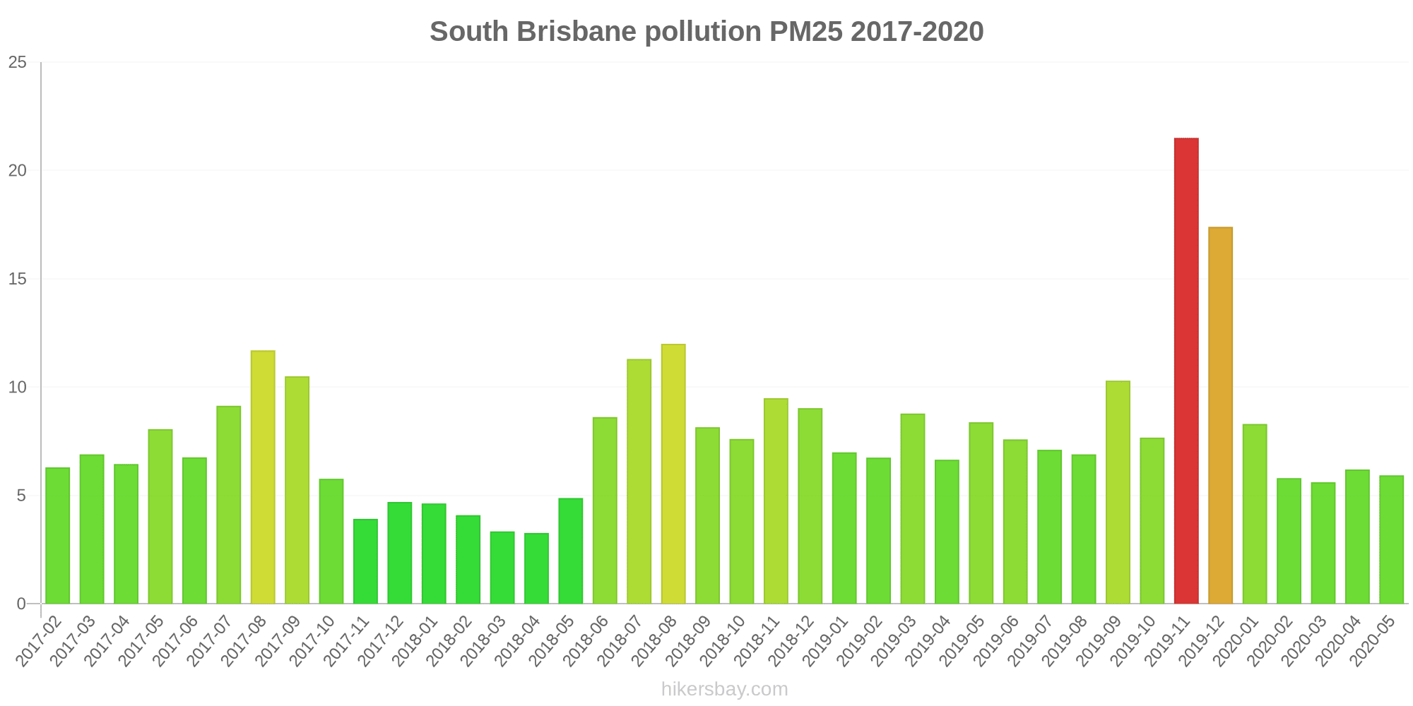
| index | 2020-05 | 2020-04 | 2020-03 | 2020-02 | 2020-01 | 2019-12 | 2019-11 | 2019-10 | 2019-09 | 2019-08 | 2019-07 | 2019-06 | 2019-05 | 2019-04 | 2019-03 | 2019-02 | 2019-01 | 2018-12 | 2018-11 | 2018-10 | 2018-09 | 2018-08 | 2018-07 | 2018-06 | 2018-05 | 2018-04 | 2018-03 | 2018-02 | 2018-01 | 2017-12 | 2017-11 | 2017-10 | 2017-09 | 2017-08 | 2017-07 | 2017-06 | 2017-05 | 2017-04 | 2017-03 | 2017-02 |
|---|---|---|---|---|---|---|---|---|---|---|---|---|---|---|---|---|---|---|---|---|---|---|---|---|---|---|---|---|---|---|---|---|---|---|---|---|---|---|---|---|
| co:ppm | - | - | - | - | - | - | - | - | - | - | - | - | - | 0.05 | - | - | - | - | 0.12 | 0.19 | 0.36 | 0.8 | 0.74 | 0.66 | 0.75 | 0.63 | 0.57 | 0.55 | 0.49 | 0.5 | 0.46 | 0.47 | 0.77 | 1.4 | 0.6 | 0.09 | 0.2 | 0.28 | 0.34 | 0.35 |
| no2:ppm | - | - | - | - | - | - | - | - | - | - | - | - | 0.02 | 0.01 | 0.01 | 0.01 | 0.01 | 0.01 | 0.01 | 0.01 | 0.02 | 0.02 | 0.02 | 0.02 | 0.02 | 0.01 | 0.01 | 0.01 | 0.01 | 0.01 | 0.01 | 0.01 | 0.02 | 0.02 | 0.02 | 0.02 | 0.02 | 0.02 | 0.01 | 0.01 |
| pm10 | 19 | 19 | 19 | 17 | 19 | 37 | 41 | 20 | 30 | 19 | 16 | 15 | 19 | 17 | 20 | 21 | 18 | 22 | 27 | 15 | 23 | 23 | 19 | 16 | 13 | 12 | 12 | 12 | 13 | 12 | 11 | 14 | 22 | 20 | 15 | 13 | 15 | 13 | 14 | 14 |
| pm25 | 5.9 | 6.2 | 5.6 | 5.8 | 8.3 | 17 | 22 | 7.7 | 10 | 6.9 | 7.1 | 7.6 | 8.4 | 6.7 | 8.8 | 6.8 | 7 | 9 | 9.5 | 7.6 | 8.2 | 12 | 11 | 8.6 | 4.9 | 3.3 | 3.3 | 4.1 | 4.6 | 4.7 | 3.9 | 5.8 | 11 | 12 | 9.1 | 6.8 | 8.1 | 6.5 | 6.9 | 6.3 |
Southport
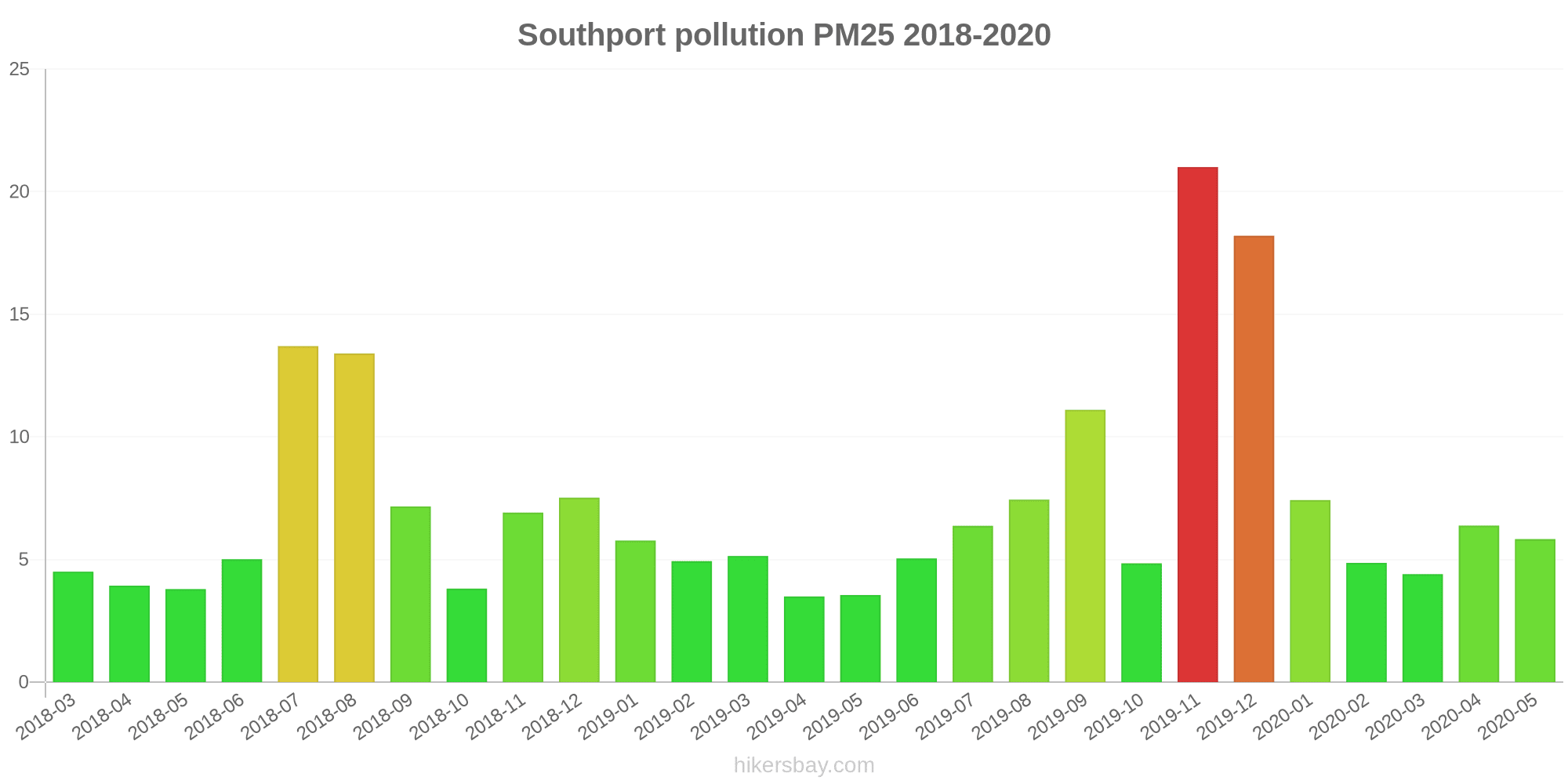
| index | 2020-05 | 2020-04 | 2020-03 | 2020-02 | 2020-01 | 2019-12 | 2019-11 | 2019-10 | 2019-09 | 2019-08 | 2019-07 | 2019-06 | 2019-05 | 2019-04 | 2019-03 | 2019-02 | 2019-01 | 2018-12 | 2018-11 | 2018-10 | 2018-09 | 2018-08 | 2018-07 | 2018-06 | 2018-05 | 2018-04 | 2018-03 |
|---|---|---|---|---|---|---|---|---|---|---|---|---|---|---|---|---|---|---|---|---|---|---|---|---|---|---|---|
| no2:ppm | - | - | - | - | - | - | - | - | - | - | - | - | 0 | 0 | 0 | 0 | 0 | 0 | 0 | 0 | 0 | 0.01 | 0.01 | 0.01 | 0.01 | 0 | 0 |
| o3:ppm | 0.02 | 0.02 | 0.02 | 0.02 | 0.02 | 0.03 | 0.03 | 0.02 | 0.03 | 0.02 | 0.02 | 0.02 | 0.02 | 0.02 | 0.02 | 0.02 | 0.01 | 0.02 | 0.02 | 0.03 | 0.02 | 0.02 | 0.02 | 0.02 | 0.02 | 0.02 | 0.01 |
| pm10 | 13 | 13 | 13 | 14 | 18 | 40 | 42 | 17 | 26 | 18 | 13 | 9.7 | 7.1 | 11 | 14 | 16 | 17 | 20 | 22 | 11 | 20 | 24 | 20 | 10 | 11 | 12 | 15 |
| pm25 | 5.8 | 6.4 | 4.4 | 4.9 | 7.4 | 18 | 21 | 4.8 | 11 | 7.4 | 6.4 | 5 | 3.5 | 3.5 | 5.1 | 4.9 | 5.8 | 7.5 | 6.9 | 3.8 | 7.2 | 13 | 14 | 5 | 3.8 | 3.9 | 4.5 |
| co:ppm | - | - | - | - | - | - | - | - | - | - | - | - | - | - | - | - | - | - | - | - | 0.42 | 0.43 | 0.36 | 0.23 | 0.11 | - | - |
Springwood
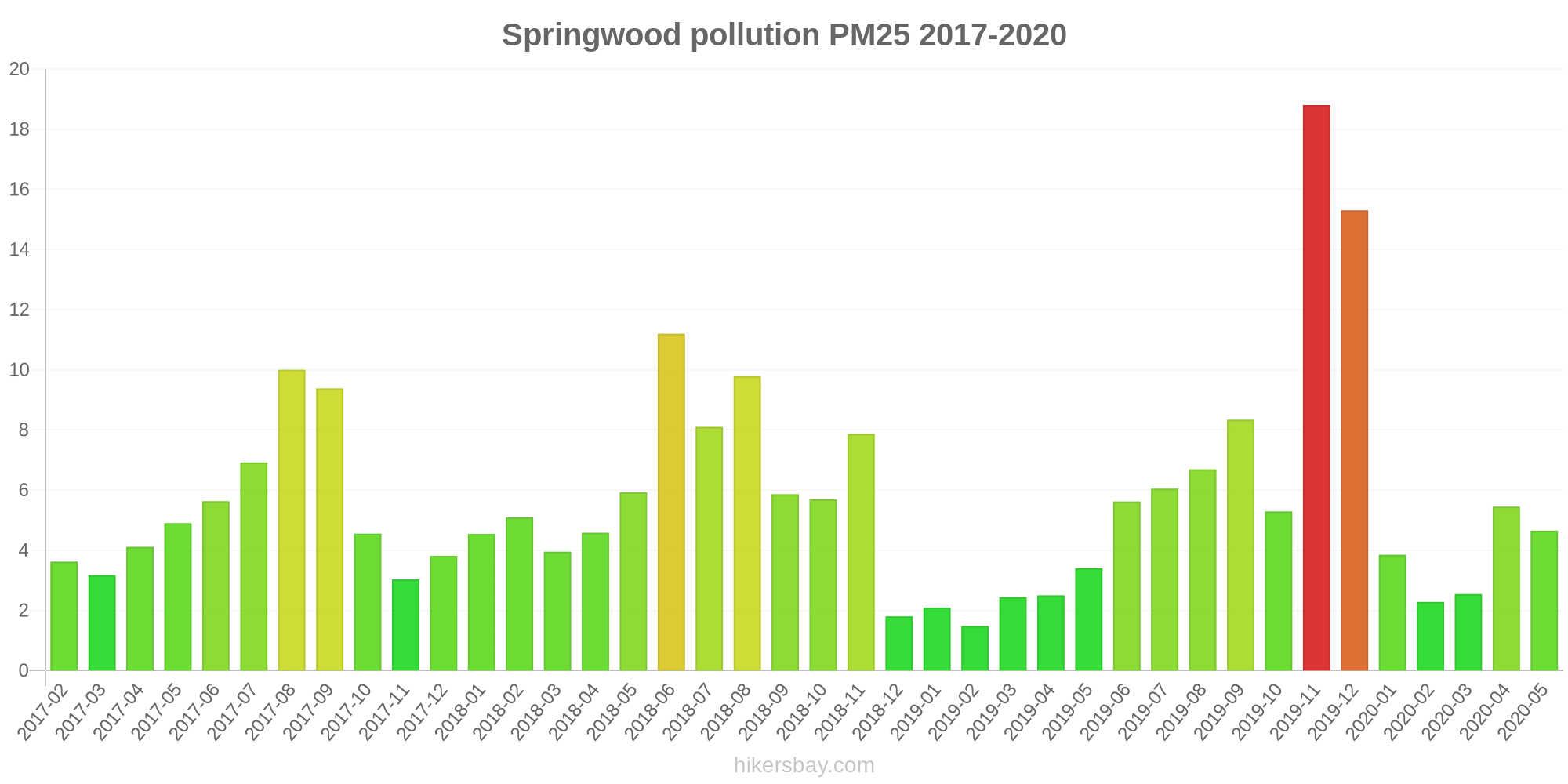
| index | 2020-05 | 2020-04 | 2020-03 | 2020-02 | 2020-01 | 2019-12 | 2019-11 | 2019-10 | 2019-09 | 2019-08 | 2019-07 | 2019-06 | 2019-05 | 2019-04 | 2019-03 | 2019-02 | 2019-01 | 2018-12 | 2018-11 | 2018-10 | 2018-09 | 2018-08 | 2018-07 | 2018-06 | 2018-05 | 2018-04 | 2018-03 | 2018-02 | 2018-01 | 2017-12 | 2017-11 | 2017-10 | 2017-09 | 2017-08 | 2017-07 | 2017-06 | 2017-05 | 2017-04 | 2017-03 | 2017-02 |
|---|---|---|---|---|---|---|---|---|---|---|---|---|---|---|---|---|---|---|---|---|---|---|---|---|---|---|---|---|---|---|---|---|---|---|---|---|---|---|---|---|
| no2:ppm | - | - | - | - | - | - | - | - | - | - | - | - | 0.01 | 0.01 | 0 | 0 | 0 | 0.01 | 0.01 | 0.01 | 0.01 | 0.01 | 0.01 | 0.01 | 0.01 | 0.01 | 0 | 0.01 | 0 | 0 | 0 | 0 | 0.01 | 0.01 | 0.01 | 0.01 | 0.01 | 0.01 | 0 | 0 |
| o3:ppm | 0.02 | 0.02 | 0.02 | 0.01 | 0.01 | 0.02 | 0.01 | 0.01 | 0.02 | 0.02 | 0.01 | 0.01 | 0.01 | 0.01 | 0.02 | 0.01 | 0.01 | 0.01 | 0.02 | - | - | 0.02 | 0.02 | 0.02 | 0.03 | 0.02 | 0.01 | 0.01 | 0.01 | 0.01 | 0.02 | 0.02 | 0.02 | 0.02 | 0.01 | 0.01 | 0.01 | 0.02 | 0.02 | 0.02 |
| so2:ppm | - | - | - | - | - | - | - | - | - | - | - | - | 0 | 0 | 0 | 0 | 0 | 0 | 0 | - | - | 0 | 0 | 0 | 0 | 0 | 0 | 0 | 0 | 0 | 0 | 0 | 0 | 0 | 0 | 0 | 0 | 0 | 0 | 0 |
| pm10 | 12 | 13 | 9.9 | 10 | 12 | 35 | 38 | 16 | 25 | 17 | 12 | 10 | 8.2 | 9.2 | 9.8 | 10 | 10 | 9.6 | 20 | 11 | 16 | 17 | 13 | 15 | 11 | 12 | 12 | 12 | 12 | 9.5 | 8.8 | 12 | 20 | 17 | 10 | 9.8 | 9.1 | 9.2 | 9.5 | 11 |
| pm25 | 4.7 | 5.5 | 2.5 | 2.3 | 3.9 | 15 | 19 | 5.3 | 8.3 | 6.7 | 6 | 5.6 | 3.4 | 2.5 | 2.4 | 1.5 | 2.1 | 1.8 | 7.9 | 5.7 | 5.9 | 9.8 | 8.1 | 11 | 5.9 | 4.6 | 4 | 5.1 | 4.5 | 3.8 | 3 | 4.5 | 9.4 | 10 | 6.9 | 5.6 | 4.9 | 4.1 | 3.2 | 3.6 |
Woolloongabba
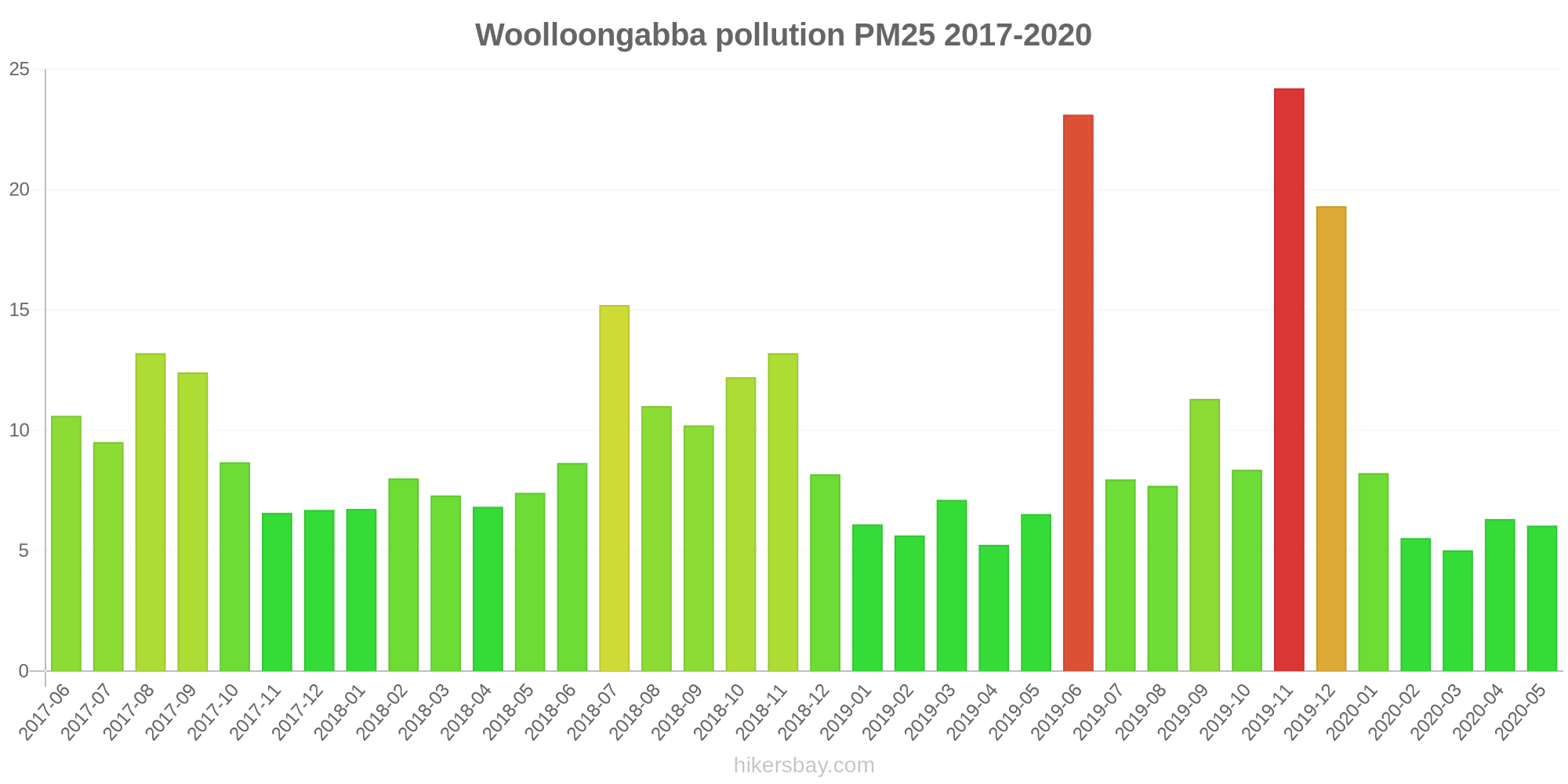
| index | 2020-05 | 2020-04 | 2020-03 | 2020-02 | 2020-01 | 2019-12 | 2019-11 | 2019-10 | 2019-09 | 2019-08 | 2019-07 | 2019-06 | 2019-05 | 2019-04 | 2019-03 | 2019-02 | 2019-01 | 2018-12 | 2018-11 | 2018-10 | 2018-09 | 2018-08 | 2018-07 | 2018-06 | 2018-05 | 2018-04 | 2018-03 | 2018-02 | 2018-01 | 2017-12 | 2017-11 | 2017-10 | 2017-09 | 2017-08 | 2017-07 | 2017-06 |
|---|---|---|---|---|---|---|---|---|---|---|---|---|---|---|---|---|---|---|---|---|---|---|---|---|---|---|---|---|---|---|---|---|---|---|---|---|
| no2:ppm | - | - | - | - | - | - | - | - | - | - | - | - | 0.02 | 0.01 | 0.01 | 0.01 | 0.01 | 0.01 | 0.01 | 0.02 | 0.02 | 0.02 | 0.02 | 0.02 | 0.02 | 0.02 | 0.01 | 0.01 | 0.01 | 0.01 | 0.02 | 0.02 | 0.02 | 0.02 | 0.02 | 0.02 |
| co:ppm | - | - | - | - | - | - | - | - | - | - | - | - | 0.29 | 0.28 | 0.3 | 0.42 | 0.18 | 0.16 | 0.09 | 0.19 | 0.26 | 0.26 | 0.24 | 0.16 | 0.23 | 0.14 | 0.17 | 0.18 | 0.07 | 0.1 | 0.13 | 0.13 | 0.09 | 0.18 | 0.18 | 0.17 |
| pm10 | 17 | 17 | 14 | 15 | 19 | 41 | 46 | 22 | 32 | 21 | 18 | 28 | 12 | 12 | 15 | 13 | 16 | 21 | 30 | 20 | 25 | 22 | 21 | 15 | 16 | 15 | 16 | 17 | 16 | 14 | 14 | 17 | 24 | 22 | 15 | 20 |
| pm25 | 6 | 6.3 | 5 | 5.5 | 8.2 | 19 | 24 | 8.4 | 11 | 7.7 | 8 | 23 | 6.5 | 5.2 | 7.1 | 5.6 | 6.1 | 8.2 | 13 | 12 | 10 | 11 | 15 | 8.6 | 7.4 | 6.8 | 7.3 | 8 | 6.7 | 6.7 | 6.6 | 8.7 | 12 | 13 | 9.5 | 11 |
Wynnum West
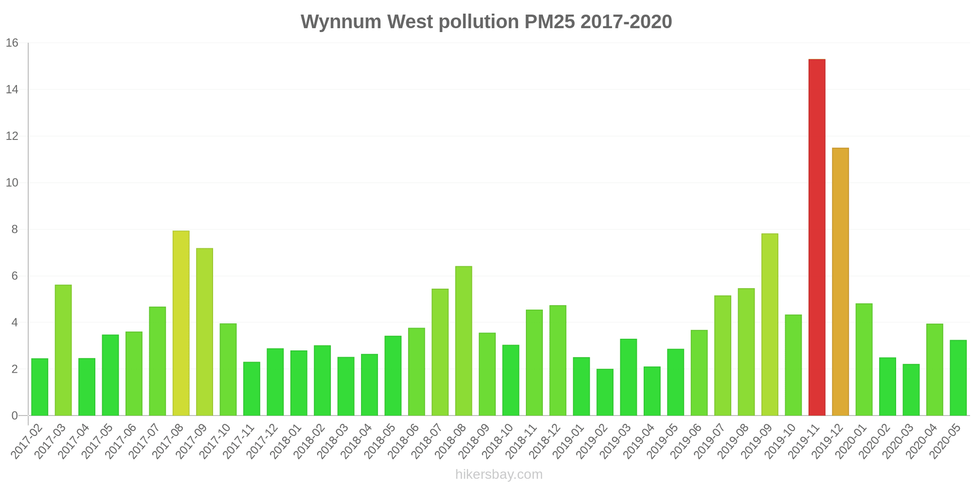
| index | 2020-05 | 2020-04 | 2020-03 | 2020-02 | 2020-01 | 2019-12 | 2019-11 | 2019-10 | 2019-09 | 2019-08 | 2019-07 | 2019-06 | 2019-05 | 2019-04 | 2019-03 | 2019-02 | 2019-01 | 2018-12 | 2018-11 | 2018-10 | 2018-09 | 2018-08 | 2018-07 | 2018-06 | 2018-05 | 2018-04 | 2018-03 | 2018-02 | 2018-01 | 2017-12 | 2017-11 | 2017-10 | 2017-09 | 2017-08 | 2017-07 | 2017-06 | 2017-05 | 2017-04 | 2017-03 | 2017-02 |
|---|---|---|---|---|---|---|---|---|---|---|---|---|---|---|---|---|---|---|---|---|---|---|---|---|---|---|---|---|---|---|---|---|---|---|---|---|---|---|---|---|
| so2:ppm | - | - | - | - | - | - | - | - | - | - | - | - | 0 | - | - | - | - | 0.01 | 0 | 0 | 0.01 | 0.01 | 0.01 | 0.01 | 0 | 0 | 0 | 0 | 0 | 0 | 0 | 0 | 0.01 | 0.01 | 0.01 | 0.01 | 0.01 | 0 | 0 | 0 |
| pm10 | 12 | 12 | 10 | 11 | 13 | 34 | 38 | 17 | 31 | 20 | 15 | 10 | 11 | 9.1 | 12 | 12 | 12 | 17 | 23 | 11 | 17 | 18 | 16 | 11 | 13 | 12 | 12 | 11 | 13 | 11 | 9.9 | 16 | 24 | 22 | 12 | 11 | 11 | 9 | 9.5 | 4.9 |
| pm25 | 3.3 | 4 | 2.2 | 2.5 | 4.8 | 12 | 15 | 4.3 | 7.8 | 5.5 | 5.2 | 3.7 | 2.9 | 2.1 | 3.3 | 2 | 2.5 | 4.7 | 4.5 | 3 | 3.6 | 6.4 | 5.5 | 3.8 | 3.4 | 2.6 | 2.5 | 3 | 2.8 | 2.9 | 2.3 | 4 | 7.2 | 7.9 | 4.7 | 3.6 | 3.5 | 2.5 | 5.6 | 2.5 |
Wynnum
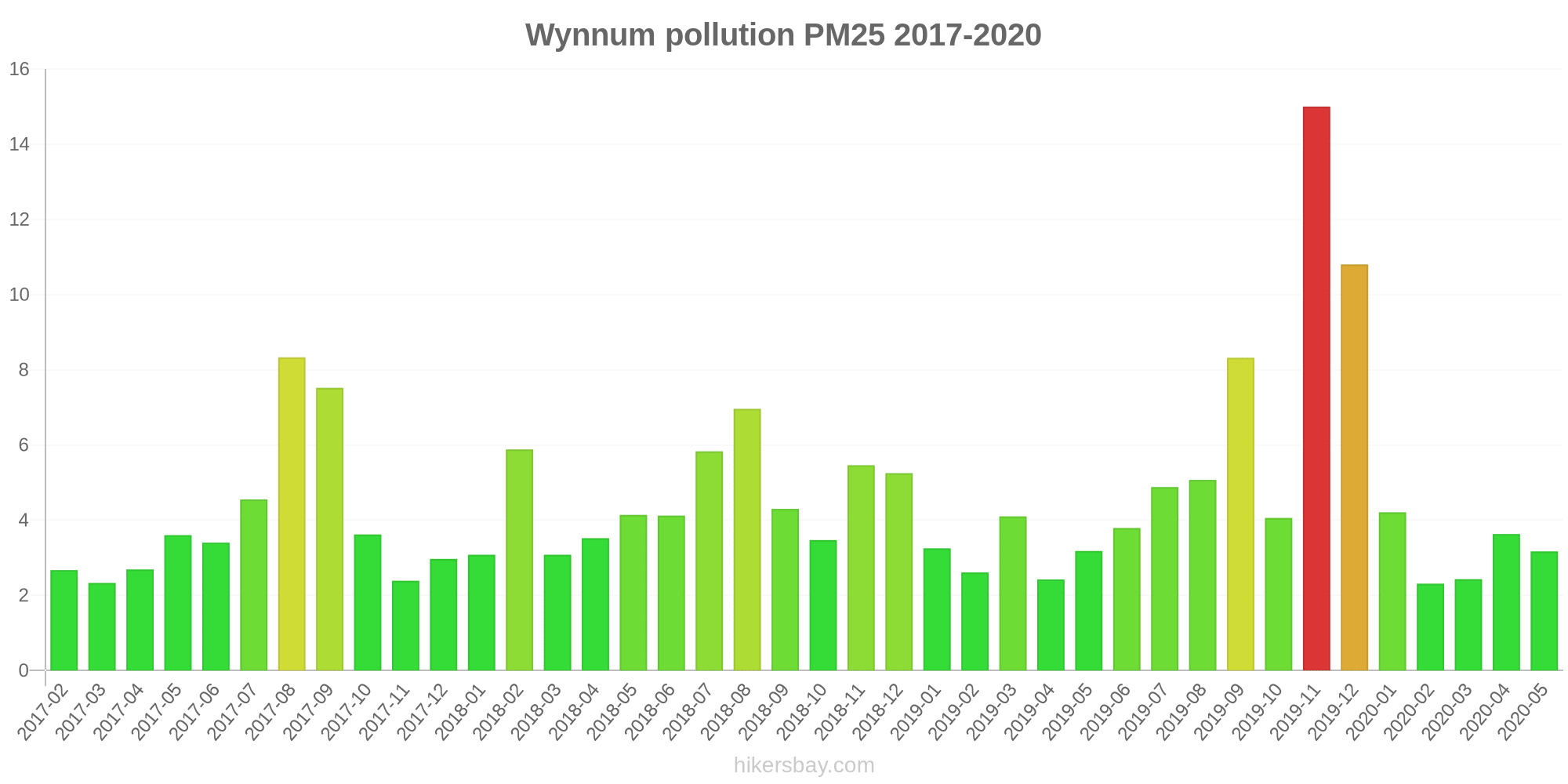
| index | 2020-05 | 2020-04 | 2020-03 | 2020-02 | 2020-01 | 2019-12 | 2019-11 | 2019-10 | 2019-09 | 2019-08 | 2019-07 | 2019-06 | 2019-05 | 2019-04 | 2019-03 | 2019-02 | 2019-01 | 2018-12 | 2018-11 | 2018-10 | 2018-09 | 2018-08 | 2018-07 | 2018-06 | 2018-05 | 2018-04 | 2018-03 | 2018-02 | 2018-01 | 2017-12 | 2017-11 | 2017-10 | 2017-09 | 2017-08 | 2017-07 | 2017-06 | 2017-05 | 2017-04 | 2017-03 | 2017-02 |
|---|---|---|---|---|---|---|---|---|---|---|---|---|---|---|---|---|---|---|---|---|---|---|---|---|---|---|---|---|---|---|---|---|---|---|---|---|---|---|---|---|
| no2:ppm | - | - | - | - | - | - | - | - | - | - | - | - | 0 | 0 | 0 | - | 0 | 0 | 0 | 0 | 0.01 | 0.01 | 0.01 | - | 0.01 | 0.01 | 0 | 0 | 0 | 0 | 0 | 0 | 0.01 | 0.01 | 0.01 | - | 0.01 | 0.01 | 0 | 0 |
| so2:ppm | - | - | - | - | - | - | - | - | - | - | - | - | 0 | 0 | 0 | - | 0 | 0 | 0 | 0 | 0 | 0.01 | 0.01 | - | 0 | 0.01 | 0 | 0.43 | 0 | 0 | 0 | 0 | 0.01 | 0.01 | 0.01 | - | 0.01 | 0.01 | 0.01 | 0.01 |
| pm25 | 3.2 | 3.6 | 2.4 | 2.3 | 4.2 | 11 | 15 | 4.1 | 8.3 | 5.1 | 4.9 | 3.8 | 3.2 | 2.4 | 4.1 | 2.6 | 3.3 | 5.3 | 5.5 | 3.5 | 4.3 | 7 | 5.8 | 4.1 | 4.1 | 3.5 | 3.1 | 5.9 | 3.1 | 3 | 2.4 | 3.6 | 7.5 | 8.3 | 4.5 | 3.4 | 3.6 | 2.7 | 2.3 | 2.7 |
| pm10 | 12 | 12 | 11 | 12 | 14 | 33 | 38 | 17 | 34 | 21 | 16 | 11 | 12 | 10 | 13 | 12 | 12 | 19 | 26 | 12 | 20 | 21 | 15 | 12 | 15 | 13 | 13 | 11 | 14 | 11 | 10 | 15 | 26 | 24 | 14 | 11 | 11 | 11 | 11 | 12 |
Hopeland

| index | 2020-05 | 2020-04 | 2020-03 | 2020-02 | 2020-01 | 2019-12 | 2019-11 | 2019-10 | 2019-09 | 2019-08 | 2019-07 | 2019-06 | 2019-05 | 2019-04 | 2019-03 | 2019-02 | 2019-01 | 2018-12 | 2018-11 | 2018-10 | 2018-09 | 2018-08 | 2018-07 | 2018-06 | 2018-05 | 2018-04 | 2018-03 | 2018-02 | 2018-01 | 2017-12 |
|---|---|---|---|---|---|---|---|---|---|---|---|---|---|---|---|---|---|---|---|---|---|---|---|---|---|---|---|---|---|---|
| pm10 | 7.5 | 10 | 7.8 | 9.4 | 24 | 35 | 41 | 24 | 39 | 16 | 9 | 5.7 | 8.5 | 8.8 | - | - | - | - | - | 6.1 | 17 | 17 | 8.3 | 9.8 | 11 | 8.8 | - | 5.4 | 10 | 6.2 |
| pm25 | 2.4 | 3.4 | 3.1 | 3.9 | 9.2 | 16 | 13 | 8 | 12 | 5 | 3.2 | 2.3 | 2.6 | 2.8 | - | - | - | - | - | 4.2 | 5.5 | 5.2 | 3.1 | 3.1 | 3.4 | 3.2 | - | 2 | 4.3 | 3.7 |
| no2:ppm | - | - | - | - | - | - | - | - | - | - | - | - | - | - | - | - | - | - | - | - | 0 | 0 | - | - | 0 | - | 0 | 0 | 0 | - |
| o3:ppm | 0.02 | 0.03 | - | - | - | - | - | - | - | - | 0.03 | 0.03 | - | - | - | - | - | - | - | - | - | - | - | 0.02 | - | - | 0.02 | 0.03 | 0.02 | - |
| co:ppm | - | - | - | - | - | - | - | - | - | - | - | - | - | 0.1 | 0.09 | 0.08 | 0.12 | 0.14 | 0.14 | 0.19 | 0.1 | 0.15 | 0.09 | 0.13 | 0.11 | - | - | - | - | - |
Miles Airport
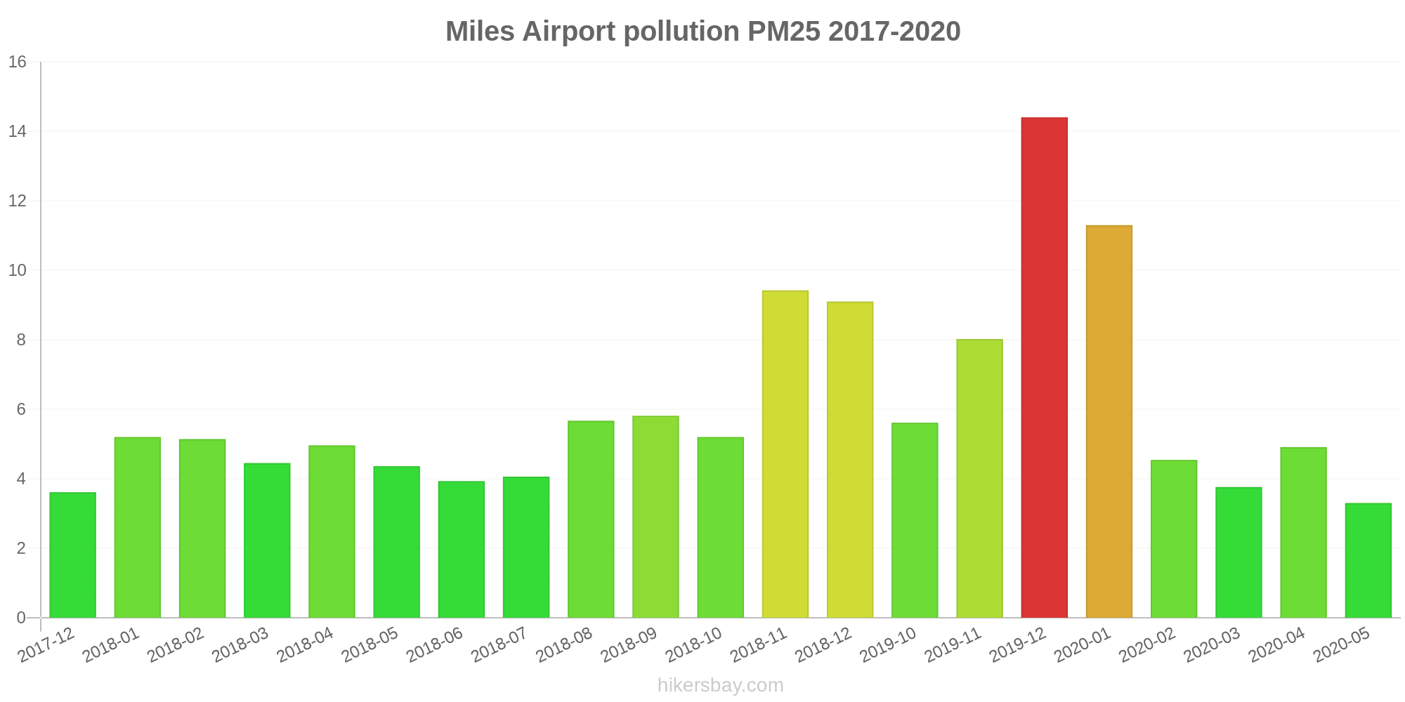
| index | 2020-05 | 2020-04 | 2020-03 | 2020-02 | 2020-01 | 2019-12 | 2019-11 | 2019-10 | 2018-12 | 2018-11 | 2018-10 | 2018-09 | 2018-08 | 2018-07 | 2018-06 | 2018-05 | 2018-04 | 2018-03 | 2018-02 | 2018-01 | 2017-12 |
|---|---|---|---|---|---|---|---|---|---|---|---|---|---|---|---|---|---|---|---|---|---|
| pm10 | 12 | 19 | 12 | 11 | 33 | 32 | 28 | 17 | 24 | 25 | 8.1 | 18 | 20 | 9.4 | 14 | 17 | 16 | 14 | 13 | 16 | 6.7 |
| pm25 | 3.3 | 4.9 | 3.8 | 4.5 | 11 | 14 | 8 | 5.6 | 9.1 | 9.4 | 5.2 | 5.8 | 5.7 | 4.1 | 3.9 | 4.4 | 5 | 4.5 | 5.1 | 5.2 | 3.6 |
| co:ppm | - | - | - | - | - | - | - | - | 0.49 | 0.21 | 0.33 | 0.11 | 0.12 | 0.12 | 0.1 | 0.23 | 0.19 | 0.19 | 0.15 | 0.12 | - |
| no2:ppm | - | - | - | - | - | - | - | - | - | - | - | 0 | 0 | - | - | 0 | - | 0 | 0 | 0 | - |
| o3:ppm | - | - | - | - | - | - | - | - | - | - | 0.03 | - | 0.02 | - | - | 0.02 | 0.02 | 0.02 | 0.03 | 0.03 | - |
Coastguard
| index | 2020-05 | 2020-04 | 2020-03 | 2020-02 | 2020-01 | 2019-12 | 2019-11 | 2019-10 | 2019-09 | 2019-08 | 2019-07 | 2019-06 | 2019-05 | 2019-04 | 2019-03 | 2019-02 | 2019-01 | 2018-12 | 2018-11 | 2018-10 | 2018-09 | 2018-08 | 2018-07 | 2018-06 | 2018-05 | 2018-04 | 2018-03 | 2018-02 | 2018-01 | 2017-12 | 2017-11 | 2017-03 | 2017-02 |
|---|---|---|---|---|---|---|---|---|---|---|---|---|---|---|---|---|---|---|---|---|---|---|---|---|---|---|---|---|---|---|---|---|---|
| pm10 | 16 | 15 | 15 | 14 | 16 | 19 | 27 | 21 | 34 | 21 | 17 | 16 | 17 | 16 | 11 | 4 | 20 | 18 | 19 | 11 | 16 | 18 | 17 | 18 | 17 | 17 | 16 | 13 | 17 | 13 | 18 | 11 | 15 |
Lennon Drive
| index | 2020-05 | 2020-04 | 2020-03 | 2020-02 | 2020-01 | 2019-12 | 2019-11 | 2019-10 | 2019-09 | 2019-08 | 2019-07 | 2019-06 | 2019-05 | 2019-04 | 2019-03 | 2019-02 | 2019-01 | 2018-12 | 2018-11 | 2018-10 | 2018-09 | 2018-08 | 2018-07 | 2018-06 |
|---|---|---|---|---|---|---|---|---|---|---|---|---|---|---|---|---|---|---|---|---|---|---|---|---|
| pm10 | 18 | 17 | 15 | 13 | 15 | 17 | 22 | 22 | 33 | 21 | 19 | 16 | 17 | 18 | 12 | 23 | 21 | 23 | 20 | 13 | 19 | 18 | 19 | 23 |
North Ward
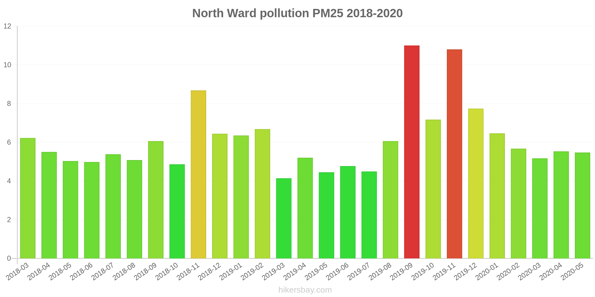
| index | 2020-05 | 2020-04 | 2020-03 | 2020-02 | 2020-01 | 2019-12 | 2019-11 | 2019-10 | 2019-09 | 2019-08 | 2019-07 | 2019-06 | 2019-05 | 2019-04 | 2019-03 | 2019-02 | 2019-01 | 2018-12 | 2018-11 | 2018-10 | 2018-09 | 2018-08 | 2018-07 | 2018-06 | 2018-05 | 2018-04 | 2018-03 |
|---|---|---|---|---|---|---|---|---|---|---|---|---|---|---|---|---|---|---|---|---|---|---|---|---|---|---|---|
| no2:ppm | - | - | - | - | - | - | - | - | - | - | - | - | - | 0 | 0 | 0 | 0 | 0 | 0 | 0 | 0 | 0 | 0 | 0 | 0 | 0 | 0 |
| so2:ppm | - | - | - | - | - | - | - | - | - | - | - | - | - | - | - | - | - | - | - | 0 | 0 | 0 | - | 0 | 0 | 0 | 0 |
| pm10 | 16 | 16 | 15 | 16 | 17 | 19 | 29 | 23 | 30 | 18 | 13 | 14 | 14 | 16 | 11 | 23 | 17 | 16 | 19 | 14 | 16 | 15 | 13 | 14 | 14 | 15 | 15 |
| pm25 | 5.5 | 5.5 | 5.2 | 5.7 | 6.5 | 7.7 | 11 | 7.2 | 11 | 6.1 | 4.5 | 4.8 | 4.5 | 5.2 | 4.1 | 6.7 | 6.3 | 6.4 | 8.7 | 4.9 | 6.1 | 5.1 | 5.4 | 5 | 5 | 5.5 | 6.2 |
Stuart
| index | 2018-11 | 2018-10 | 2018-09 | 2018-08 | 2018-07 | 2018-06 | 2018-05 | 2018-03 | 2018-02 | 2018-01 | 2017-12 | 2017-11 | 2017-10 | 2017-09 | 2017-08 | 2017-07 | 2017-06 | 2017-05 | 2017-04 | 2017-03 | 2017-02 |
|---|---|---|---|---|---|---|---|---|---|---|---|---|---|---|---|---|---|---|---|---|---|
| so2:ppm | 0 | 0 | 0 | 0 | 0 | 0 | 0 | 0 | 0 | 0 | 0 | 0 | 0 | 0 | 0 | 0 | 0 | 0 | 0 | 0 | 0 |
Menzies
| index | 2019-03 | 2019-02 | 2019-01 | 2018-12 | 2018-11 | 2018-10 | 2018-09 | 2018-08 | 2018-07 | 2018-06 | 2018-04 | 2018-03 | 2018-02 | 2018-01 | 2017-12 | 2017-11 | 2017-10 | 2017-09 | 2017-08 | 2017-07 | 2017-06 | 2017-05 | 2017-04 | 2017-03 | 2017-02 |
|---|---|---|---|---|---|---|---|---|---|---|---|---|---|---|---|---|---|---|---|---|---|---|---|---|---|
| so2:ppm | 0.01 | 0.01 | 0.01 | 0.01 | 0.01 | 0.01 | 0.01 | 0.01 | 0.01 | 0 | 0 | 0 | 0.02 | 0.01 | 0.01 | 0.02 | 0.01 | 0.02 | 0.01 | 0.02 | 0.01 | 0.01 | 0 | 0.01 | 0.01 |
The Gap
| index | 2020-05 | 2020-04 | 2020-03 | 2020-02 | 2020-01 | 2019-12 | 2019-11 | 2019-10 | 2019-09 | 2019-08 | 2019-07 | 2019-06 | 2019-05 | 2019-04 | 2019-03 | 2019-02 | 2019-01 | 2018-12 | 2018-11 | 2018-10 | 2018-09 | 2018-08 | 2018-07 | 2018-06 | 2018-05 | 2018-04 | 2018-03 | 2018-02 | 2018-01 | 2017-12 | 2017-11 | 2017-10 | 2017-09 | 2017-08 | 2017-07 | 2017-06 | 2017-05 | 2017-04 | 2017-03 | 2017-02 |
|---|---|---|---|---|---|---|---|---|---|---|---|---|---|---|---|---|---|---|---|---|---|---|---|---|---|---|---|---|---|---|---|---|---|---|---|---|---|---|---|---|
| so2:ppm | - | - | - | - | - | - | - | - | - | - | - | - | 0.01 | 0 | 0 | 0.01 | 0.01 | 0.01 | 0.02 | 0.01 | 0 | 0.01 | 0.01 | 0 | - | - | - | 0.06 | 0.02 | 0.02 | 0.01 | 0.01 | 0.01 | 0 | 0.01 | - | 0.01 | - | 0.01 | 0.01 |
| pm10 | 19 | 19 | 14 | 34 | 33 | 36 | 53 | 35 | 48 | 25 | 17 | 14 | 13 | 18 | 64 | 28 | 21 | 28 | 28 | 41 | 33 | 31 | 21 | 18 | 17 | 16 | 9.5 | 19 | 16 | 21 | 18 | 18 | 28 | 19 | 15 | 16 | 17 | 16 | 17 | 13 |